Issue Date: Thursday, May 20, 2021
Issue Time: 12:15PM MDT
Valid Dates: 5/21-6/4
It appears that Colorado (especially the eastern half of the state) is finally giving Seattle its weather back, in exchange for conditions more in line with a typical late spring here. As shown in the water vapor image, below, an amplified upper-level pattern continues across the eastern Pacific Ocean, extending into western North America. Currently, Colorado is under a transient upper-level ridge that will quickly be replaced by an incoming upper-level trough (Event #1). As was the case with the storm from last weekend, this feature will cut-off from the main flow, making it move very slowly, if at all. Some guidance has it stalling west of the Four Corners and gradually dissipating after 72-96 hours.
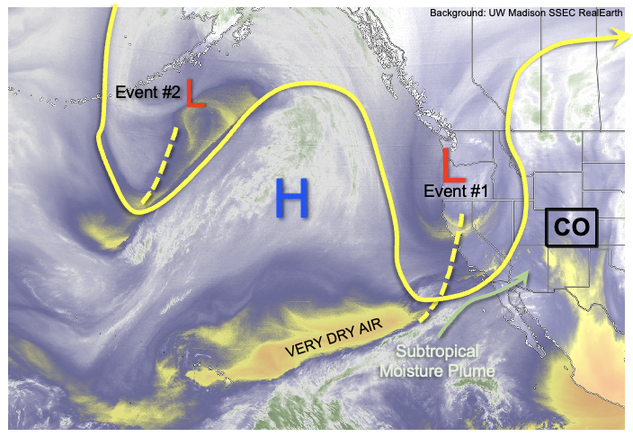
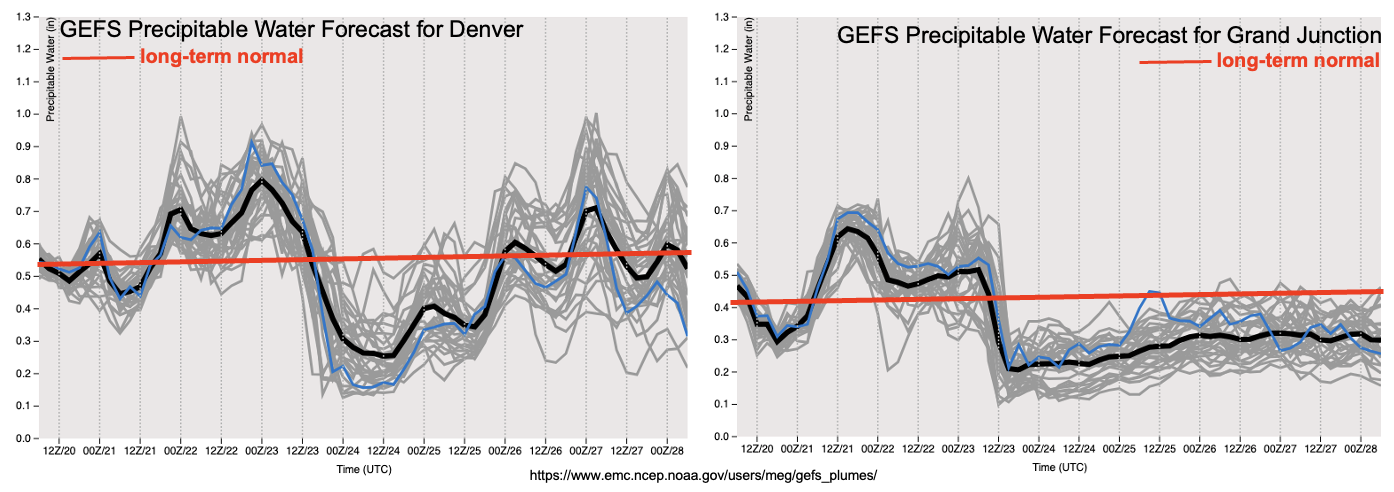
Although the GEFS PW plumes at Denver, below, show a significant increase in PW to values in the 0.8-0.9 inch range, there are several mitigating factors regarding the threat of heavy rainfall. First of all, steering winds with the system will be much stronger than the past one, which is generally a constraining factor on heavy rainfall. Second of all, because the system will slow down or even stall, only far eastern Colorado will experience meaningful upslope flow that is usually an essential ingredient for heavy rainfall east of the Continental Divide. Third of all, there will be incoming very dry air, after the initial plume of subtropical moisture on Friday, that will act to sharpen a dryline in the eastern part of the state. Anywhere west of the dryline, it is unlikely that significant rainfall will occur. The lone exception to this statement will be the San Juan Mountains that will experience a very welcomed moderate precipitation event on Friday as the atmospheric moisture plume gets perfectly directed upslope into the 14,000 foot range (as an interesting and relevant aside, note that Wolf Creek Pass is one of the wettest locations in the state with average annual precipitation likely exceeding 60 inches along its southwest face!).
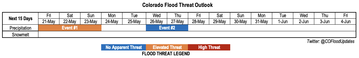
Although there are many mitigating features for heavy rainfall potential as discussed above, there is still enough moisture, instability and dynamics to warrant a low-end Elevated Flood Threat with Event #1. It is likely that the severe weather risk will steal the headlines, but storms in eastern Colorado will be capable of heavy rainfall mainly at the 1-hour duration. Furthermore, given the north-south orientation of both the dryline (an anchor of storm formation) and southerly steering winds (i.e. storms will move northward), there will be potential for training of cells that could cause flooding over the 2-hour and 3-hour durations as well.
After Event #1, dry air will overtake most of the state for several days. Afternoon thunderstorms will still be possible over the far eastern areas, but flooding appears very unlikely right now. Thereafter, some indication of a cool front passage from the north along with a resurgence in moisture from easterly return flow warrants the identification of an Event #2, currently of importance mainly for eastern Colorado.
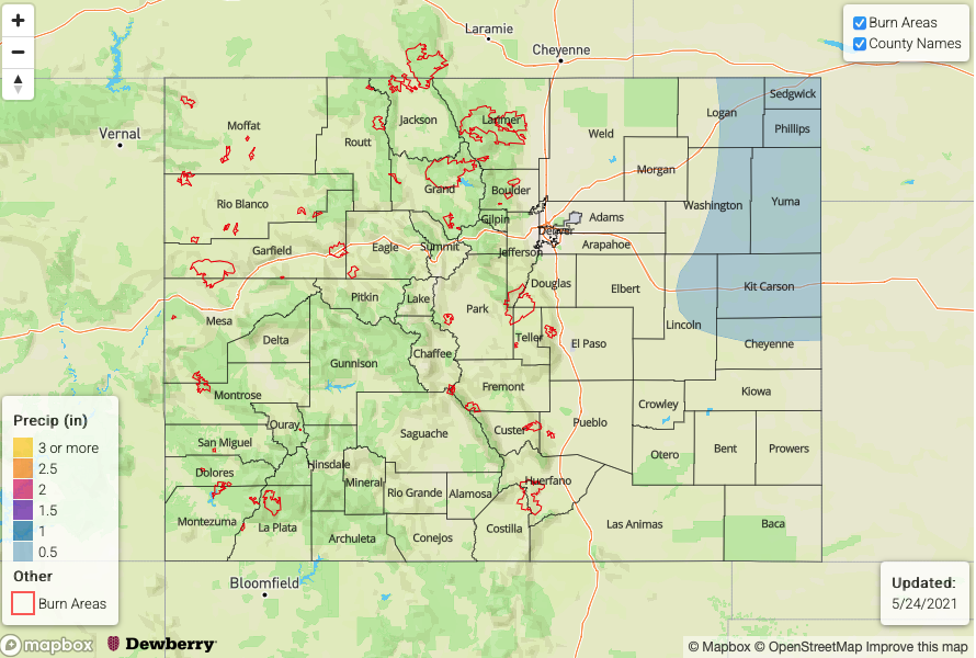
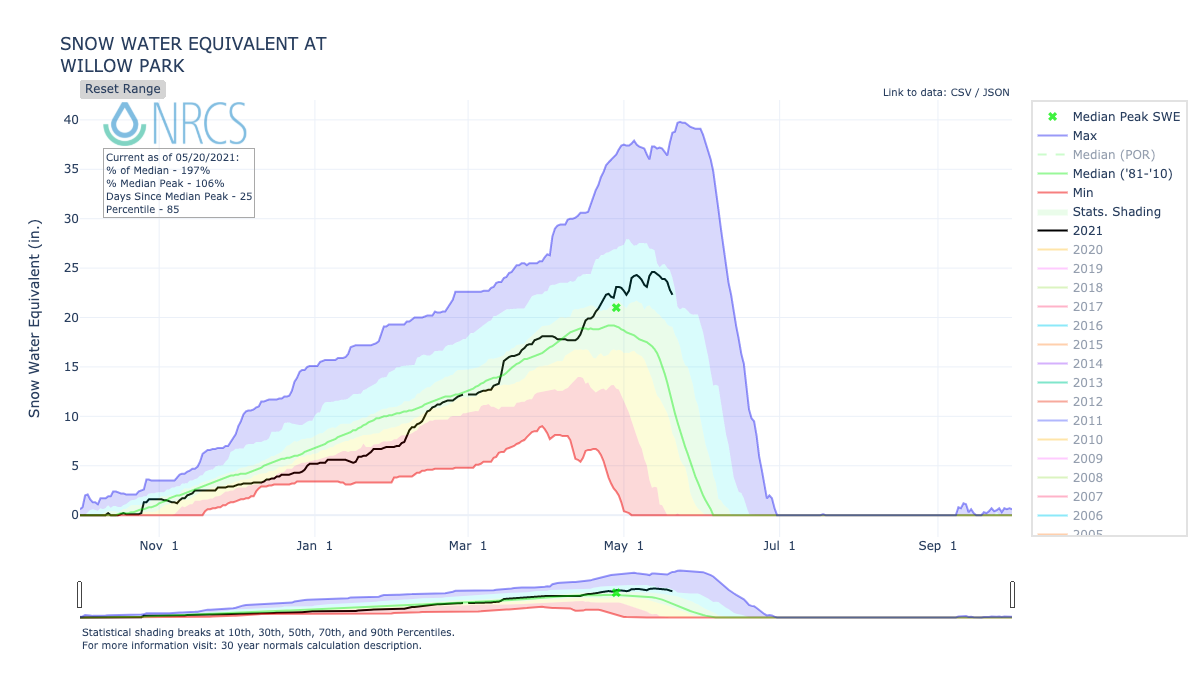
The last matter of importance is the status of the snowmelt, which typically peaks within a few weeks either side of today across the state. As we have alluded to previously, the only basin of concern is the South Platte River. Below, the Willow Creek SNOTEL site (10,700 ft) shows a SWE of 23 inches, which is almost double the normal value for this time of year. This could be a concern if very hot weather was in the forecast. However, given the presence of only slightly above normal temperatures and relatively dry conditions, it does not currently appear that snowmelt will cause any widespread flooding concerns, only minor nuisances in smaller streams.
Below, we discuss the two identified precipitation events in more detail.
Event #1: Friday-Sunday (May 21 – May 23)
A low-end Elevated Flood Threat through the period mainly for isolated short-duration flash flooding; severe weather also likely
Thunderstorm activity will begin today but rainfall (and snowfall) coverage will increase Friday-Sunday, first targeted over mainly southwest and southern Colorado where the rainfall will be most welcomed. The San Juans could see max 1-hour rainfall up to 0.6 inches, with 24-hour accumulation exceeding 1 inch over the higher terrain. Over the highest peaks, this precipitation will fall as snow. East of the Continental Divide, afternoon flare-ups of showers and thunderstorms will occur Friday-Sunday with the heaviest rainfall chances in far eastern Colorado, where PW will approach 1 inch. Along the NE, KS and OK borders, activity could persist into the evening and early overnight hours. Max 1-hour rainfall up to 1.8 inches is possible, with max 3-hour rainfall up to 3.0 inches locally. This could result in small-scale flash flooding, along with field and street ponding. In addition, severe weather will be likely with large hail and gusty winds being the primary threat.
Event #2: Wednesday-Thursday (May 26 – May 27)
No Apparent Flood Threat as storms appear to return to eastern Colorado
Although there is significant uncertainty as to the moisture return, it appears that a cool front will return enough moisture and upslope flow into the state for an increase in thunderstorm activity, mainly over the eastern Plains. Currently it appears the dryline boundary will be far enough east that only areas along the NE, KS and OK borders will stand the chance for meaningful rainfall exceeding 0.5 inches.