Issue Date: Monday, May, 24th, 2021
Issue Time: 2:40PM MDT
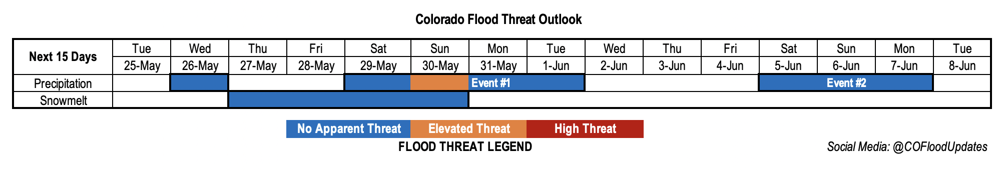
Valid Dates: 5/25 – 6/8
A chain of fairly fast-moving troughs and ridges will propagate across the state this next week. First, southwesterly and westerly flow aloft under a building ridge will help to keep the skies dry through Tuesday. On Wednesday, a weak trough breaks up this ridge and pushes some mid-level energy across the state. Without much moisture accompanying this trough, outside some isolated severe storms for the far eastern plains, it should remain dry. Then drying returns as another weak ridge builds overhead with very warm temperatures forecast. It should reach the upper 80Fs across the Southeast Plains and western valleys Friday into this weekend.
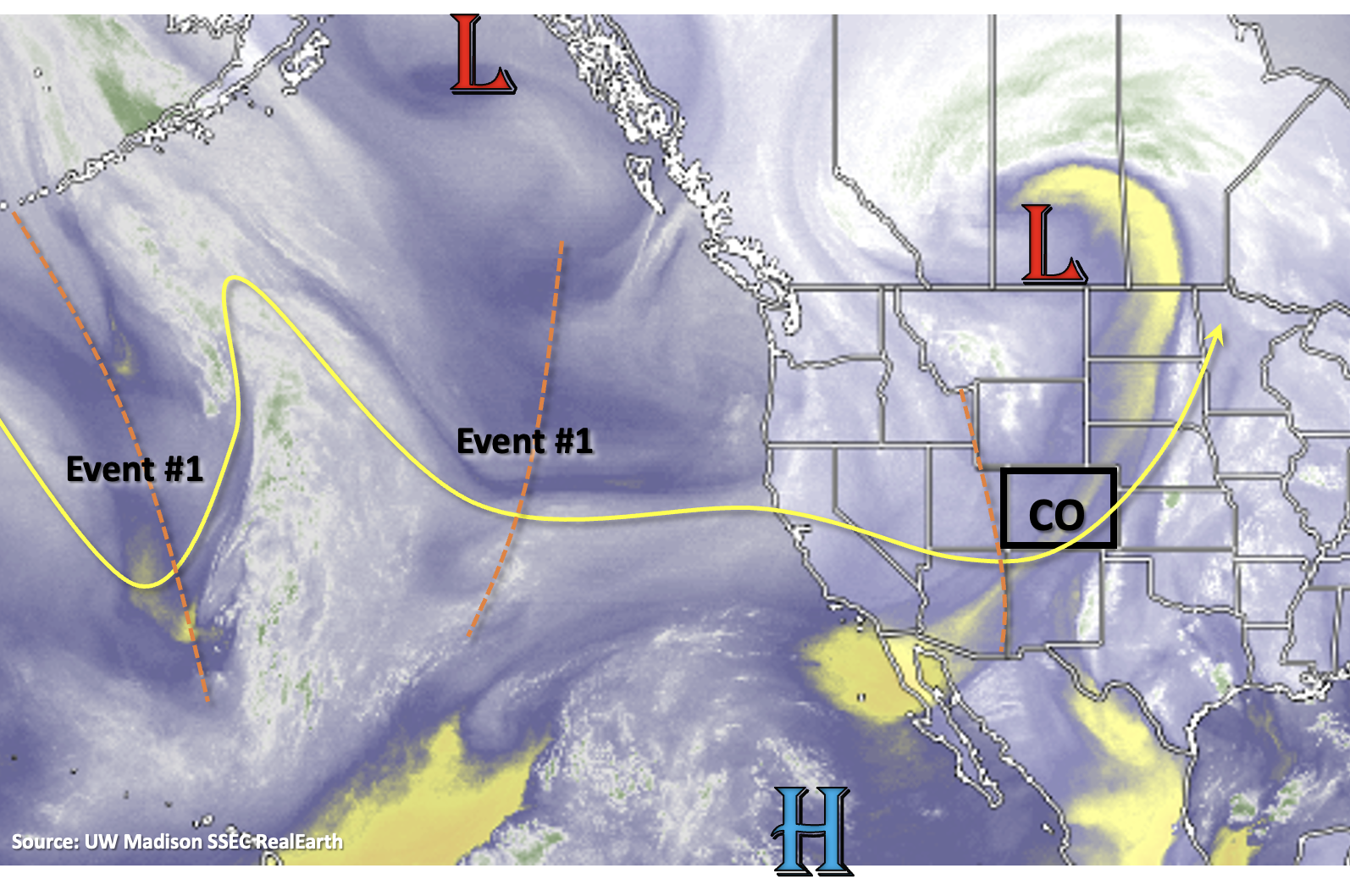
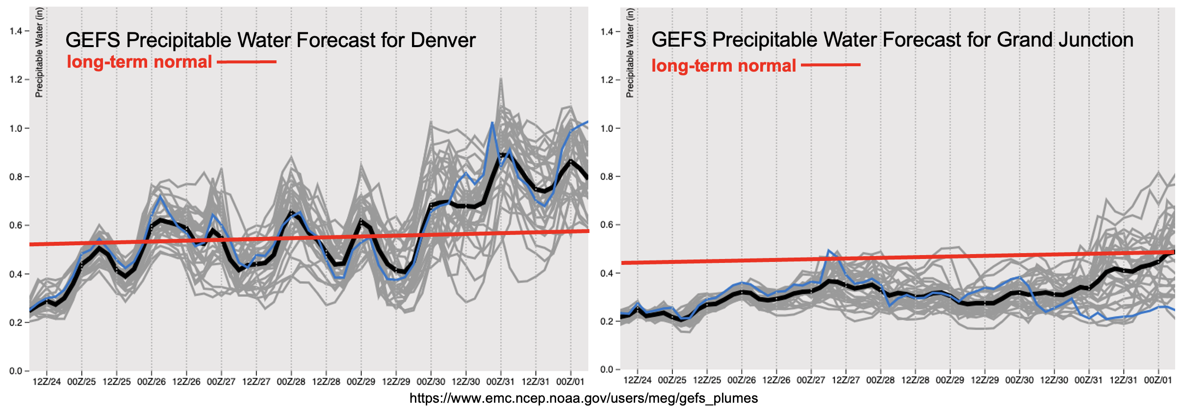
Event #1 begins Memorial Day weekend with rainfall forecast first over the plains, and then back over the mountains/adjacent plains. PW looks again to be highest over eastern Colorado, and a rapid rise in PW on Sunday will warrant an Elevated flood threat. Models hinting at cooler temperatures behind a potentially strong cold front on Monday, which if this occurs, it should help temper rainfall rates with upslope flow. However, burn areas will need to be watched closely as precipitation chances will increase over the mountains. Monday/Tuesday will be the best shot for measurable rainfall over the western mountains as winds aloft turn more southerly.
After Tuesday, northwesterly flow aloft and building ridge to our north/west will keep the state dry and help produce more seasonable temperatures. There’s still plenty of changing factors for Event #2, but a broad troughing pattern should return unsettled weather for that period and perhaps further into the work week. At this time, there is No Apparent Flood threat.
Streamflow
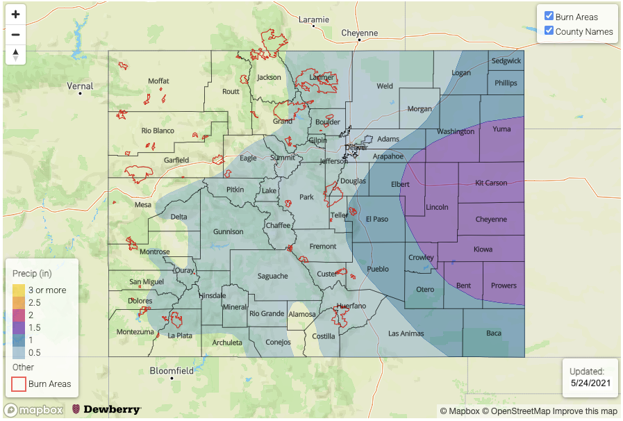
Currently, there is a Flash Flood Watch for the Purgatoire River near Las Animas where a crest up to 9 feet is forecast tonight into Tuesday midday. On Saturday, after the 3+ inches of rainfall fell over the area, the Purgatorie River at Trinidad crested at 6.63 feet. This broke the previous record of 6.2 feet, but is still well below the Action stage (10.5 feet). The Cache La Poudre River at Greeley is also at or near Action stage today, so low land nuisance flooding is likely for the next couple of days.
Warming temperatures throughout this week and into this weekend mean that runoff will likely increase. As discussed in pervious posts, this will mostly affect smaller creeks and streams over the eastern and northern mountains. You can see today’s SWE and WY precipitation totals at SNOTEL sites across your water basin here: NRCS
The cooler temperatures returning to start next week should help temper the flows and settle the snowpack at the higher elevations again. Not foreseeing any widespread, heavy rainfall this weekend over areas with potentially elevated flows right now, so there is No Apparent Threat.
Event #1: Saturday – Tuesday (5/29 – 6/1)
Elevated/No Apparent flood threat as severe storms return to the eastern plains and upslope flow returns behind a cold front.
Looks like more severe weather will be possible on both Saturday and Sunday across the eastern plains. Threats from the severe storms will include large hail, strong outflow winds, local heavy rainfall and perhaps a couple tornadoes. Steering flows look to be a little bit slower than this last weekend, so there is an Elevated flood threat for Sunday when PW should peak. The flood threat may need to be upgraded in Thursday’s FTO for Saturday. On Monday, precipitation turns more stratiform and fills in over the mountains with cooler temperatures forecast for the holiday. Burn areas will need to be watched more closely on both Monday and Tuesday for embedded convection or prolonged periods of rainfall.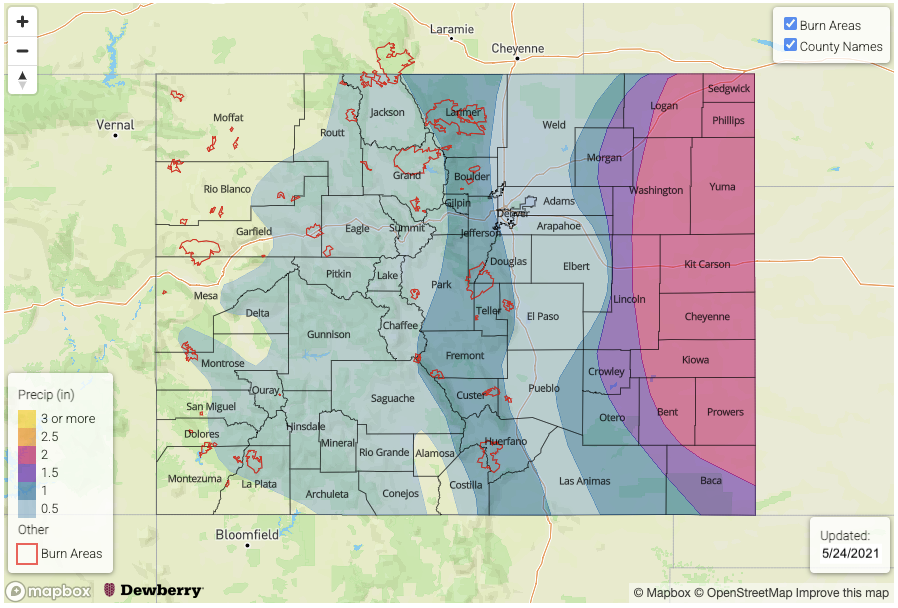
Event #2: Saturday – Monday (6/5 – 6/7)
No Apparent flood threat as a broad trough brings stormy weather back into the forecast.
Another weekend with storms is in the forecast to start the month of June. There’s still plenty of uncertainty with the forecast, but a broad trough will return rainfall chances to the state during this period. Currently this looks like an event favoring eastern Colorado again for the higher totals, but measurable precipitation over the western mountains will be likely as moisture is drawn up from the Pacific and Gulf of California. At this time there is No Apparent flood threat issued.