Issue Date: Monday, May 17, 2021
Issue Time: 1:30PM MDT
Valid Dates: 5/18-6/1
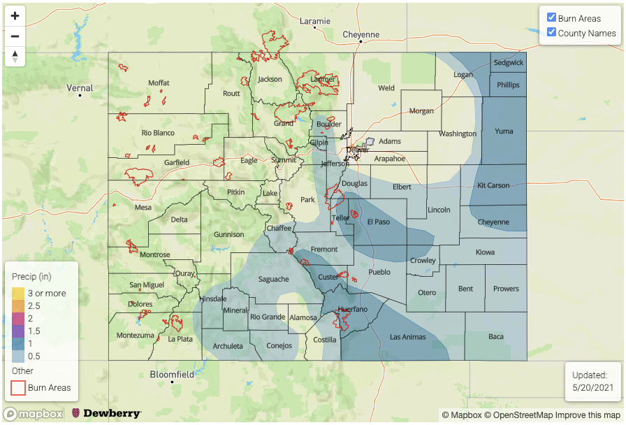
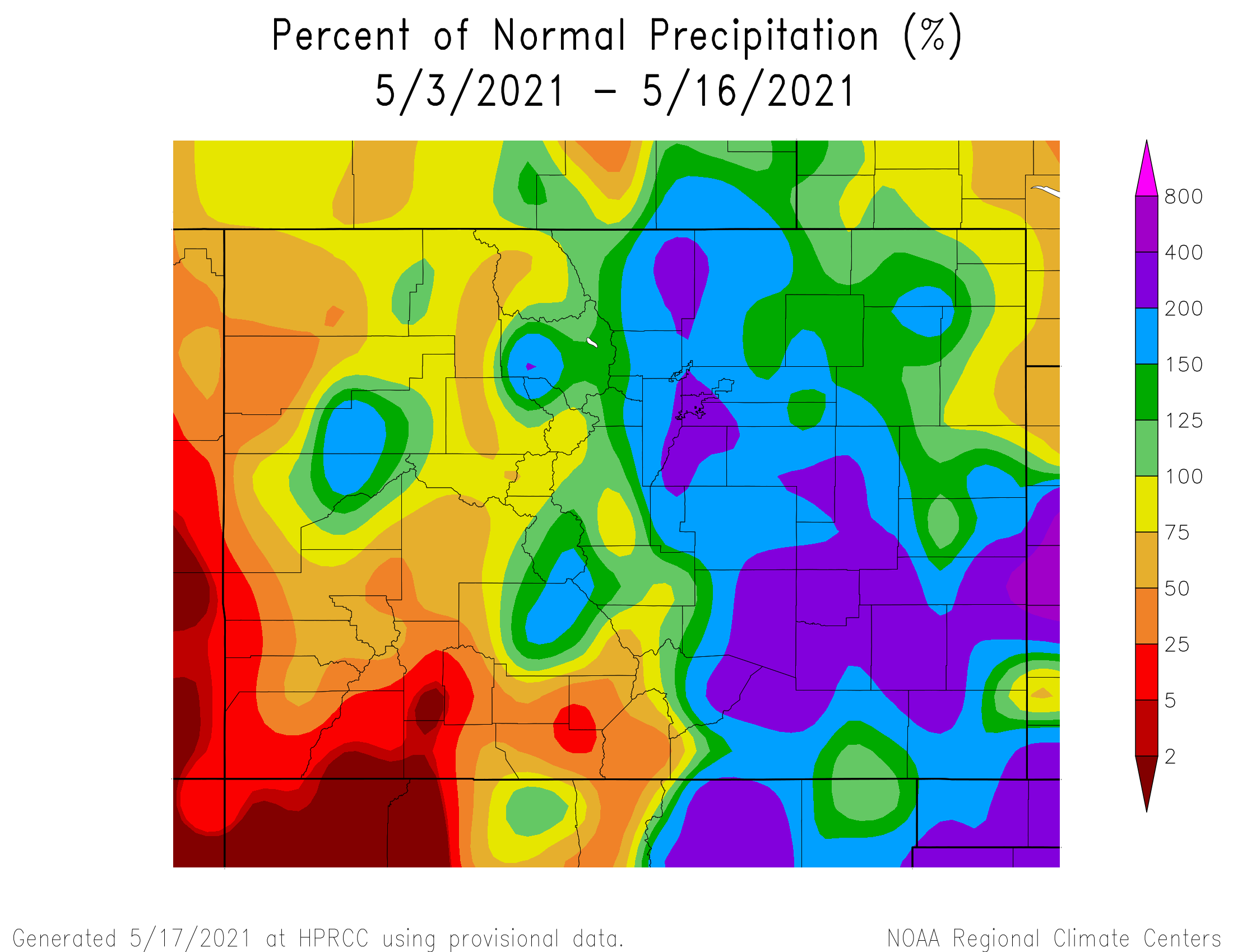
The eastern half of Colorado has experienced a prolonged very wet stretch, with plenty of severe weather and flooding reported mainly across southeast Colorado. A few counties along the Kansas border have received over 5 inches of rainfall in the past three days, which is close to half of the annual rainfall in some areas! This has certainly been welcomed from the standpoint of denting the ongoing drought, but at the expense of flash flooding. Fortunately, instances of flooding have been generally isolated and very temporary in duration thus far.
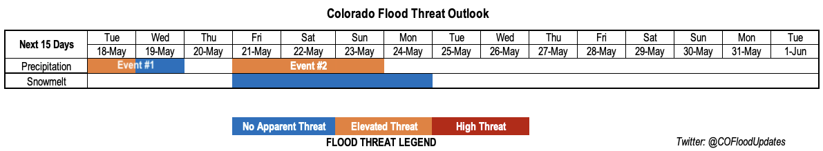
As shown in the water vapor image, below, the cut-off upper-level low pressure responsible for the recent rainfall will continue to move eastward. Tuesday will mark the last day with an Elevated Flood Threat for this event (Event #1), followed by lighter precipitation on Wednesday. However, after only a short break, with much warmer temperatures statewide on Wednesday and Thursday, another slow-moving feature (Event #2) will approach the state from the west by late Thursday. One interesting note about this feature is that it will be a combination of two disturbances, with the southern one having significant access to subtropical Pacific moisture.
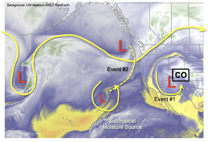
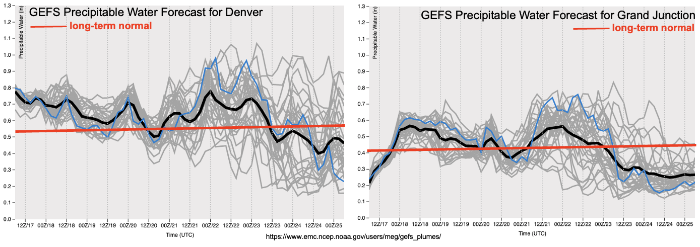
As seen in the GEFS PW plumes, below, a significant increase in moisture is expected with this event with Denver PW expected in the 0.8-0.9 inch range. As an aside, note that the existing storm only managed a PW of about 0.75 inches in Denver. Fortunately, even Grand Junction will see in an increase in moisture, although whether that translates to rainfall is less certain over northwest Colorado. One major difference between Event #2 and the ongoing event is the much stronger steering winds aloft. This will have two main implications: first, to limit rainfall rates, and second, to increase the chances of severe weather, especially east of the Continental Divide. However, despite the expected faster steering winds, strong dynamics and a large moisture plume still warrant an Elevated Flood Threat for Event #2, mainly for the isolated risk of flash flooding from short-term rainfall.
In the wake of Event #2, a significant decrease in moisture is expected, along with warmer temperatures. Thus, no additional precipitation events are currently foreseen.
Switching topics to snowpack, the only basin in Colorado that has an above-normal snowpack is the South Platte. We anticipate a strong ramp-up in snowmelt runoff by early Friday given the much warmer temperatures on Wednesday/Thursday and possible (non-snow) precipitation later. We are currently keeping an eye on the Cache La Poudre, Big Thompson and St. Vrain basins, where above normal flows are very likely. However, flows are currently expected to stay below flood stage, although smaller tributaries could certainly see some isolated areas of flooding near river banks.
Below, we describe each precipitation Event in more detail.
Event #1: Tuesday-Wednesday (May 18 – May 19)
An Elevated Flood Threat on Tuesday with risk decreasing by Wednesday
Tuesday will continue to bring the chance of heavy rainfall mainly to the Southeast Mountains, Palmer Ridge, Raton Ridge and Southeast Plains. Maximum one-hour rainfall up to 1.1 inch per hour will be possible over isolated locations, which could cause flash flooding, debris slides and mud flows. Fire burns in the Southeast Mountains (notably Decker and Spring Creek) will remain under threat for flooding. The threat of severe weather will subside by Tuesday, but large hail will still be possible in far southeast areas. Parts of the San Juans could also see some much welcomed rainfall, but it should remain below thresholds for flooding.
By Wednesday, some leftover showers and weak storms are possible, but coverage will be limited to mainly the Southeast Plains.
Event #2: Friday-Sunday (May 21 – May 23)
An Elevated Flood Threat through the period mainly for isolated short-duration flash flooding; severe weather also looking probable
Rainfall coverage will once again increase by Friday, first targeted over mainly southwest and southern Colorado where the rainfall will be most welcomed. The San Juans could see max 1-hour rainfall up to 0.6 inches, while eastward, the Southeast Mountains could see rainfall up to 1.0 inches. By Saturday and Sunday, it currently appears that coverage will move generally northeastward. We expect at least one significant round of afternoon and evening rainfall, originating off the higher terrain and moving northeast. Currently max 1-hour rainfall up to 1.7 inches appears possible, though stronger intensity could occur towards the KS/NE borders if moisture is sufficient. Organization of afternoon storms looks likely, given the strong dynamics, which could lead to threatening rainfall at the 3-hour and 6-hour durations as well. This will need to be further investigated in Thursday’s FTO. Regardless, severe weather, notably large hail (possibly very large) and strong straight-line winds appears likely for both the Southeast Plains and Northeast Plains, and possibly further west.
Rainfall chances for the Front Range, Urban Corridor and most areas west of the Continental Divide are less certain, and these areas could stay on the drier side given drier air infiltration and/or strong downsloping flow.