FTO 07-08-2021: Cooldown For Some This Weekend, Then Elevated Flood Threat As Moisture Returns

Issue Date: Thursday, July 8th, 2021
Issue Time: 1PM MDT
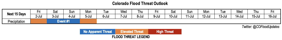
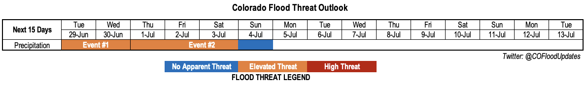
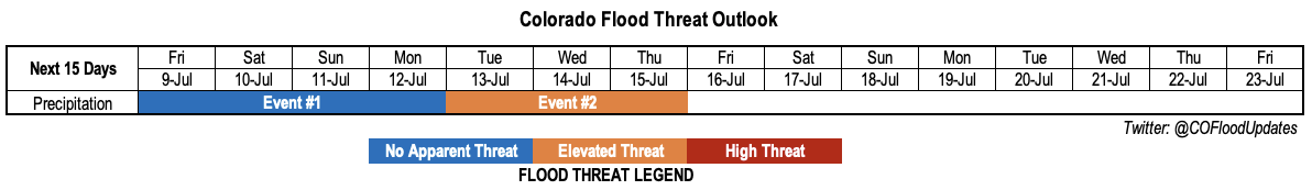
Valid Dates: 7/9-7/23

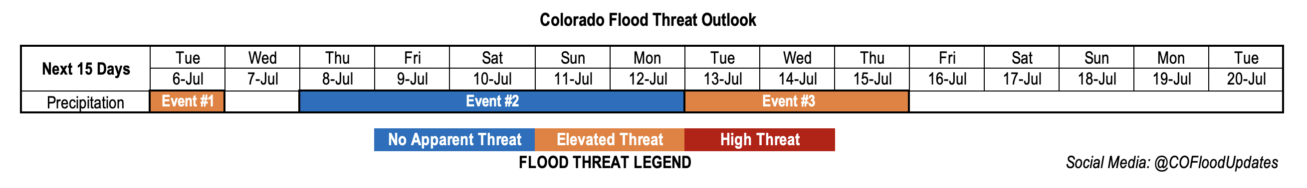
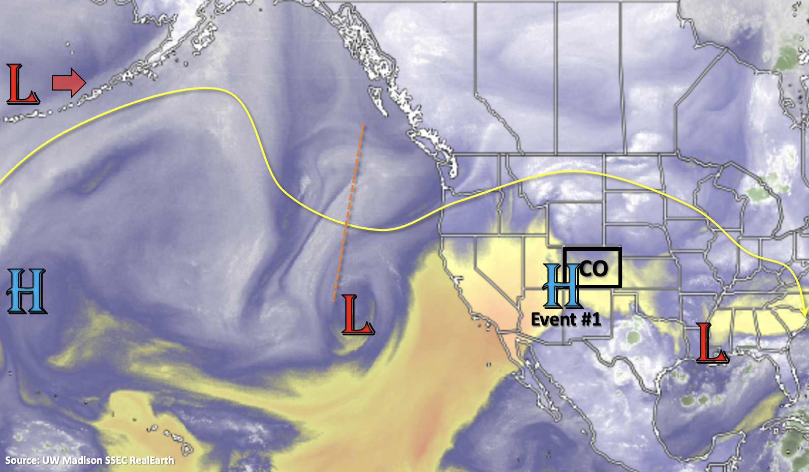
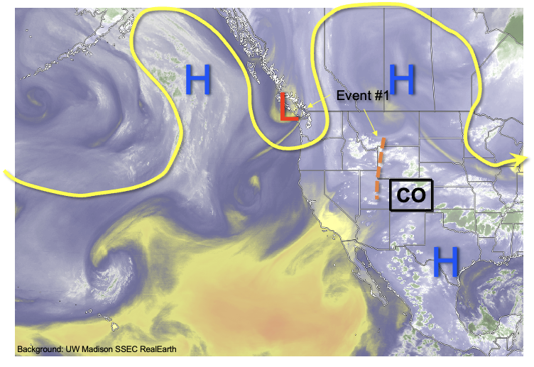
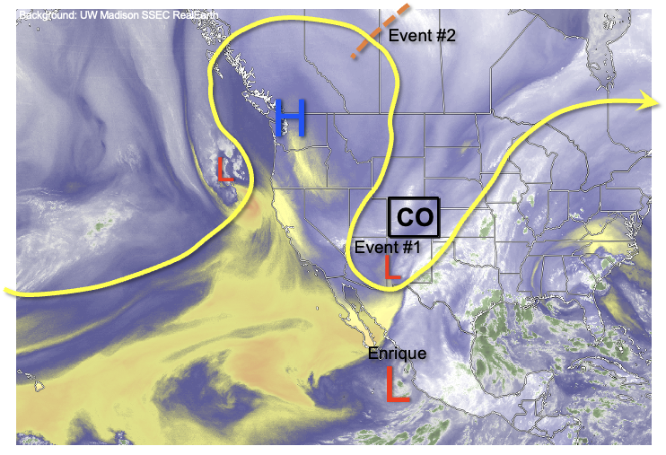
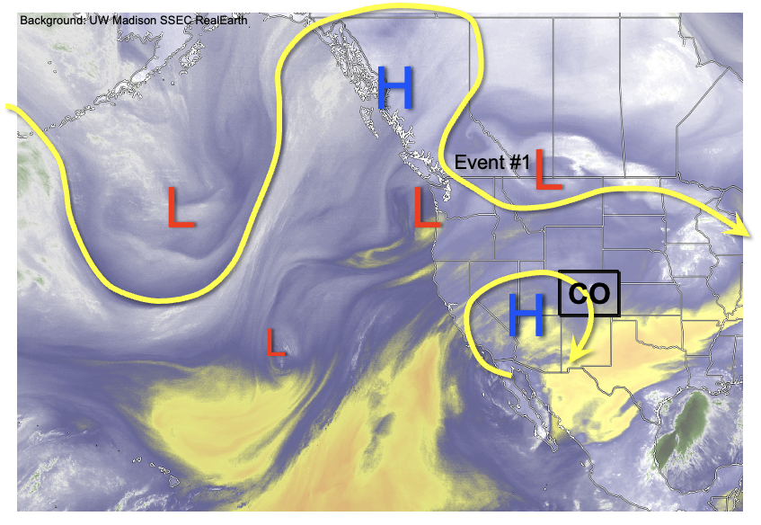
As shown in the water vapor image, below, the near record heat Colorado is experiencing today will fortunately only last another 24 hours or so as a pair of disturbances drive a strong cool front across the state on Saturday. That’s the good news. Unfortunately, only the eastern half of the state will experience much of a cooldown. West of the Continental Divide, temperatures of 10F or more above normal are expected to persist over the next 3-5 days. The culprit bringing the heat is an upper-level ridge located just west of the Four Corners this morning. This ridge will strengthen and shift west, while a trough develops over the central United States through the weekend. The cool front passage is expected to be rather uneventful as instability will be limited due to the overnight timing of the cool front. However, moisture will stay at or above normal for eastern and southern Colorado through next week, which will support at least widely scattered storms over mainly the central and southern high terrain (Event #1). Flooding is NOT expected with this event due to the limited instability.

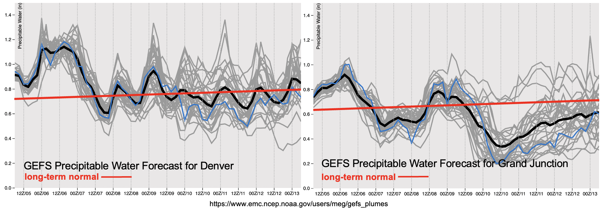
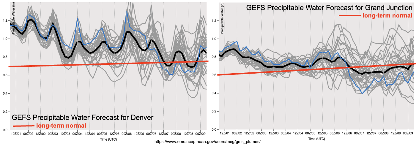
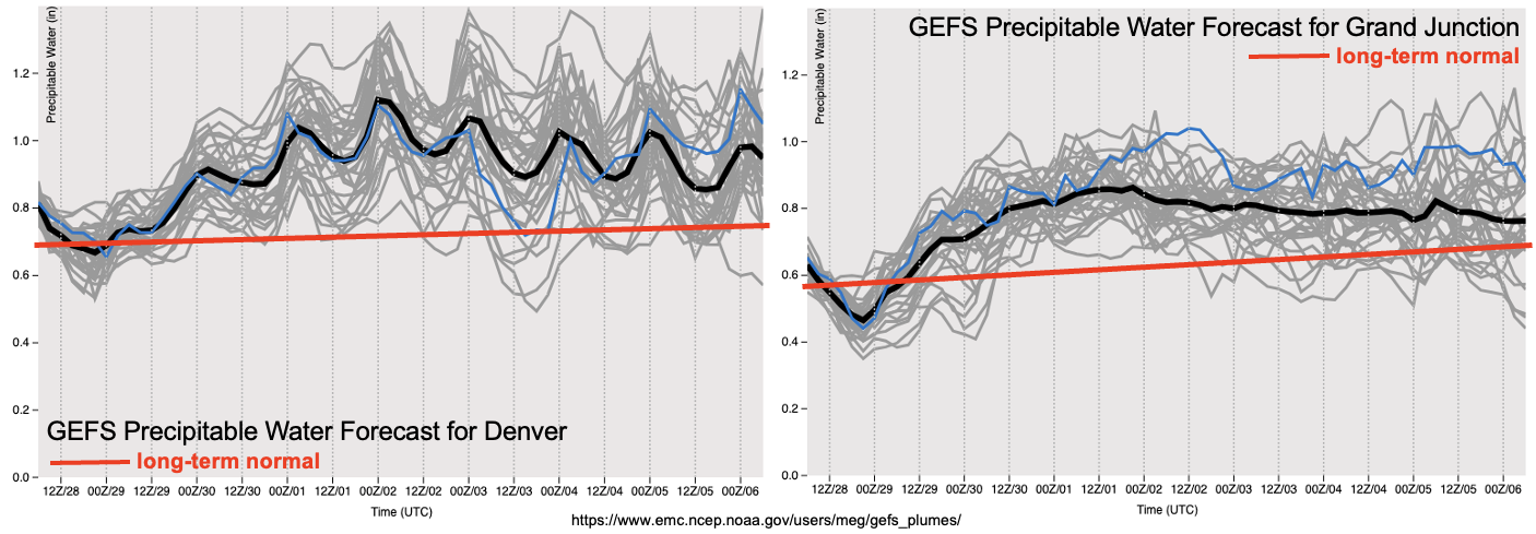
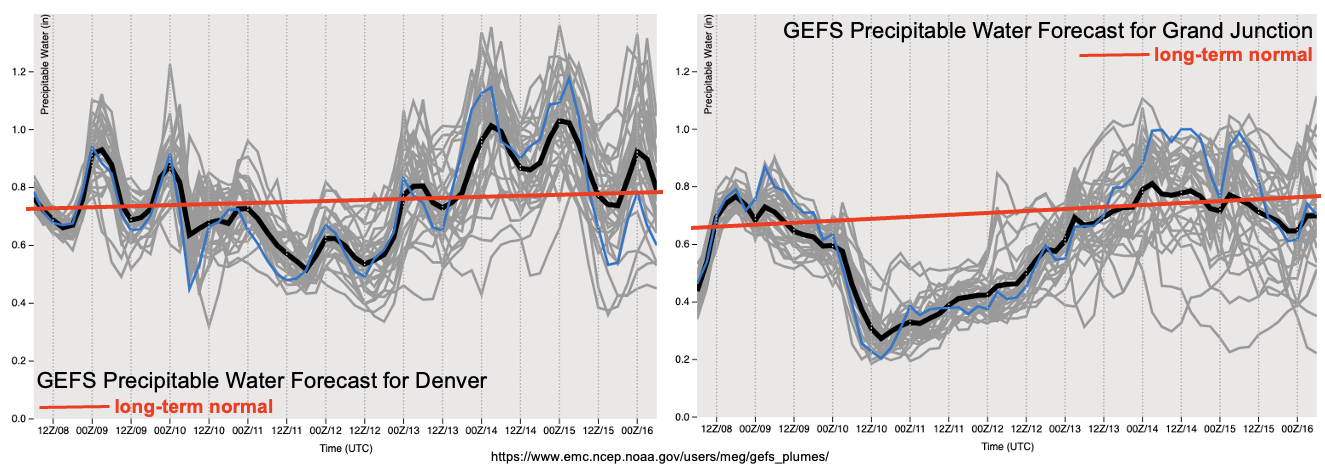
Another cool front is expected to move across Colorado early next week, this time further south. This can be seen with the notable increase in PW in both the Grand Junction and Denver forecasts, below. This, combined with some indication of weak monsoonal southerly flow over New Mexico supports a Low-end Elevated flood threat for this event (Event #2). The best precipitation chances will again be over southern and central Colorado, in consistency with climatology. Further east, the presence of strong upper-level winds suggests strong steering flow, limiting precipitation over a given point. However, with enough instability present, this could support more organized severe weather, although this looks unlikely at the moment.

After Event #2, all indications point to a return to above normal temperatures for most of the state as an upper-level ridge redevelops over the central Rocky Mountains. Thus, there is no additional precipitation events expected at this time.

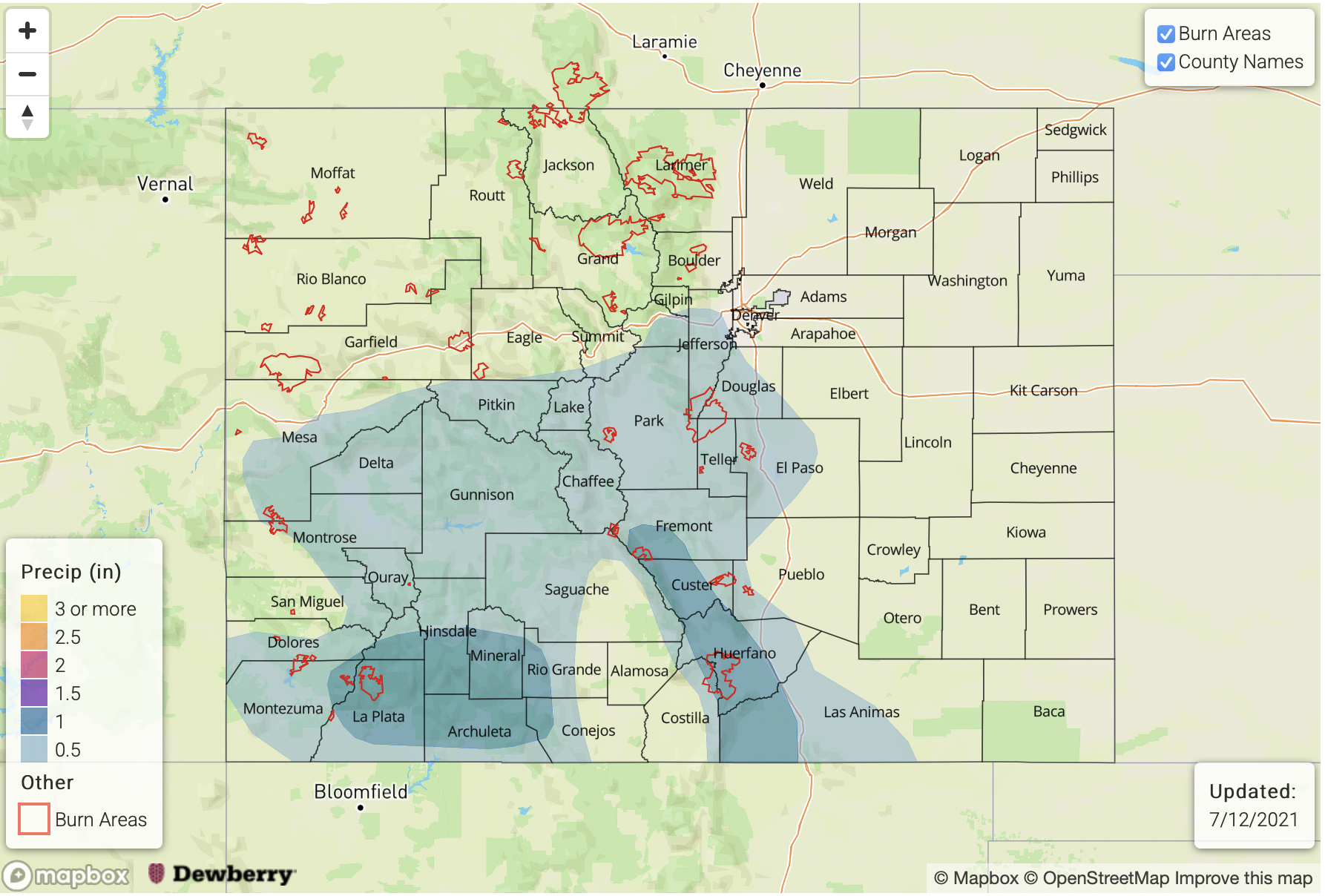
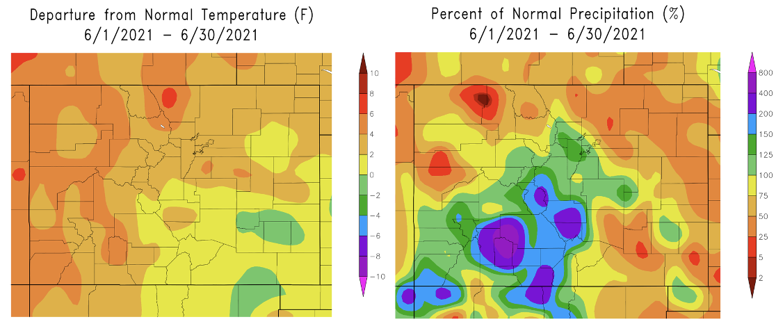
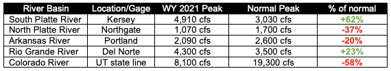
Switching topics, with it being early July, all the state’s major river basins have very likely experienced their peak flows of the 2021 Water Year. The table below summarizes the peak flow relative to the long-term average. Note that these estimates are preliminary and do not fully take into account the impact of diversions and reservoirs. Three of the five basins experienced significantly below normal flow. But, as has been widely reported on, the Colorado River saw the most drastic anomaly of almost 60% below normal. The Rio Grande flow was arguably the most unexpected as the area was in the midst of a severe drought during mid-spring that reversed quickly with a few notable precipitation events. The South Platte River also “outperformed” it’s late winter low-flow expectations given a below normal snowpack at that time. Out of all the basins, late spring and early summer precipitation is probably the most important for the South Platte River (climatologically), and this year’s accumulations were significant, ultimately yielding much above normal flow.

Below we describe the identified precipitation events in more detail.

Event #1: Friday – Monday (July 9 – July 12)

No Apparent Flood Threat as widely scattered storms expected mainly over higher terrain

Daily afternoon and evening thunderstorms are expected mainly over the Central Mountains, Southeast Mountains and San Juan Mountains. Max 1-hour precipitation up to 0.5 inches is expected, but only locally given the low storm coverage. A strong cool front could clip the northeast corner of Colorado with showers and thunderstorms late Friday and early Saturday, but with limited instability and very strong steering winds, only light to moderate precipitation is expected.

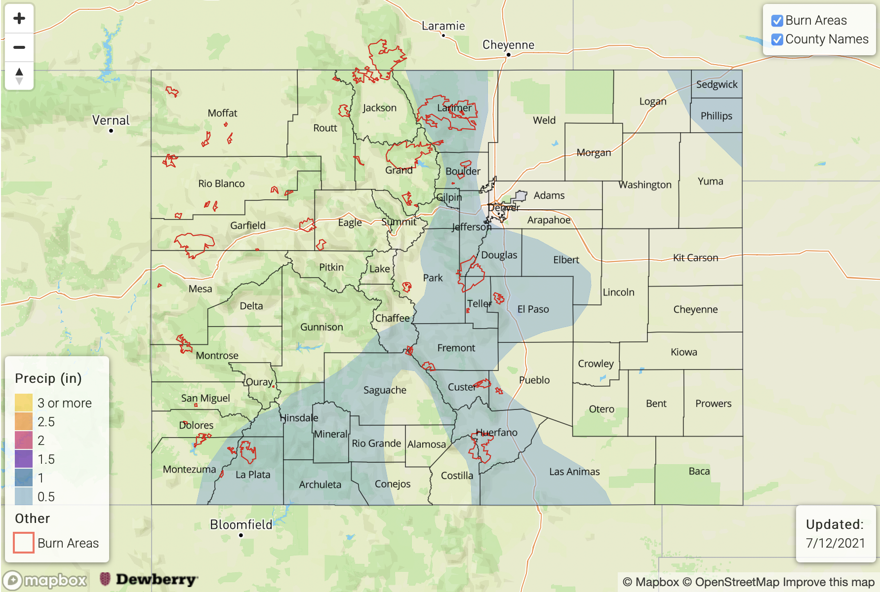
Event #2: Tuesday – Thursday (July 13 – July 15)

Elevated Flood Threat mainly for southern and central high terrain, more uncertainty over eastern Colorado

Another cool front is expected by Tuesday of next week, this time increasing moisture for most of the state. An increase in storm coverage is expected mainly for the higher elevations of the Northern Mountains, Central Mountains, San Juan Mountains and Southeast Mountains. Max 1-hour rainfall up to 0.9 inches will support isolated flash flooding, debris slides and mud flows over the higher terrain Tuesday – Thursday. East of the Continental Divide, there is significant uncertainty as the higher moisture will be offset by relatively weak instability and strong steering flow. However, given sufficient instability, strong to possibly severe thunderstorms could occur in the Front Range, Urban Corridor and Northeast Plains with an elevated flood threat. Stay tuned to the next Outlook for an update on this.

FTO 07-05-2021: One Day Elevated Flood Threat Before A Drying Trend Begins

Issue Date: Monday, July 5th, 2021
Issue Time: 2:05PM MDT
Valid Dates: 7/6 – 7/20

There will be one more day with an Elevated flood threat (Event #1) before a drying trend begins into next weekend. The High, currently located over the four-corner region, will begin to build again over Utah and Arizona after the passage of a cold front on Tuesday. While cooler temperatures are forecast behind the front on Wednesday (east), hot temperatures are expected return statewide under the building ridge by Thursday. Daily rounds of scattered storms over the mountains are expected for Event #2. The north and northwesterly flow aloft at the latter end of Event #2 may allow for a disturbance or two to move through the flow. These disturbances could slightly cool down daily high temperatures a couple degrees and create a low-end localized flood threat. So, be sure to follow the daily FTB, which will track each of these potential disturbances individually.

Generally speaking, even with the drying trend, there should still be plenty of residual moisture for scattered storms over the mountains each afternoon and evening through next weekend (Event #2). This is the time of year, climatologically, that there is the largest uptick in PW (statewide), so base moisture generally increases. Storms that develop during Event #2 are expected to favor the southern high terrains, areas along and near the Continental Divide, and eastern ridge, so expect the highest accumulations in these regions.

The PW plumes below show that moisture is forecast to drop off drastically over western Colorado by Saturday (right image). So, over the weekend, accumulating rainfall over the San Juan and Central Mountains won’t be as likely. With PW at or near normal over eastern Colorado, better coverage of storms is expected over the eastern mountains. At this time there is No Apparent flood threat issued.

Event #3 should begin sometime next week as the ridge gets squashed/flattened by a series of disturbances. The zonal flow that is expected to develop will likely move daily disturbances across the state, which will enhance lift. Moisture will likely increase as well with the High being suppressed both south and west during this period. While this event is still far out, meaning lower confidence in the forecast details, the ridge should begin to build back over the west during the tail end of Event #3. As this occurs, it will be our next shot at a monsoon moisture surge, so an Elevated flood threat has been issued. No map has been drawn below for Event #3 due to low confidence in the rainfall placement.

Keep scrolling below to read more details about each of the events.

Event #1: Tuesday (7/6)

Elevated flood threat for eastern Colorado as above average moisture and a frontal boundary combine for widespread storm coverage, including some severe storms.

Heavy rainfall over the mountains and adjacent plains from slow moving and training storms is expected for one more day on Tuesday. Moisture looks like it will start to decrease over western Colorado by this evening, so looking more to the eastern mountains for the potential flood threat tomorrow. Most likely, the heavy rainfall producing storms will be over the southern Front Range and Southeast Mountains. In additional to rainfall over the mountains, some severe storms could develop along a boundary over the Southeast Plains. Max 1-hour rain rates up to 2.25 inches (east) and 1.25 inches (west) may be possible. For the severe storms, large hail, wind and perhaps a weak tornado. Over the steeper terrains, excessive runoff will be likely again with the saturated soils, and there will likely be an increased risk for mud flows and debris slides. Field ponding, arroyo flooding and road flooding will all be possible over the plains.

Event #2: ThursdayMonday (7/87/12)

No Apparent flood threat as daily rounds of mountain precipitation develop with residual moisture under a building ridge.

Finally, a break from the well above normal moisture is on its way, which should help the eastern mountains dry out a bit. For Event #2 there is No Apparent flood threat issued as daily rounds of high-elevation precipitation will likely develop with residual moisture under the ridge through this weekend. A couple of the days could see storms develop over the eastern ridges as well. For the most part, the rainfall looks to be higher in coverage south, and accumulations should mostly along and near the Continental Divide. Should a disturbance move through eastern Colorado during the latter part of Event #2, and be timed with the peak in afternoon heating, a localized flood threat may become an issue. Be sure to follow the daily FTB, which will better track these subtle features.

FTO 07-01-2021: Moisture Persists Through Independence Day But Flood Threat Appears Limited

Issue Date: Thursday, July 1st, 2021
Issue Time: 3PM MDT
Valid Dates: 7/2-7/16

Before heading into today’s Outlook, below are June’s temperature departure from normal, and precipitation anomalies (%). A very wet and cold end to the month averaged out some of the intense early and mid-month heat, as well as brought precipitation to above normal for the southern high terrain. This was a welcome relief given that the wildfire season started with a roar during the first part of June. There are still several wildfires burning over the Western Slope, however, containment efforts have greatly improved recently with the higher humidity and widespread precipitation.

For this Independence Day weekend edition of the Outlook, we anticipate a single precipitation event (Event #1) that will last through the weekend. As shown in the water vapor image, below, Colorado remains in a typical summertime weak-flow pattern. This is courtesy of the strong ridge that has moved eastward over southern Canada, allowing disturbances to basically sit over the Rocky Mountain states without much steering flow. It is important to remember that elevated heating over our high terrain acts as a disturbance maker during most summer afternoons. This is incredibly difficult to resolve in even the highest resolution weather models.

The real forcing behind today’s High Threat precipitation event is not so much the dynamics, which, as mentioned, are rather unimpressive, but the very high moisture content. With sufficient instability and absent a mechanism to remove this moisture, we foresee daily rounds of shower and storm activity especially over the climatologically favored higher terrain. As shown below, forecasts do suggest moisture levels will come down gradually over the next 96 hours, but they will still be well above normal east of the Continental Divide. So, with some hesitation, we label Event #1 as a blend of Elevated threat and No Apparent Flood Threat. However, it is possible that the surprise will be to the upside given the elevated moisture. Please check in with daily Flood Threat Bulletins for much more refined daily forecasts. Overall though, worst-case, we expect heavy rainfall to be limited to very isolated storm cells.

Below we describe the identified precipitation events in more detail.

Event #1: Friday – Monday (July 2 – July 5)

Low-end Elevated Flood Threat Friday, followed by weaker intensity Saturday/Sunday; a cool front will bring back an Elevated threat Monday

On Friday, we expect plenty of residual moisture to fuel mainly high elevation showers and thunderstorms, although some storms may make it farther east especially over the Southeast Plains. The flood threat should stay limited to isolated higher terrain cells that could stay nearly stationary and produce over 1 inch per hour of rainfall. Lower coverage is expected on Saturday and Independence Day (Sunday), with almost all measurable rainfall likely limited to the higher terrain. By Monday, a cool front and disturbance is expected to move southward into Colorado, which will boost storm coverage over the Northeast and Southeast Plains as well as the foothills east of the Continental Divide. However, at this time, only a low-end Elevated Flood threat is expected.

FTO 06-28-2021: Low-end Elevated Flood Threat To Persist Through Early Part Of Holiday Weekend

Issue Date: Monday, June 28th, 2021
Issue Time: 2:40PM MDT
Valid Dates: 6/29-7/13

One key difference between summertime and springtime dynamics across Colorado is the former is oftentimes marked by weak steering flow. A prolonged period of weak flow is expected to develop shortly across Colorado, and with plenty of moisture around, isolated heavy rainfall will likely remain in the forecast through most of the week. Unfortunately, with weak flow situations, it is very difficult to determine which regions are most likely to be affected by the heavy rainfall.

As shown in the water vapor image, below, the remarkably strong upper-level ridge continues to be positioned over the Pacific Northwest. Although it will weaken over the next 48-hours, it will continue to maintain a position well northwest/north of Colorado. This will allow for disturbance to enter Colorado both from the south, initially, and then from the north. The first disturbance, Event #1, will be in association with a weak monsoonal pulse (for CO; it will be much more strongly felt in NM and AZ) that will affect mainly the southern high terrain. The second disturbance, Event #2, will affect both eastern and western Colorado as monsoonal moisture is also aided by multiple shortwaves expected to move in from the north.

As shown in the GEFS plumes, significantly higher than normal PW is forecasted for both Denver and Grand Junction over the next 7 days. However, with relatively weak flow and low to moderate instability, we expect on short-term heavy rainfall to be the predominant threat as organized long-duration storms will be unlikely. Nonetheless, with this much moisture available, an Elevated flood threat is warranted especially over higher terrain where it only takes about 1 inch per hour of rainfall to begin to cause runoff issues.

In addition to the long stretch of above normal moisture, we are also expecting generally below normal temperatures especially east of the Continental Divide. After Event #2, however, there are indications of a return to warmer and drier weather, so let’s welcome any rainfall we can get until then.

Below we describe the identified precipitation events in more detail.

Event #1: Tuesday-Wednesday (June 29 – June 30)

Low-end Elevated Flood Threat Friday-Sunday for mainly higher terrain

Daily rounds of scattered to numerous afternoon and evening thunderstorms are expected mainly over the higher terrain of the Southeast Mountains, San Juan Mountains, Central Mountains, Palmer Ridge, Raton Ridge and southern Front Range. Moisture will be abundant, but marginal instability and weak wind shear suggests the primary threat of 30-60 minute rainfall. Intensity up to 1.2 inches per hour will be possible, which is enough to trigger steeper terrain flash flooding, mud flows and debris slides. With enough moisture present, storms will likely make it into the lower elevations as well. Over the 48-hour period, up to 1.5 inches of rainfall will be possible over localized parts of the climatologically favored San Juan Mountains, Central Mountains, Southeast Mountains and the Pikes Peak region.

Event #2: Thursday-Sunday (July 1 – July 4)

Elevated Flood Threat to persist through Saturday

With moisture persisting, a series of disturbances are expected to enter Colorado from the north trigger more organized storms especially east of the Continental Divide. Higher terrain showers and storms will stay in the forecast, much like Event #1, but there will also be potential for activity over the Northeast and Southeast Plains. At this time, the most favored region appears to be along the NE border where max 1-hour rainfall exceeding 1.5 inches will be possible as the disturbances pass through. Over the higher terrain, max 1-hour rainfall up to 1.0 inch per hour also appear possible. Thus, overall, we expect a low-end Elevated Flood Threat to continue through at least Saturday, although stay tuned to Flood Threat Bulletins for updates on the location. By Sunday, current guidance suggests a decrease in moisture along with rising heights that should suppress rainfall coverage a bit for the 4th of July.