Issue Date: Monday, July 5th, 2021
Issue Time: 2:05PM MDT
Valid Dates: 7/6 – 7/20
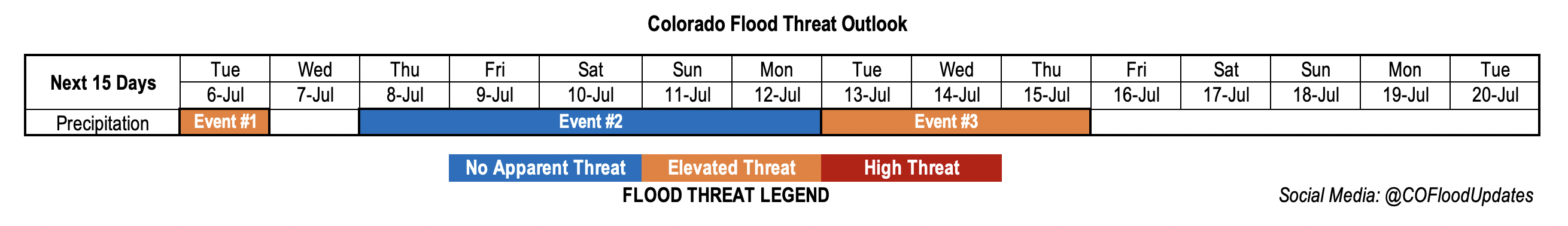
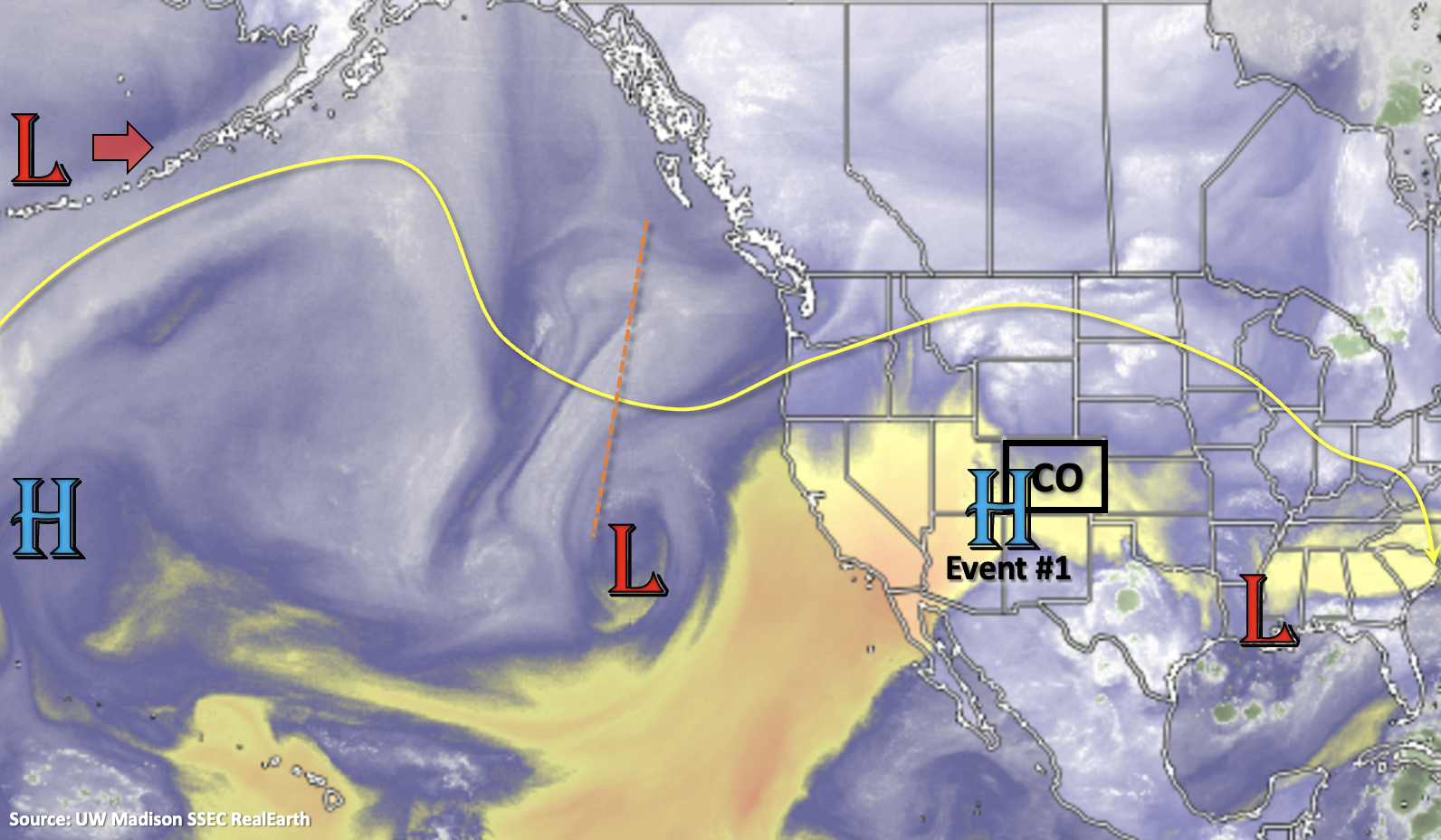
There will be one more day with an Elevated flood threat (Event #1) before a drying trend begins into next weekend. The High, currently located over the four-corner region, will begin to build again over Utah and Arizona after the passage of a cold front on Tuesday. While cooler temperatures are forecast behind the front on Wednesday (east), hot temperatures are expected return statewide under the building ridge by Thursday. Daily rounds of scattered storms over the mountains are expected for Event #2. The north and northwesterly flow aloft at the latter end of Event #2 may allow for a disturbance or two to move through the flow. These disturbances could slightly cool down daily high temperatures a couple degrees and create a low-end localized flood threat. So, be sure to follow the daily FTB, which will track each of these potential disturbances individually.
Generally speaking, even with the drying trend, there should still be plenty of residual moisture for scattered storms over the mountains each afternoon and evening through next weekend (Event #2). This is the time of year, climatologically, that there is the largest uptick in PW (statewide), so base moisture generally increases. Storms that develop during Event #2 are expected to favor the southern high terrains, areas along and near the Continental Divide, and eastern ridge, so expect the highest accumulations in these regions.
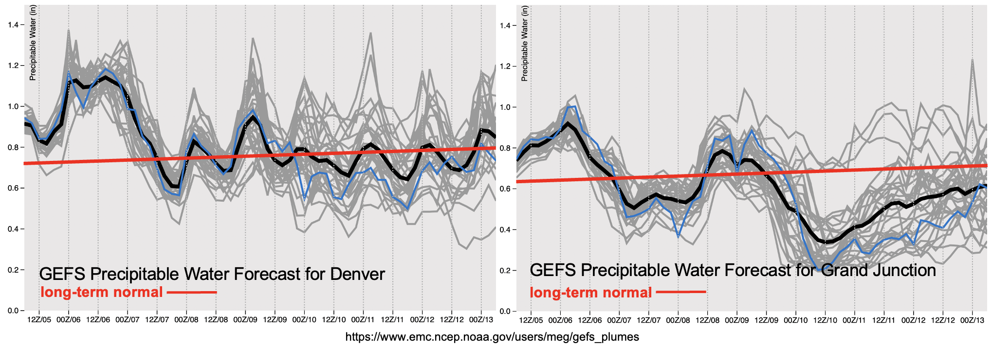
The PW plumes below show that moisture is forecast to drop off drastically over western Colorado by Saturday (right image). So, over the weekend, accumulating rainfall over the San Juan and Central Mountains won’t be as likely. With PW at or near normal over eastern Colorado, better coverage of storms is expected over the eastern mountains. At this time there is No Apparent flood threat issued.
Event #3 should begin sometime next week as the ridge gets squashed/flattened by a series of disturbances. The zonal flow that is expected to develop will likely move daily disturbances across the state, which will enhance lift. Moisture will likely increase as well with the High being suppressed both south and west during this period. While this event is still far out, meaning lower confidence in the forecast details, the ridge should begin to build back over the west during the tail end of Event #3. As this occurs, it will be our next shot at a monsoon moisture surge, so an Elevated flood threat has been issued. No map has been drawn below for Event #3 due to low confidence in the rainfall placement.
Keep scrolling below to read more details about each of the events.
Event #1: Tuesday (7/6)
Elevated flood threat for eastern Colorado as above average moisture and a frontal boundary combine for widespread storm coverage, including some severe storms.
Heavy rainfall over the mountains and adjacent plains from slow moving and training storms is expected for one more day on Tuesday. Moisture looks like it will start to decrease over western Colorado by this evening, so looking more to the eastern mountains for the potential flood threat tomorrow. Most likely, the heavy rainfall producing storms will be over the southern Front Range and Southeast Mountains. In additional to rainfall over the mountains, some severe storms could develop along a boundary over the Southeast Plains. Max 1-hour rain rates up to 2.25 inches (east) and 1.25 inches (west) may be possible. For the severe storms, large hail, wind and perhaps a weak tornado. Over the steeper terrains, excessive runoff will be likely again with the saturated soils, and there will likely be an increased risk for mud flows and debris slides. Field ponding, arroyo flooding and road flooding will all be possible over the plains.
Event #2: Thursday – Monday (7/8 – 7/12)
No Apparent flood threat as daily rounds of mountain precipitation develop with residual moisture under a building ridge.
Finally, a break from the well above normal moisture is on its way, which should help the eastern mountains dry out a bit. For Event #2 there is No Apparent flood threat issued as daily rounds of high-elevation precipitation will likely develop with residual moisture under the ridge through this weekend. A couple of the days could see storms develop over the eastern ridges as well. For the most part, the rainfall looks to be higher in coverage south, and accumulations should mostly along and near the Continental Divide. Should a disturbance move through eastern Colorado during the latter part of Event #2, and be timed with the peak in afternoon heating, a localized flood threat may become an issue. Be sure to follow the daily FTB, which will better track these subtle features.