FTO 09-16-2021: Much Welcomed Rain/Snow Event, Brief Shot Of Fall, Then Some Late Season Monsoon Uncertainty

Issue Date: Thursday, September 16th, 2021
Issue Time: 1PM MDT
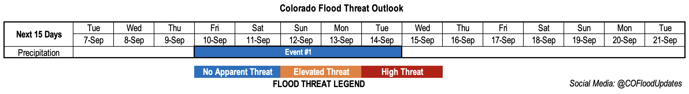
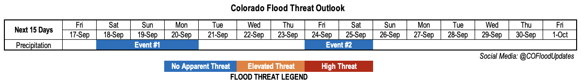
Valid Dates: 9/17-10/1

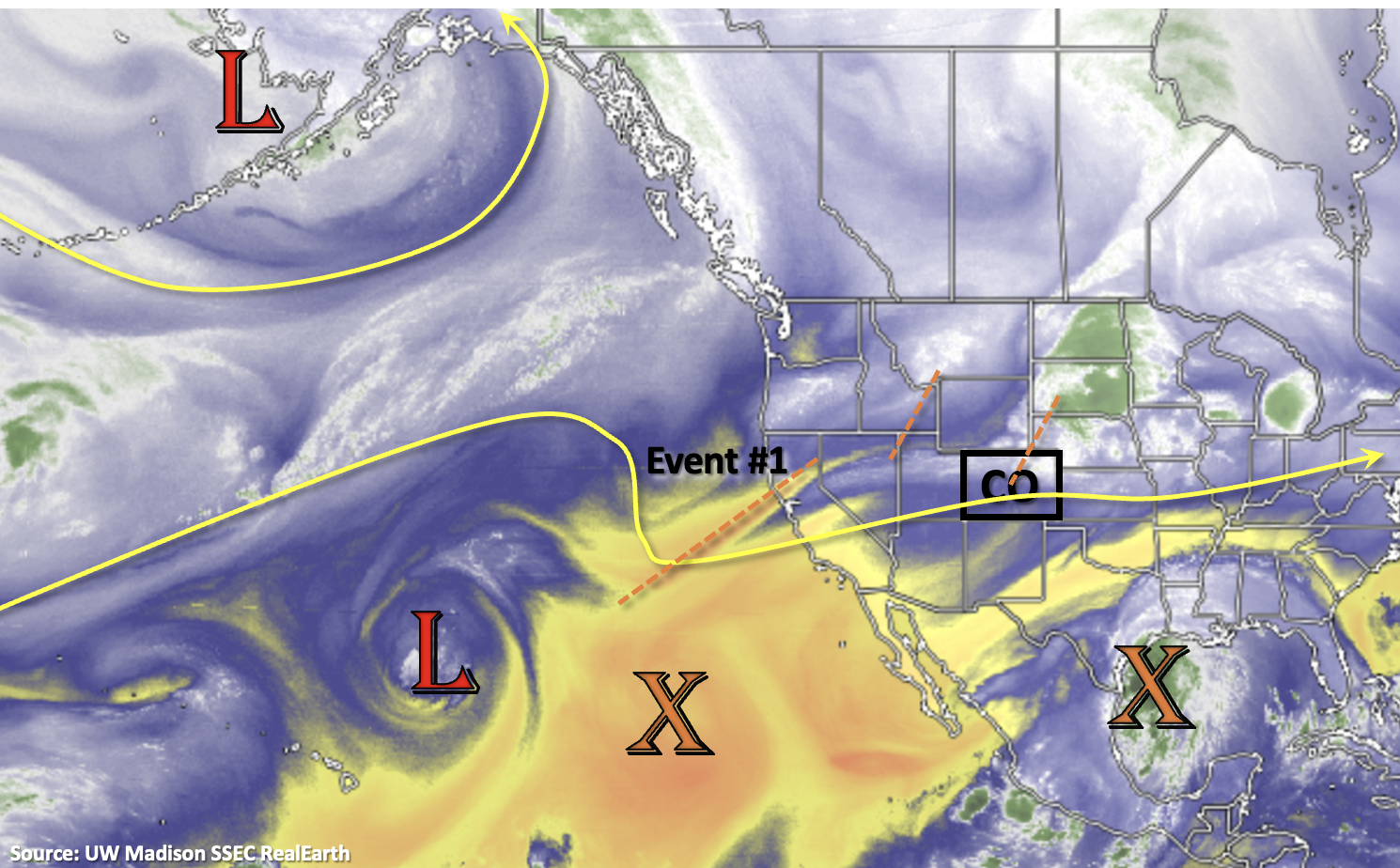
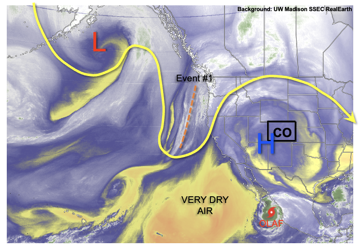
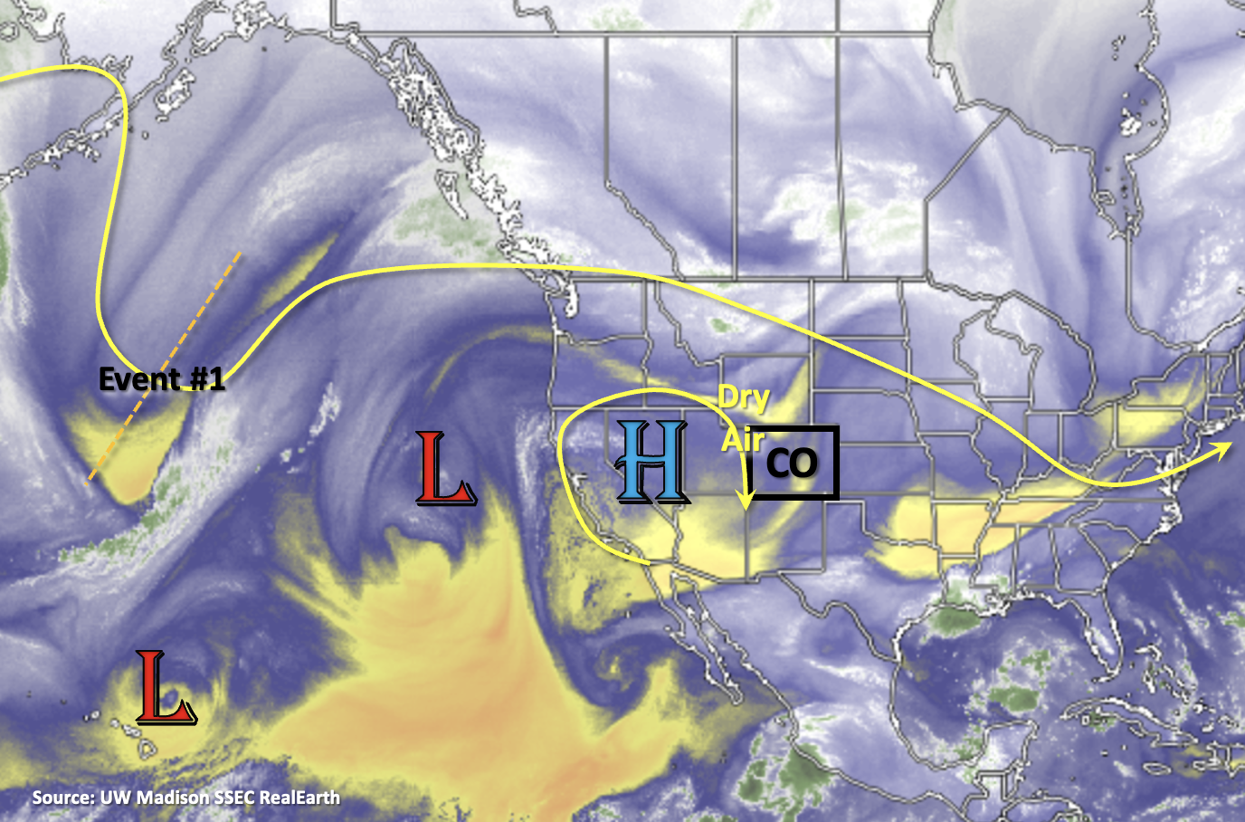
A hot start to September has left the whole state with temperatures as much as 8F above normal through the first half of the month, leaving many yearning for some fall weather. Fortunately, Mother Nature will answer the call, at least briefly. As shown in the water vapor image, below, a series of strong troughs will persist over the northwest quadrant of the US for the next 3-5 days ushering in cooler weather. Additionally, at least some moisture advection will support a few days of scattered to locally numerous rain (and yes, snow) showers mainly over the drought besieged Western Slope (Event #1).

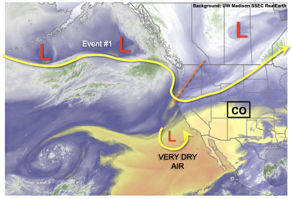
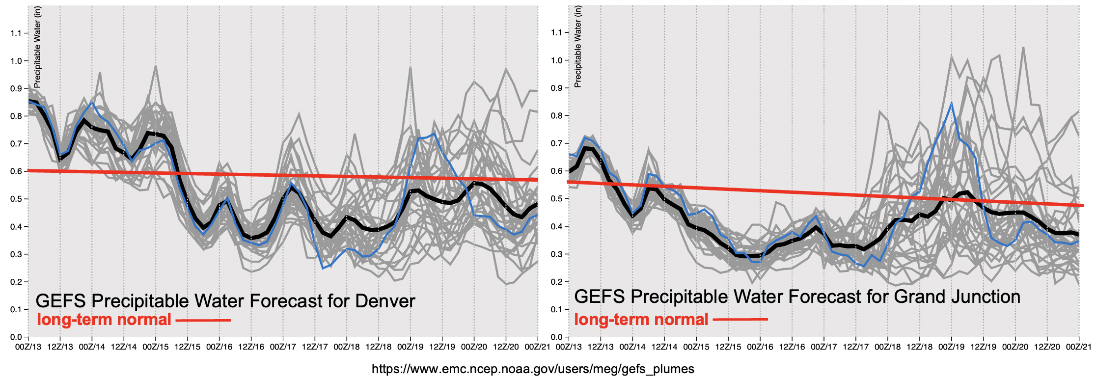
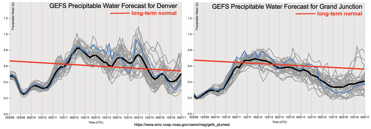
As shown in the forecast Precipitable Water (PW) plumes, below, it will not be easy to get moisture into the state, given the very large pool of extremely dry air over the eastern Pacific (see water vapor image). But nonetheless, moisture will arrive instead from the northwest and provide a 48-hour window of rain showers, snow showers and a few thunderstorms (mainly on Sunday). Coverage will be highest over the central and western parts of the state through Sunday, and then shift eastward on Monday. Unfortunately, the southeast quadrant of the state appears to be left out as dynamics will stay largely to the north.

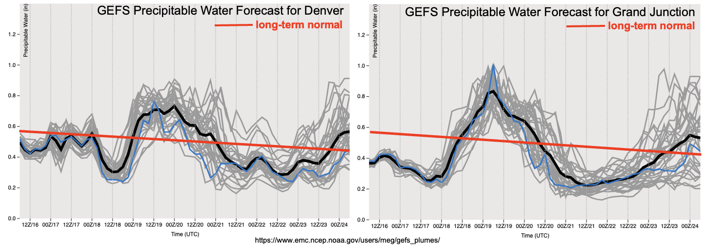
After the major cooldown associated with Event #1, warming and significant drying is expected statewide with temperatures reverting right back to above seasonal normal. Thereafter, an unusually high amount of disagreement appears in guidance, which can actually be seen in the Grand Junction PW plumes ranging from 0.2 to 0.9 inches by late next week. One set of guidance suggests a strong cut-off low over California will be able to draw much above-normal monsoonal moisture into western Colorado for at least some scattered showers and storms. However, this is completely absent in other guidance with generally dry, warm northwesterly flow prevailing. Given the monsoon season is not quite over, we will at least identify the possibility of this occurring, Event #2. Although, even if the wetter solution occurs, it is unlikely that there will be a flood threat due to fast steering flow and only marginal moisture.

The identified precipitation events are described in more detail below.

Event #1: Saturday – Monday (September 18 – September 20)

No Apparent Flood Threat As Multiple Cool/Cold Fronts Bring Showers And Weaker Storms

There will be a slight chance of showers and weaker storms on Saturday over the Western Slope but only very light precipitation is expected. An increase in precipitation coverage is expected by early Sunday as an initial, weak cool front approaches the state. Moderate intensity rainfall will be possible over central and northern Colorado with max 1-hour values up to 0.5 inches locally. Given sufficient instability, a few storm cells could become severe with damaging wind gusts as they race across the landscape at 30+ mph. Cooler temperatures will begin to overtake the state later Sunday and rain showers will switch to snow showers over the higher terrain of the entire state. By Monday, a more significant cold front will move through the state, which will support additional scattered rainfall and higher elevation snowfall. Isolated to scattered precipitation could also arise over the eastern Plains. However, instability looks almost non-existent by Monday and any thunderstorms that do manage to form will be of the dynamically-driven “low-top” variety and not capable of producing sustained heavy rainfall as they race eastward. Overall though, a widespread light to moderate precipitation event is expected especially for the Western Slope.

Event #2: Friday – Saturday (September 24 – September 25)

Significant Uncertainty But Some Monsoonal Moisture Could Support Western Slope Precipitation; No Anticipated Flood Threat

A return of monsoonal moisture is possible, which would lead to scattered showers and weaker storms mainly over the Western Slope. At this time, even the wetter scenarios would not produce much above 0.5 inches of total precipitation. Thus, a precipitation map is not needed.

FTO 09-13-2021: Quick Cool Down Before Hot & Dry Weather Return Through This Weekend

Issue Date: Monday, September 13th, 2021
Issue Time: 3PM MDT
Valid Dates: 9/14 – 9/28

We’ve got a quick one-day event tomorrow that rounds out Event #1 from last Thursday’s FTO. Zonal flow should push another shortwave across the state, which will help spark some post-frontal upslope flow storms. This event is expected to only affect eastern Colorado (central and south) where there will be more instability and plenty of remaining moisture for storm development. It will likely be too stable for any rainfall north of the cold front that passes through this evening; however, the passage of the cold front means a return to cooler temperatures over the northern tier of Colorado. So, enjoy it because high temperatures quickly rebound by Wednesday, as north and northwesterly flow pull a very dry air mass overhead. Expect the above average temperatures to last through the weekend.

By tomorrow morning, PW over Grand Junction (right image, below) drops off well below the seasonal average. With the dry air overhead, and another round of above average temperatures through the end of the week, it’s likely that already dry fuels will continue to worsen. This could help cause an increase in fire danger over the northwest corner of the state towards the end of the week when surface winds look to increase between 15 and 20 knots (not shown). There’s a bit of uncertainty about some subtropical moisture making its way northward this weekend for rainfall over western Colorado. If there is moisture return, it will likely be elevated moisture, which could spark some high-based thunderstorms. These (possible) dry thunderstorms also have the potential to increase fire danger over the area on Saturday and Sunday. Over eastern Colorado, it’s likely that PW will stay below average after tomorrow. Precipitation chances should drop off with the drier air overhead, although a couple high-based storms over the mountains may be possible closer to the end of the week and into this weekend.

After another week of warm weather, it is looking likely that early next week we will see our first push of colder air from the north. It could get quite chilly Monday and/or Tuesday with snow possible at the highest elevations. With the passage of the cold front, it’s also likely that precipitation will return to the forecast. Right now, it’s looking more like a snow/stratiform rainfall event, so there is No Apparent flood threat for Event #2. The timing of the cold front’s passage is about right, because we are nearing the time for our first frost and freeze of fall. Below are a handful of locations across the state with freeze/frost dates. In the last column are the 10th, 50th and 90th percentile dates for each location and respective threshold. If you cannot find a location that’s near you, head on over to the NCEI site HERE.

Event #1: Tuesday (9/14)

NO APPARENT flood threat is issued for scattered post-frontal storms over eastern Colorado.

Post-frontal upslope storms are likely to fire tomorrow afternoon. This event will most likely affect eastern Colorado, both central and south. There’s a good chance that it will be too stable north of the front for any rainfall as well as over the far Southeast Plains. Some higher totals may be possible if better surface moisture can hang on and not be mixed out by the incoming, dry northwesterly flow. Max 1-hour rain rates up to 1 inch may be possible, but there is NO Apparent threat at this time as storms should be moving rather quickly. Faster storm motion to the southeast should limit the flood threat from any individual storm. In addition to rainfall, a couple severe storms are possible with large hail and damaging outflow winds being the main threats. These severe storms would most likely form east of I-25. More accurate details will be available tomorrow morning, so be sure to tune back into the FTB for the latest.

Event #2: MondayTuesday (9/20 – 9/21)

Our first real taste of fall will likely arrive next week, and with it, stratiform rainfall and snow (high elevations) should return to the forecast. NO APPARENT flood threat is issued.

Still a bit of time for this to play out, but it looks like our first real cold front of the season will arrive sometime early next week. Models are in fairly good agreement about the strength of this system, so we should see a major cool down with snow possible over the mountains. Not a lot of rainfall is anticipated with this event, and it’s likely most of the rain will be more stratiform in nature than convective. Be sure to tune into the next FTO (Thursday) as details will likely change and evolve over the next several days. No map has been drawn due to the precipitation amounts anticipated being under 0.50 inches.

FTO 09-09-2021: Limited Rainfall To Return, But Main Story Continues To Be September Heat

Issue Date: Thursday, September 9th, 2021
Issue Time: 12:45PM MDT
Valid Dates: 9/10-9/24

On the morning of September 9th, exactly one year ago, most of Colorado awoke to find rare but significant early-season snowfall accumulation even for lower elevation locations (see CoCoRaHS map below). However, in the prelude to this event, the state experienced a 72-hour period of scorching weather with an all-time high September record of 101F set in Denver on September 5th.

Fast forward to now, and we see at least one similarity to 2020: the notable September heat (and just to be clear: no snow is coming!). As shown below, central and eastern Colorado have started the first week of September 2021 up to 5F above normal. This metric will rise sharply in the next few days as more near-record or even record heat is expected, amidst the background of declining seasonal normal temperatures.

As shown in the water vapor image, below, the culprit behind the current heat is the combination of very dry air (i.e. limited cloud cover) over the southwest US (and in fact extending all the way into the eastern Pacific Ocean), as well as strong ridging aloft. This ridge will hold its ground for roughly the next 48-72 hours, before somewhat succumbing to an incoming trough currently entering the US West Coast. However, the trough’s dynamics will weaken considerably as it moves closer to Colorado, so only isolated to scattered showers and thunderstorms are currently expected with this Outlook’s only precipitation event, Event #1.

As shown in the forecasted Precipitable Water (PW) plumes, a significant increase in moisture is expected statewide, to values more in line with their mid-September average. Furthermore, there will be at least marginal instability beginning Saturday to support isolated thunderstorms. However, the main limitation to rainfall will be strong steering flow, which will make it difficult to accumulate more than 0.5 inches of rainfall in any given location.

By the early and middle portion of next week, a larger trough will setup over the Pacific northwest. For Colorado, this implies generally southwest steering flow and the continued import of dry Pacific air (also seen well in the PW forecasts above). Temperatures will cool off a bit by Monday, but are likely to hover at least slightly above seasonal normal for most of next week. One interesting caveat to this forecast is the eventual fate of Hurricane Olaf. This storm will soon enter much more unfavorable conditions in the form of dry air. However, if it can stick around long enough into next week, some guidance is suggesting a modest pulse of monsoonal-type moisture. At this time, this would be quite the improbable outcome, but still, something interesting to watch.

The identified precipitation event is described in more detail below.

Event #1: Saturday – Tuesday (September 11 – September 14)

Isolated Storms Possible Through Period, But No Apparent Flood Threat

Daily rounds of isolated to widely scattered showers and thunderstorms are possible mainly over northern Colorado, north of I-70. The best coverage will likely be over the higher terrain (especially Northern Mountains and Front Range). However, some activity could occur even over the eastern plains. Max 1-hour rainfall up to 0.5 inches is possible with this event, although this would be over very isolated areas. With strong steering winds in place, only a few tenths of rainfall are expected over most locations that are lucky enough to see rainfall. Thus, no precipitation map is needed at this time.

FTO 09-06-2021: Dry Weather, Hot Temperatures & Smoky Skies

Issue Date: Monday, September 6th, 2021
Issue Time: 2:25PM MDT
Valid Dates: 9/7 – 9/21

A rain-free work week is ahead now that dry air has worked its way over the state and will be held in place by the High, marked below. This High is forecast to strengthen over the next couple of days, which will promote hot, September temperatures under a ridging pattern. There’s a peak in the hot weather on Thursday and Friday, and several daily temperature records could be broken along the Front Range, San Luis Valley and perhaps over the Grand Valley (forecasts here). It isn’t until the end of the week that the trough marked below begins to break down the ridge and suppress the High further south. A couple cold fronts and weak subtropical moisture are expected to help return a little moisture to the state for some potential storm development over the mountains and adjacent plains this weekend and into next week (Event #1). The first front on Saturday should help cool down temperatures 5-8F, depending on your location. Then, there looks to be a stronger cold front that comes through on Monday, which could (potentially) be our first taste of fall.

With PW well below average throughout the week, it isn’t likely there will be much, if any rainfall for the state. While there may still be some mild pockets of moisture remaining, subsidence under the ridge will like squash the chances of storm development. Best chance for a stray shower or two will be over the southern high terrains during this period. Fire danger will also increase some during this week, especially west, where it gets very dry and hot. Thankfully, it still looks like there will be light surface winds, which could somewhat mitigate the danger. PW rises behind the trough’s passage over the weekend, which should return scattered storms to the forecast. Lack of boundary layer moisture is a concern, which could increase fire danger over the mountains/mesas if storms develop (lightning with little to no rain reaching the surface). The lack of surface moisture along with faster westerly steering flows should keep the flood threat minimal, so at this time there is No Apparent flood threat issued for this event.

It’s also going to get rather smoky for some over the next 48-hours. Increasing northerly winds will continue to pull in the heavier smoke that’s been sitting just north of our border, so lower and lower visibility is anticipated. This is especially true over northwest and central western Colorado. Below is a cross section from DIA (right side) to central Grand County (left) that cuts through Boulder County issued this morning that is valid for Wednesday morning. Concentration of the smoke should be high enough that Air Quality Alerts will likely be issued, so be sure to tune into your local news station for the latest.

Event #1: Friday – Tuesday (9/10 – 9/14)

Minimal moisture return behind a couple cold fronts should return the chances for scattered storms, but No Apparent flood threat is issued.

As mentioned above, not sure how much surface moisture will be present heading into this weekend, which means storms may produce more wind and dangerous lightning than rainfall. These initial weekend storms could help set the stage for some more moderate rainfall rates Monday and Tuesday, if they can help moisten the boundary layer some. This is more likely east than west. At this time, flooding is not anticipated during Event #1. Rainfall totals should be highest over the northern high terrains, along and east of the Continental Divide. Additional storms and rainfall may be possible over the plains from the frontal passages. Faster steering flows should keep rainfall totals on the lower end.