Issue Date: Monday, September 6th, 2021
Issue Time: 2:25PM MDT
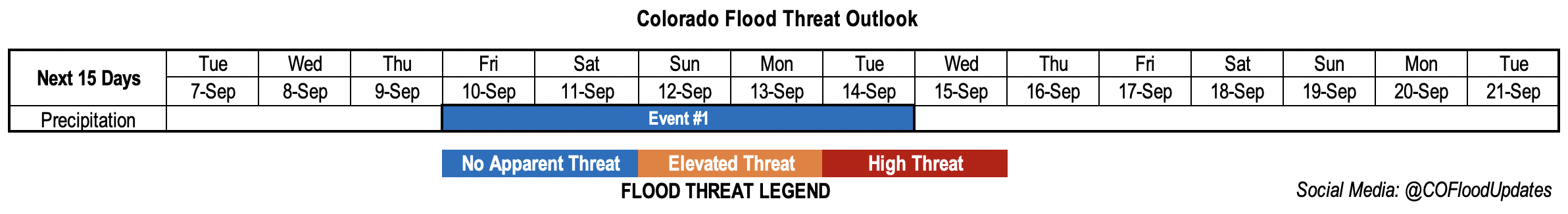
Valid Dates: 9/7 – 9/21
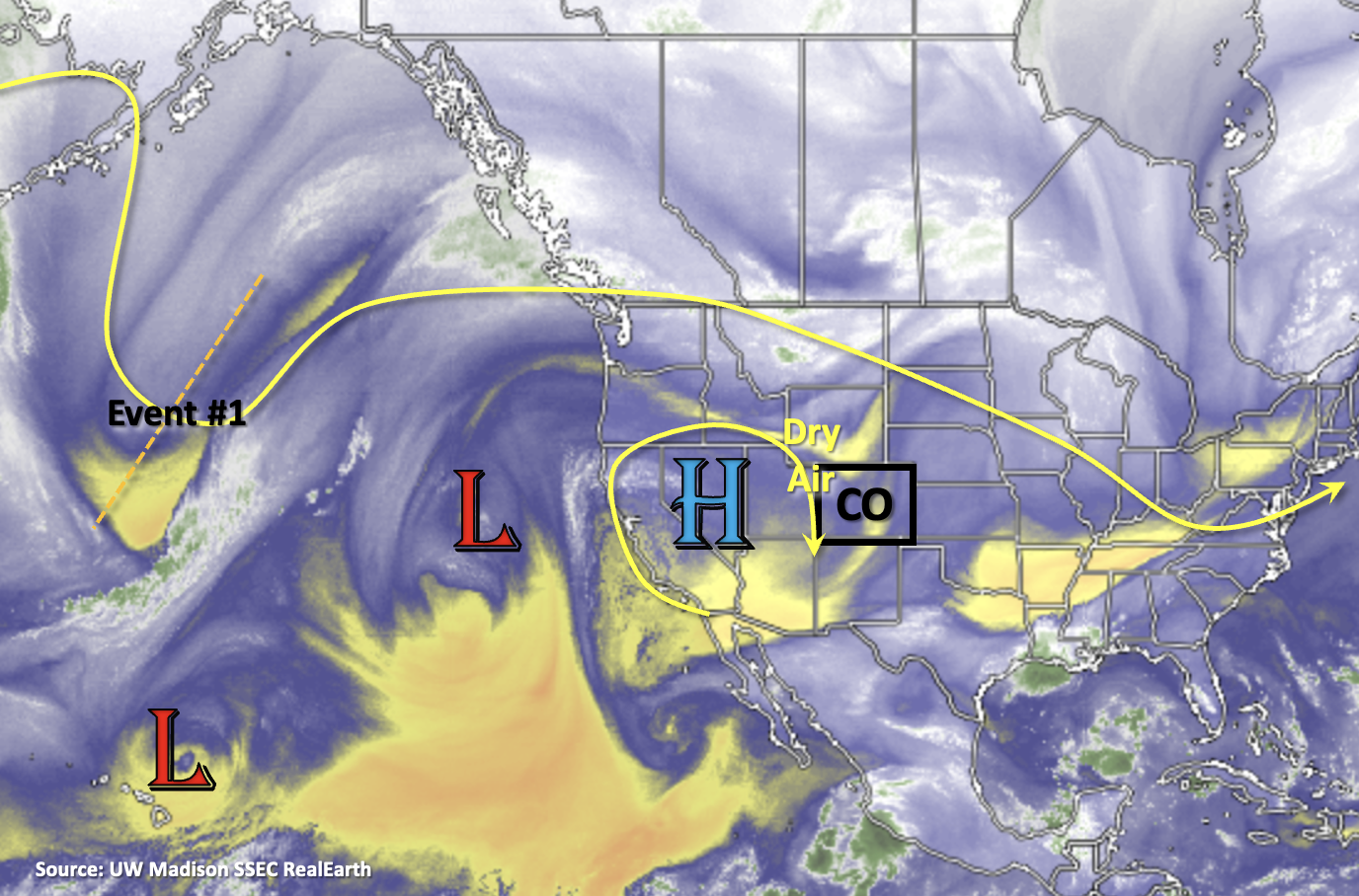
A rain-free work week is ahead now that dry air has worked its way over the state and will be held in place by the High, marked below. This High is forecast to strengthen over the next couple of days, which will promote hot, September temperatures under a ridging pattern. There’s a peak in the hot weather on Thursday and Friday, and several daily temperature records could be broken along the Front Range, San Luis Valley and perhaps over the Grand Valley (forecasts here). It isn’t until the end of the week that the trough marked below begins to break down the ridge and suppress the High further south. A couple cold fronts and weak subtropical moisture are expected to help return a little moisture to the state for some potential storm development over the mountains and adjacent plains this weekend and into next week (Event #1). The first front on Saturday should help cool down temperatures 5-8F, depending on your location. Then, there looks to be a stronger cold front that comes through on Monday, which could (potentially) be our first taste of fall.
With PW well below average throughout the week, it isn’t likely there will be much, if any rainfall for the state. While there may still be some mild pockets of moisture remaining, subsidence under the ridge will like squash the chances of storm development. Best chance for a stray shower or two will be over the southern high terrains during this period. Fire danger will also increase some during this week, especially west, where it gets very dry and hot. Thankfully, it still looks like there will be light surface winds, which could somewhat mitigate the danger. PW rises behind the trough’s passage over the weekend, which should return scattered storms to the forecast. Lack of boundary layer moisture is a concern, which could increase fire danger over the mountains/mesas if storms develop (lightning with little to no rain reaching the surface). The lack of surface moisture along with faster westerly steering flows should keep the flood threat minimal, so at this time there is No Apparent flood threat issued for this event.

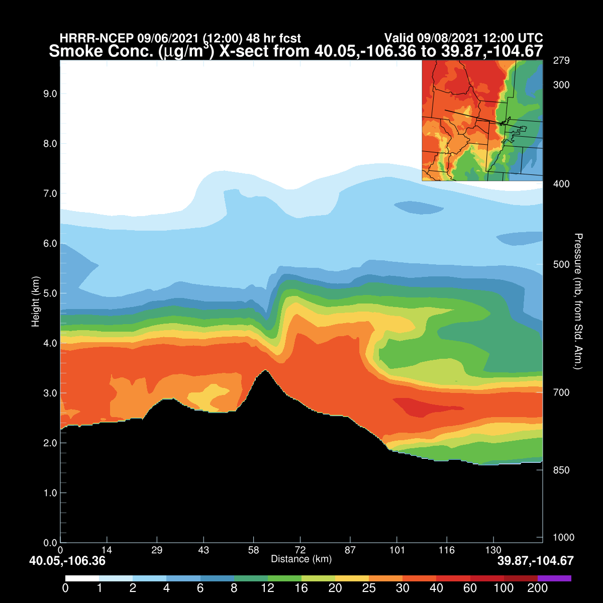
It’s also going to get rather smoky for some over the next 48-hours. Increasing northerly winds will continue to pull in the heavier smoke that’s been sitting just north of our border, so lower and lower visibility is anticipated. This is especially true over northwest and central western Colorado. Below is a cross section from DIA (right side) to central Grand County (left) that cuts through Boulder County issued this morning that is valid for Wednesday morning. Concentration of the smoke should be high enough that Air Quality Alerts will likely be issued, so be sure to tune into your local news station for the latest.
Event #1: Friday – Tuesday (9/10 – 9/14)
Minimal moisture return behind a couple cold fronts should return the chances for scattered storms, but No Apparent flood threat is issued.
As mentioned above, not sure how much surface moisture will be present heading into this weekend, which means storms may produce more wind and dangerous lightning than rainfall. These initial weekend storms could help set the stage for some more moderate rainfall rates Monday and Tuesday, if they can help moisten the boundary layer some. This is more likely east than west. At this time, flooding is not anticipated during Event #1. Rainfall totals should be highest over the northern high terrains, along and east of the Continental Divide. Additional storms and rainfall may be possible over the plains from the frontal passages. Faster steering flows should keep rainfall totals on the lower end.