Issue Date: Thursday, September 9th, 2021
Issue Time: 12:45PM MDT
Valid Dates: 9/10-9/24

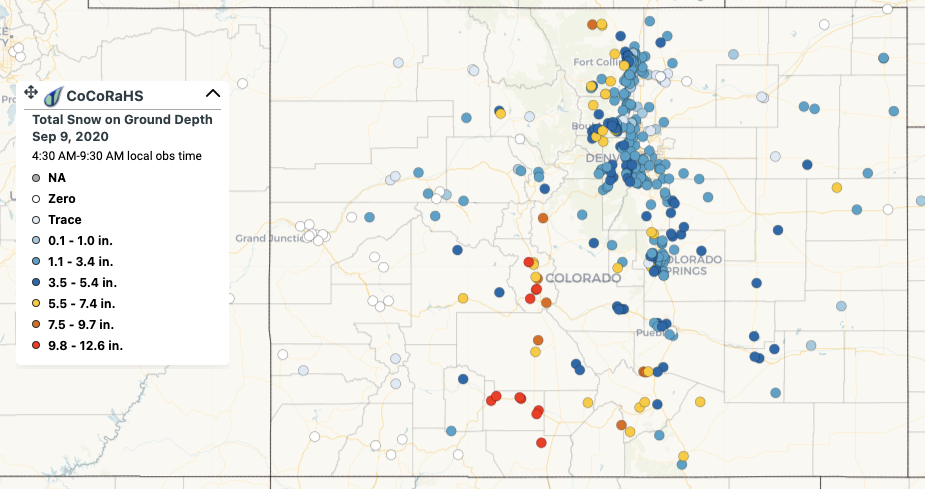
On the morning of September 9th, exactly one year ago, most of Colorado awoke to find rare but significant early-season snowfall accumulation even for lower elevation locations (see CoCoRaHS map below). However, in the prelude to this event, the state experienced a 72-hour period of scorching weather with an all-time high September record of 101F set in Denver on September 5th.
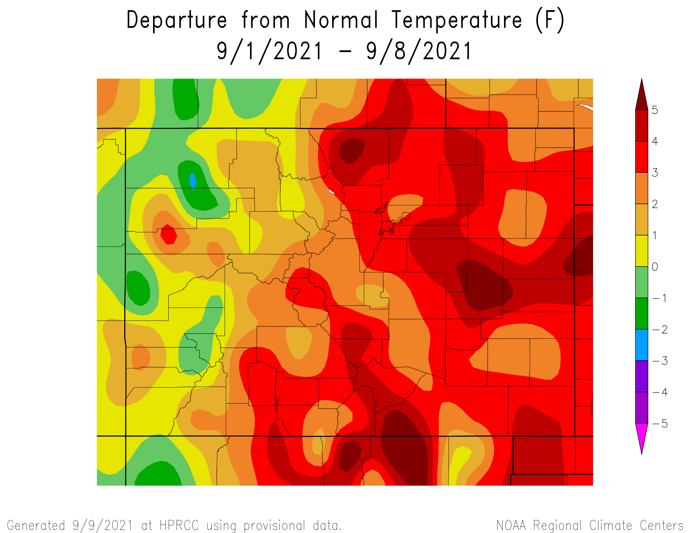
Fast forward to now, and we see at least one similarity to 2020: the notable September heat (and just to be clear: no snow is coming!). As shown below, central and eastern Colorado have started the first week of September 2021 up to 5F above normal. This metric will rise sharply in the next few days as more near-record or even record heat is expected, amidst the background of declining seasonal normal temperatures.
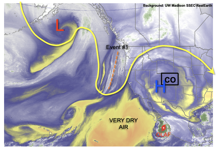
As shown in the water vapor image, below, the culprit behind the current heat is the combination of very dry air (i.e. limited cloud cover) over the southwest US (and in fact extending all the way into the eastern Pacific Ocean), as well as strong ridging aloft. This ridge will hold its ground for roughly the next 48-72 hours, before somewhat succumbing to an incoming trough currently entering the US West Coast. However, the trough’s dynamics will weaken considerably as it moves closer to Colorado, so only isolated to scattered showers and thunderstorms are currently expected with this Outlook’s only precipitation event, Event #1.
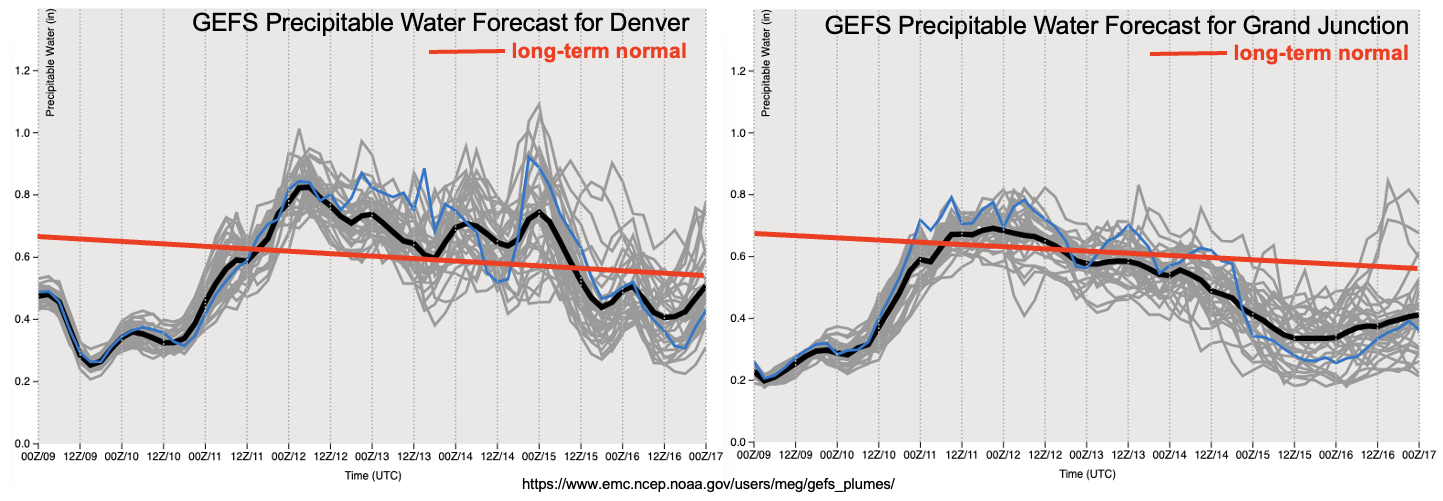
As shown in the forecasted Precipitable Water (PW) plumes, a significant increase in moisture is expected statewide, to values more in line with their mid-September average. Furthermore, there will be at least marginal instability beginning Saturday to support isolated thunderstorms. However, the main limitation to rainfall will be strong steering flow, which will make it difficult to accumulate more than 0.5 inches of rainfall in any given location.
By the early and middle portion of next week, a larger trough will setup over the Pacific northwest. For Colorado, this implies generally southwest steering flow and the continued import of dry Pacific air (also seen well in the PW forecasts above). Temperatures will cool off a bit by Monday, but are likely to hover at least slightly above seasonal normal for most of next week. One interesting caveat to this forecast is the eventual fate of Hurricane Olaf. This storm will soon enter much more unfavorable conditions in the form of dry air. However, if it can stick around long enough into next week, some guidance is suggesting a modest pulse of monsoonal-type moisture. At this time, this would be quite the improbable outcome, but still, something interesting to watch.
The identified precipitation event is described in more detail below.
Event #1: Saturday – Tuesday (September 11 – September 14)
Isolated Storms Possible Through Period, But No Apparent Flood Threat
Daily rounds of isolated to widely scattered showers and thunderstorms are possible mainly over northern Colorado, north of I-70. The best coverage will likely be over the higher terrain (especially Northern Mountains and Front Range). However, some activity could occur even over the eastern plains. Max 1-hour rainfall up to 0.5 inches is possible with this event, although this would be over very isolated areas. With strong steering winds in place, only a few tenths of rainfall are expected over most locations that are lucky enough to see rainfall. Thus, no precipitation map is needed at this time.