FTO 09-30-2021: Warm Start To October With A Few Rain Events, Followed By Possible Major Pattern Change By Mid-Month

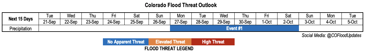
Issue Date: Thursday, September 30th, 2021
Issue Time: 3PM MDT
Valid Dates: 10/1-10/15

Note: This is the final Flood Threat Outlook of the 2021 forecast season. The program is scheduled to return on May 1, 2022. It has been a pleasure to serve the state of Colorado!

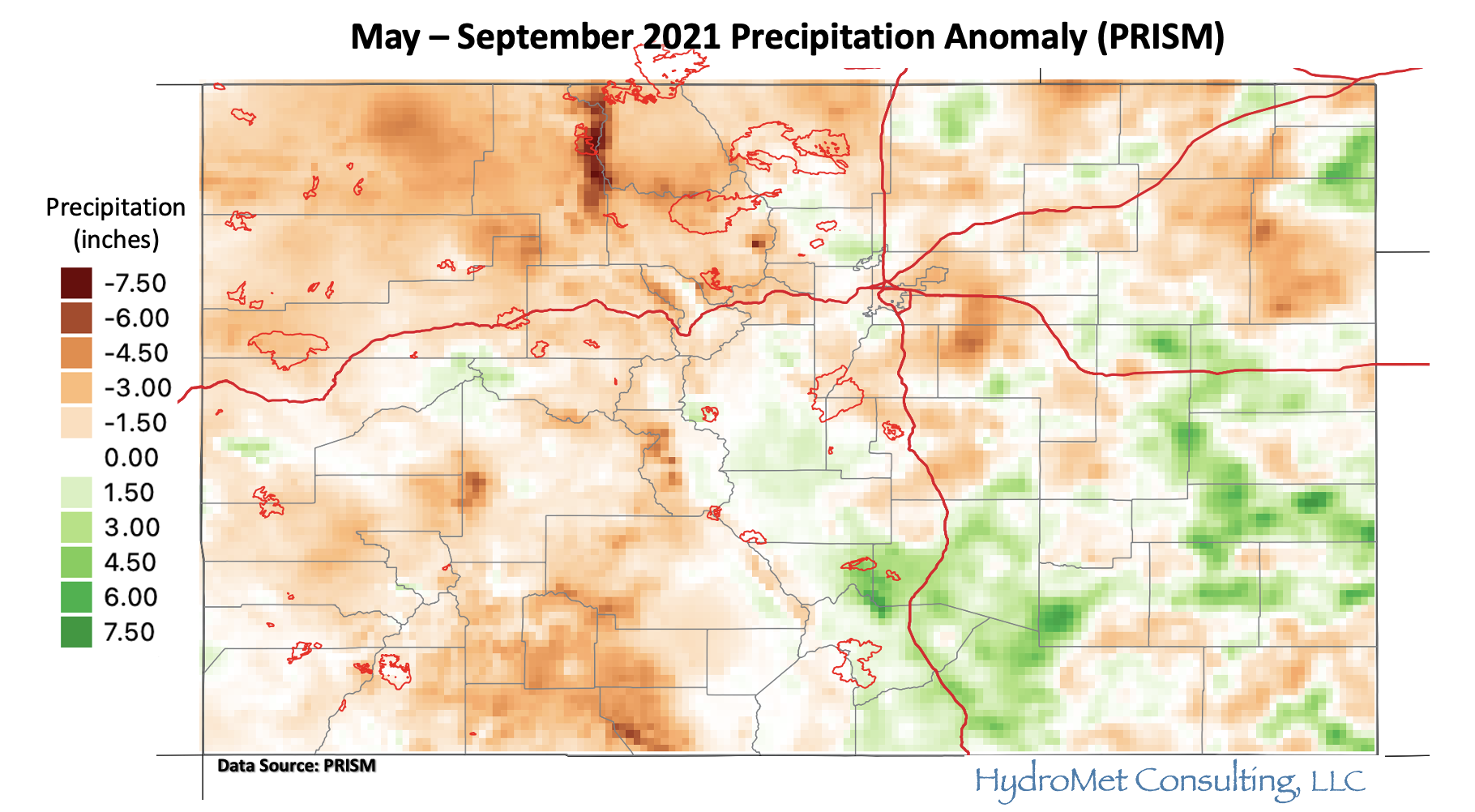
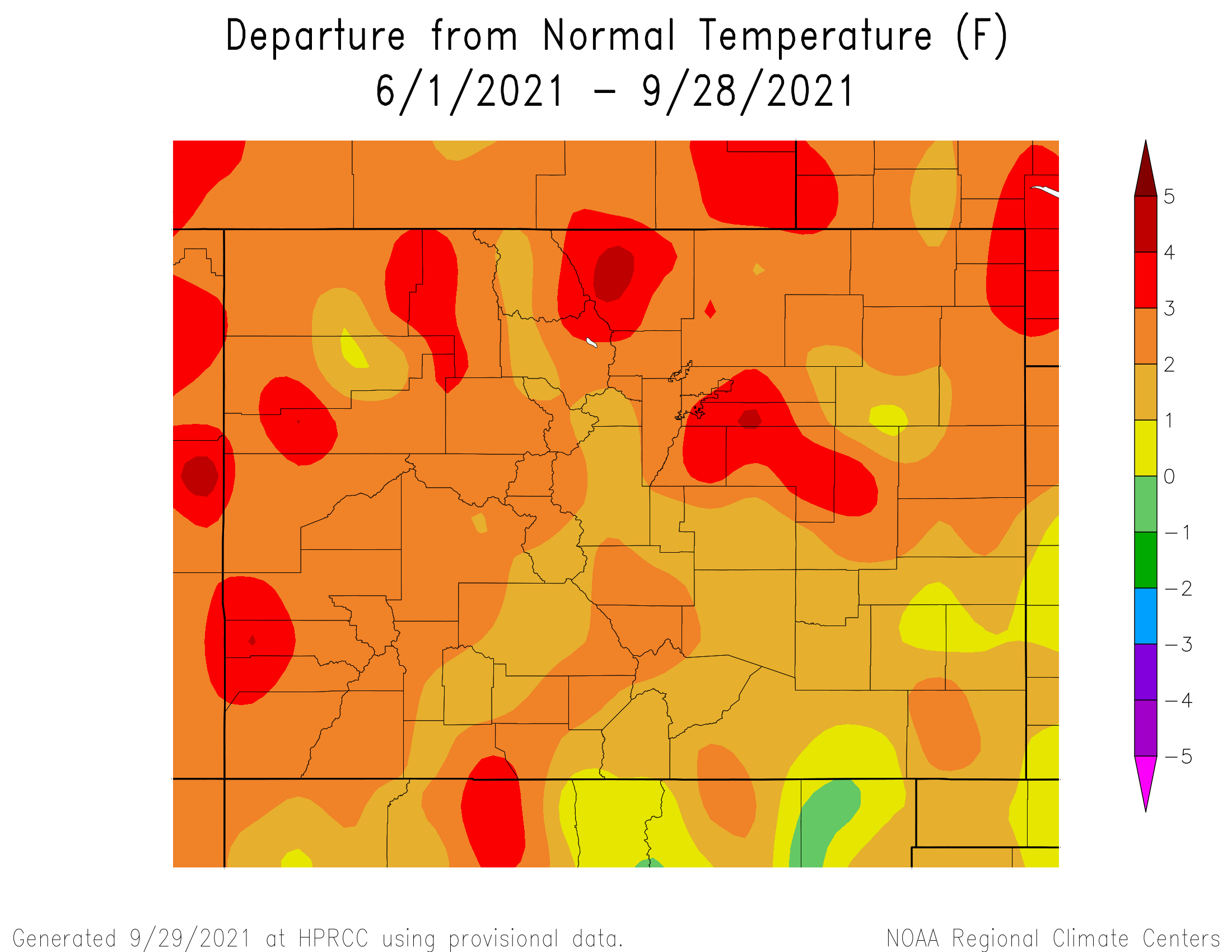
Fall-like weather has finally overtaken most of Colorado after a seemingly endless Indian Summer. Denver will very likely finish the season with 59 days above 90F, or the fifth highest total since records began in the 1870s. Pueblo looks to finish with 85, also the fifth highest total since records started around 1890. Across the Continental Divide, Grand Junction will likely finish with 78 days above 90F, or tied for the ninth highest total since records began in the 1890s. Below, we see that, in consistency with the 90 degree day counts and our perception, summer has been very warm with the entire state running above average. Large parts of the state have seen temperatures of 2F or more above normal over a 120-day stretch, certainly a noteworthy signal of heat.

If we zoom out a bit, okay perhaps more than a bit, to the entire planet, below we see anomalies of Outgoing Longwave Radiation (OLR) since early July (roughly the start of monsoon season). Positive anomalies essentially imply “sunnier” than normal conditions where the atmosphere is emitting more radiation than normal, to space. Negative values imply the opposite, and generally coincide with more cloudy conditions. We can see that most of the western United States saw above normal OLR, with the very small sliver of negative values over the Gulf of California representing the significantly above normal monsoon over parts of AZ and NM.

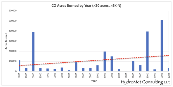
When we consider the observations above, it is perhaps a bit surprising that our wildfire activity was not as active as in previous years. Below, we see that higher-elevation burn acreage in 2021 will (likely) end up much below the normal value of the past two decades. However, keep in mind that this “average” includes some extraordinary years such as 2020 and 2018, so there is a case to be made that 2021 was still likely above the longer-term normal value (i.e. if we extend the record back before 2000; however, data quality becomes more suspect). Regardless, we are not complaining!

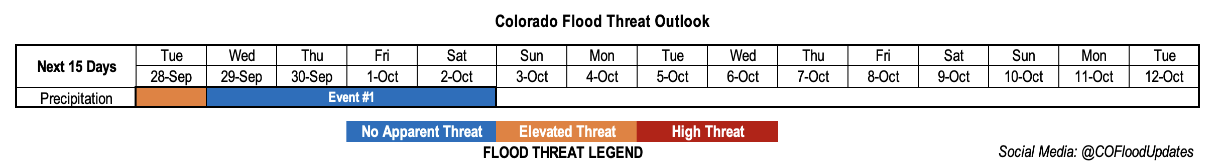
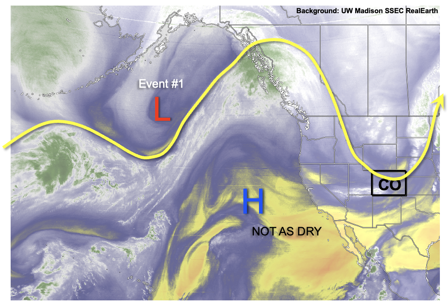
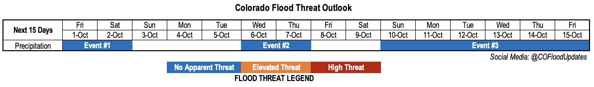
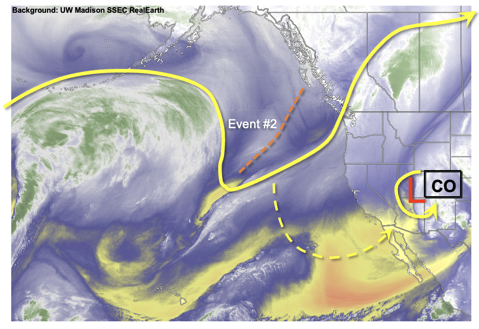
Now let’s shift the focus back to the Outlook, the final one of the 2021 season. As seen in the water vapor imagery below, we are currently experiencing an active weather pattern with a disturbance traversing the state. This disturbance will cause rain and snow across mainly southern Colorado through Saturday (Event #1). Although a few weaker thunderstorms are possible, only short-term moderate intensity rainfall is expected and there is No Apparent Flood Threat. Instead the San Juan Mountains, San Luis Valley, Southeast Mountains, Raton Ridge and Southeast Plains will experience very welcomed, widespread precipitation.

After the passage of Event #1, an upper-level ridge will develop over the northern Great Plains, with Colorado lying on its western periphery. To the west, an incoming trough will have a hard time progressing into the ridge, and a large part of it will split from the flow. This cut-off will take it’s sweet, old time to make it into Colorado, but it will eventually, along with at least a brief surge of monsoonal-type moisture. With warmer temperatures, perhaps 5F-8F above seasonal normal, a widespread predominantly-rain event is expected for the Western Slope (Event #2). Certainly welcome news! Isolated moderate-intensity rainfall is also appearing more likely with this event, but there is currently No Apparent Flood Threat as instability will be minimal.

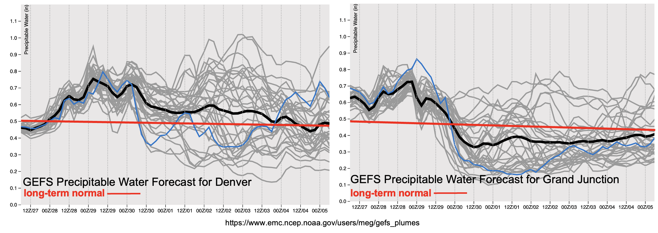
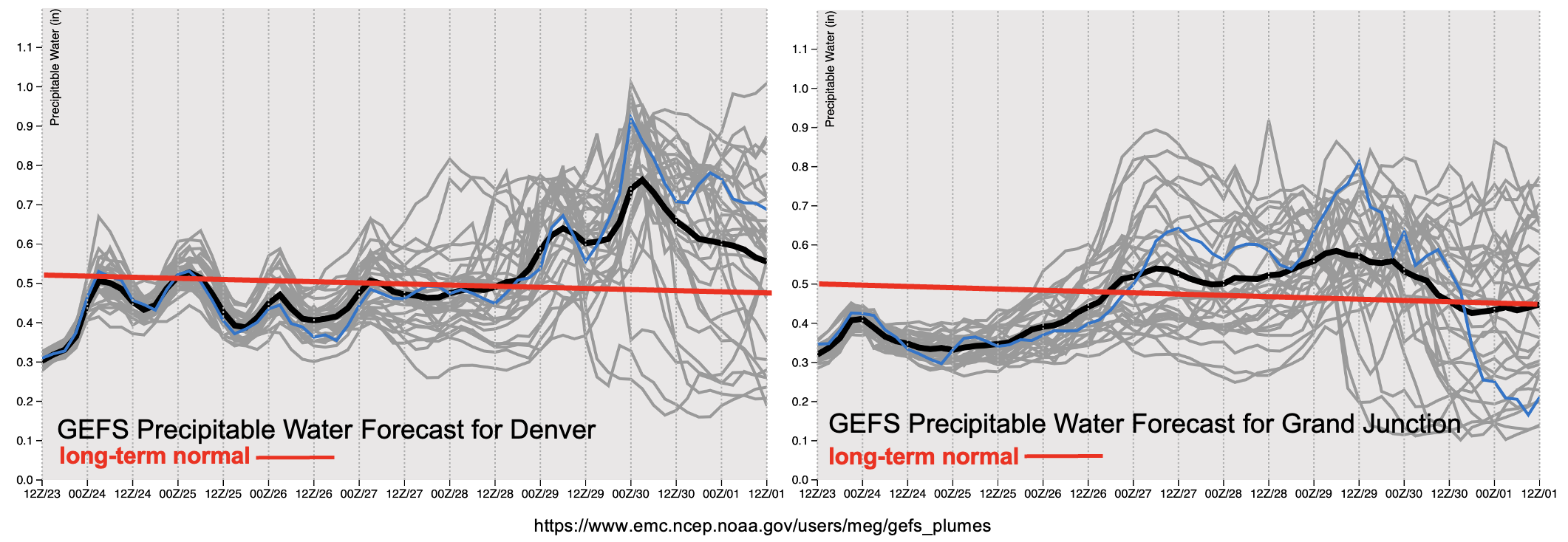
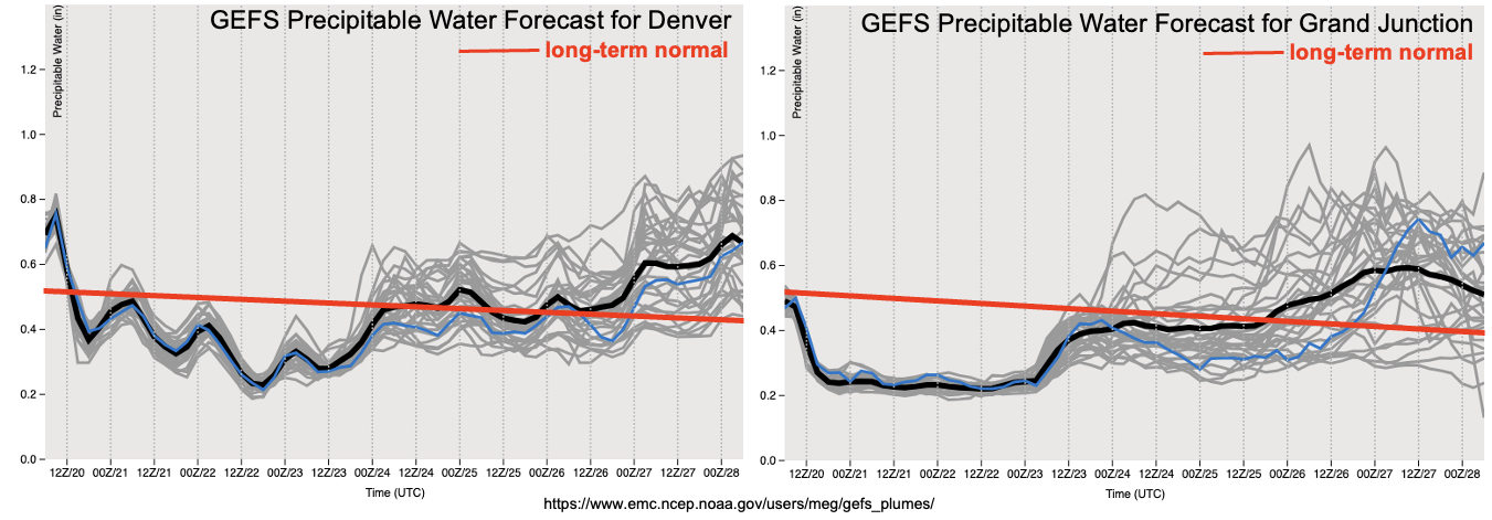
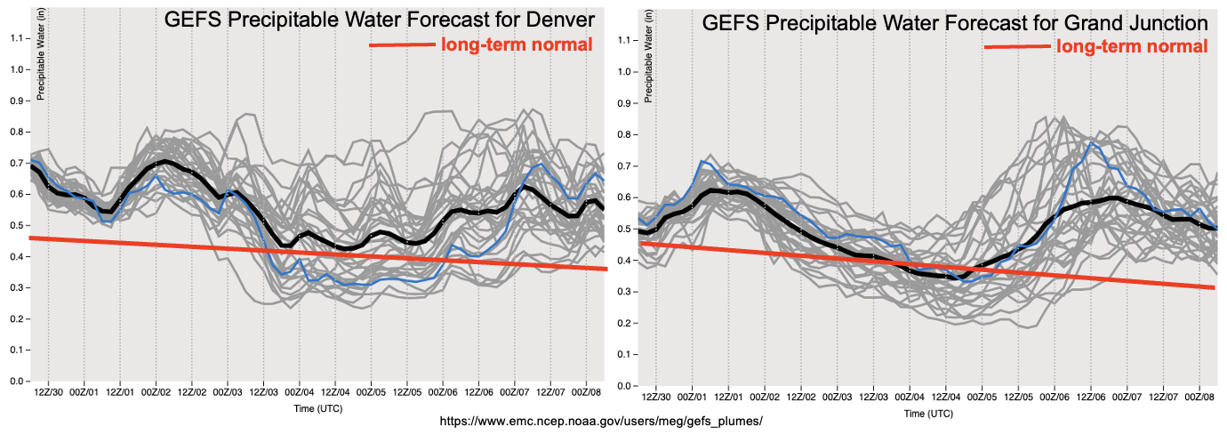
The weather looks to get more interesting after the passage of Event #2, starting roughly around October 10th. Guidance is showing a strong consensus suggesting the breakdown of the Great Plains ridge, and a development of a large western United States trough (Event #3). As shown in the Precipitable Water (PW) plumes, below, even after the passage of Event #2, PW is expected to remain largely above average across the state. With large-scale synoptic forcing, and moist upslope flow, we are likely to see the repeated, widespread accumulating snow over the entire higher terrain. Lower elevation precipitation chances also look to be above average, although the total amounts are currently expected to remain below 0.5 inches. As can be expected with the cooler conditions, instability will be minimal or non-existent so there is No Apparent Flood Threat with this event either.

The identified precipitation events are described in more detail below.

Event #1: Friday – Saturday (October 1 – October 2)

Widespread Rain, Weaker Storms And High-Elevation Snow For Southern Colorado, But No Apparent Flood Threat

An active Friday is expected over southern and southeastern Colorado as the disturbance moves across. Widespread rain and snow showers are expected over the San Juan Mountains, San Luis Valley, Southeast Mountains and Raton Ridge where up to 1 inch of storm total precipitation will be possible. Isolated weak thunderstorms cannot be ruled out in this region. Significant high-elevation snow is expected, especially over the Sangre de Cristo mountains where over 1 foot could accumulate by late Friday.

Further east towards the OK/KS border, more convective activity is expected amidst the steady rainfall, where max hourly rainfall up to 0.8 inches looks possible, along with storm total precipitation in the 1-1.5 inch range locally.

Isolated higher terrain rain and snow showers could continue into Saturday, though with little meaningful accumulation.

Event #2: Wednesday – Thursday (October 6 – October 7)

Showers and Weaker Storms Possible Over Western Slope, But No Apparent Flood Threat

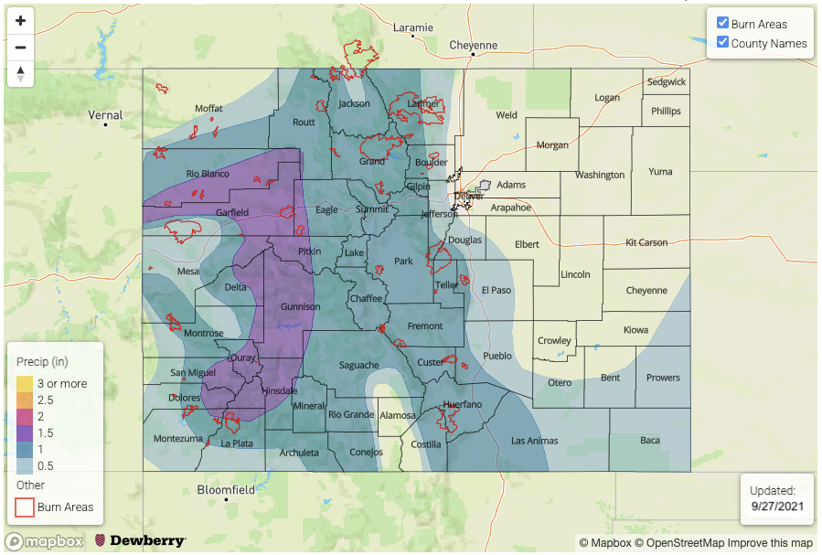
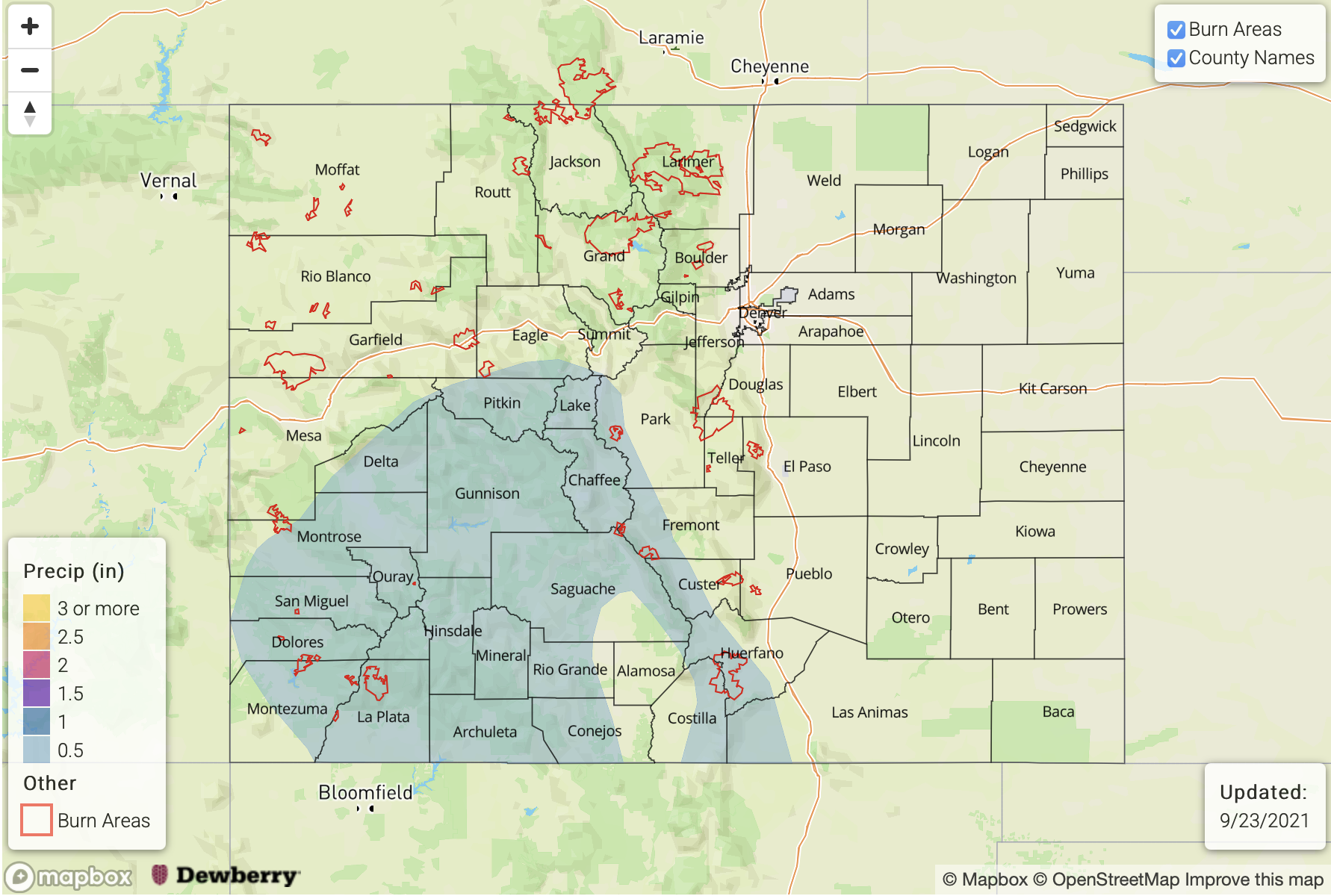
Another cut-off low will push a weak monsoonal surge into western Colorado, fueling a 24 to possibly 48-hour period of precipitation activity on Wednesday-Thursday. At this time, max 1-hour rainfall up to 0.7 inches looks to be possible, although this will be very isolated in nature. However, the Pine Gulch and Grizzly Creek burn scars could be affected. Overall, a widespread 0.5 to 0.8 inches of precipitation is expected across the Western Slope.

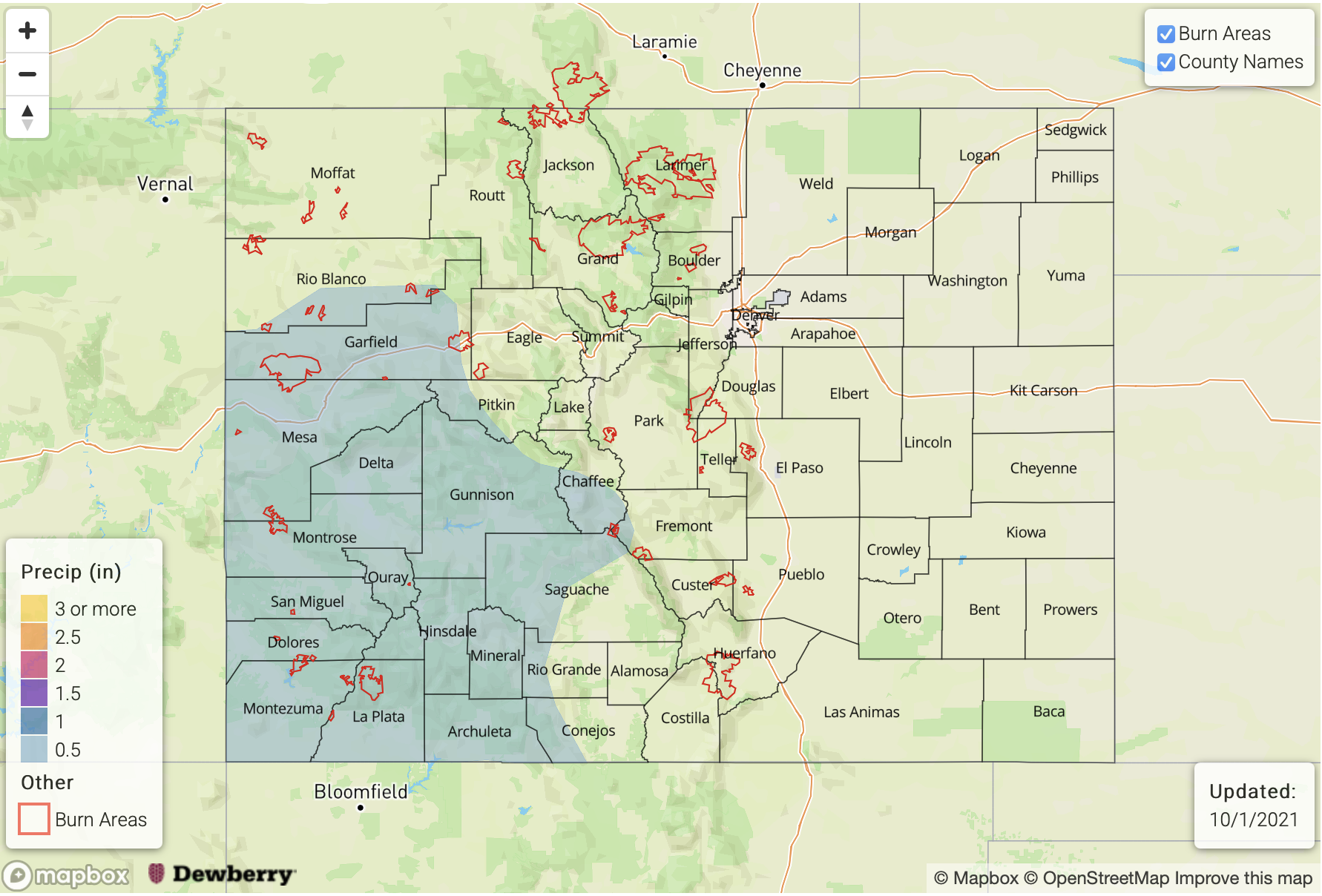
Event #3: Sunday – Friday (October 10 – October 15)

Cooler Conditions Expected With Frequent Rain/Snow; No Apparent Flood Threat

Cooler conditions are expected to develop by Sunday, October 10, with temperatures expected to run at least 5F below normal for the foreseeable future. At least several pulses of precipitation are expected, though this will mainly be in the form of higher elevation upslope rain and snow showers. At this time, perhaps up to 0.5 inches will be possible through the course of the event. Thus, no precipitation map is provided.

FTO 09-27-2021: One Day Elevated Threat with One More Widespread Precipitation Event for Our Forecast Season

Issue Date: Monday, September 27th, 2021
Issue Time: 3PM MDT
Valid Dates: 9/28 – 10/12

Event #1 started a little bit earlier than anticipated in last week’s FTO. The moisture plume, associated with the cutoff Low, turned out to be on the stronger side. Paired in with an increase in dynamics as the cutoff Low moved to the northeast, the convective potential for rainfall increased today. The Low should continue to hold this higher moisture in place over the next 24-hours as the next trough moves east, marked below. As the trough approaches tomorrow afternoon, if another day with decent instability can develop, we may see another day with convective potential over western Colorado. Thus, the one-day Elevated flood threat.

After Tuesday, cooler temperatures are expected behind a cold front as the base of the trough moves over the state. At this time, we expect to see more rain turn to snow over the mountains with the far eastern plains becoming more stable (no rainfall). With more gradual rainfall and snow forecast for Wednesday over the mountains and immediate adjacent plains, there is No Apparent flood threat issued.

Thursday into Saturday, it looks like the state could be influenced by some mid-level energy that gets cut off from the main trough axis. With the mid-level energy sitting just south of the state, and some residual moisture over the area, it’s likely that light showers and some snowfall will continue over the mountains. Expect a decrease in the coverage of precipitation from Thursday into Saturday.

PW plumes from the GEFS do a good job of showing this moisture surge hanging on through Wednesday (west) and Thursday (east). It looks like a very dry air mass will begin to fill in over western Colorado after Wednesday, so with that scenario being likely, widespread precipitation should become more scattered and favor areas south for accumulation. There is much more of a spread in PW potential east after Friday/Saturday (spacing of gray lines). This has to do with the uncertainty in the location and strength of the vorticity maximum that cuts off during the trough’s passage. Generally, we can probably expect a decrease in PoPs over the mountains heading into next week. Be sure to tune into the last FTO of this season on Thursday, as there will likely be more consensus in the EPS and GEFS solutions heading into the first full week of October.

Below is a quick look at the precipitation anomaly during the warm season (May to September) through yesterday. This 4km dataset is from the PRISM group, which uses a climatology from 1981-2010. Portions of the Northeast Plains are quite dry after a much above normal precipitation to record wet May. It is likely that the lack of precipitation in July and August contributed a lot to these below average totals. It’s also been very dry over the majority of western Colorado, especially near the Jackson/Routt County line according to the dataset. It’s no surprise that the Morgan Creek fire started in the area after experiencing much below normal precipitation during May and June, and it was likely hard to contain with very dry fuels. As pointed out in the SPM a few days back, the northwest corner of the state is under D3 (Extreme) to D4 (Exceptional) drought conditions. This isn’t a huge surprise as precipitation anomalies are generally 3 to 6 inches below normal during the period shown below, and this image doesn’t include the very dry April over the region. The one positive takeaway from the map below is that despite the large area of below average rainfall over western Colorado and the mountains, it was a relatively quiet fire season; especially when compared to last year.

It looks like the Wet Mountains and Raton Ridge had a good warm season on the precipitation front as well as portions of the Southeast Plains. August was a big rainfall month for the Raton Ridge area, which likely helped boost the well above average anomalies seen below.

Event #1: Tuesday – Saturday (9/28 – 10/2)

ELEVATED/NO APPARENT flood threat is issued as the next trough moves through into an area with elevated moisture.

Event #1 could be a great accumulation event for portions of western Colorado and the mountains. Outside of the potential for a little convection and training storms tomorrow, more gradual rainfall and some snow will limit the flood threat. After Tuesday, precipitation will begin to move east with the base of the trough. It will likely be too stable for much, if any, rainfall over the eastern plains, but some moderate accumulations are possible for the Front Range, Southeast Mountains and adjacent plains. This is especially true over the elevated ridges, where a little more convergence is likely to develop. While it looks like snow will be falling over the highest peaks, especially after Tuesday, not quite sure what level the snow line will fall to. Be sure to tune into the FTB as these details can be better tracked in a real-time forecast operations.

FTO 09-23-2021: Warm & Dry Through the Weekend with Precipitation Chances Returning Next Week

Issue Date: Thursday, September 23rd, 2021
Issue Time: 3PM MDT
Valid Dates: 9/24 – 10/8

Despite a cold front moving through the state tonight, there will be little change in the overall availability of moisture. So, at this time, not anticipating any meaningful post-frontal rainfall tomorrow, just a drop in overall temperatures a few degrees. The trough to our west (marked below) will likely become cut off from the main flow over the next 24-hours. This disturbance looks like it will linger to our southwest for the next several days as a ridging pattern builds over the area. Through this weekend, that ridging pattern should be the dominate weather feature and return above average temperatures and dry conditions to the state. There may be some breezy conditions over the northern mountains and eastern plains during this period, which could increase fire danger through early next week. It isn’t until late Monday into Tuesday when the weather gets interesting again.

It is likely that this cutoff Low/vorticity maximum will pull some subtropical moisture northward by early next week. This should increase the chances of precipitation by early next week across the southern high terrains, particularly west. As the next trough arrives by mid-week, extra dynamics may interact with a (potential) moisture surge over Colorado. Thus, Event #1 is extended into the first weekend of October.

There’s a lot of uncertainty with Event #1 for a couple of reasons. One, it’s hard to tell where the mid-level energy will move early next week and how much subtropical moisture it will help pull northward. Additionally, models are not in agreement with the strength or exact location of the next large incoming trough and its ability to tap into elevated moisture. This uncertainty within the forecast can be seen in the PW plumes below by the separation of the gray lines (ensemble members) after this weekend.

Generally speaking, there does look like there will be an overall increase in moisture both east and west with Event #1, but the magnitude of the PW surge remains unknown. This places a lot of uncertainty in the QPF totals and placement of precipitation. Next Thursday could also get interesting over the Urban Corridor and adjacent plains as a cold front may slide south during the afternoon hours. At this time, there is No Apparent flood threat issued as it is unlikely, that this late in the season, decent instability will be able to build for more vigorous thunderstorms and higher rain rates. Nonetheless, Event #1 bears watching, so be sure to tune back into the FTO on Monday for the latest details.

Event #1: TuesdaySaturday (9/2810/2)

NO APPARENT flood threat is issued as a trough interacts with minimal subtropical moisture.

Currently, Event #1 is looking like there could be decent accumulation over the southwest corner of the state starting early next week. The magnitude of the moisture surge will directly affect the totals, but isolated areas of the San Juan Mountains could see up to 1 inch of precipitation, if the surge is strong enough. It dries out fairly quickly over the northwestern portion of the state with the arrival of the next trough, but that’s when the precipitation chances shift eastward. There’s more uncertainty with QPF over the eastern portion of the state Thursday into the weekend. We’ll continue to keep an eye on the event as Thursday shows some potential for thunderstorm development. It is likely that this will be more of a stratiform rainfall event due to the fact it is already October and instability typically begins to drop off. So, at this time there is No Apparent flood threat issued. As far as snowfall chances, only a handful of the GEFS members have snow falling over the mountains Wednesday into Thursday at this time.

FTO 09-20-2021: Late Summer Heat To Return; Wet Pattern Looking More Likely Next Week

Issue Date: Monday, September 20th, 2021
Issue Time: 12PM MDT
Valid Dates: 9/21-10/5

During the last Outlook, we mentioned the small possibility that a monsoonal plume would increase precipitation chances across Colorado beginning next week. This is looking significantly more likely now, and a welcomed prolonged period of above normal precipitation should provide many with some beneficial moisture (Event #1). However, this is jumping to conclusions, so let’s discuss how this could arise.

As shown in the water vapor image, below, a highly amplified jet stream is noted this morning across the central/eastern Pacific as well as North America. As described in this morning’s FTB, the current strong trough overhead will significantly cool off the entire state. However, this is a transient feature that will quickly move east and be replaced by a ridge. The primary end-product of this will be a return to much above normal temperatures. In fact, above normal temperatures, to the tune of 5-10F, are essentially expected through the rest of this Outlook as the aforementioned ridge moves eastward and parks itself over the central United States. At the same time, a strong trough will develop off the western North American coast resulting in southwesterly steering flow over Colorado. Interestingly, the eastern subtropical Pacific has moistened up a bit, after being very dry in the past 2 weeks or so. Thus, after a very dry week this week, moisture will return to Colorado, and likely stick around for awhile.

As shown in the Precipitable Water (PW) plumes, below, moisture will nosedive to below seasonal average statewide, but especially over the Western Slope. Coupled with increasingly higher temperatures this week, there could be a day or two with a wildfire threat. However, currently this looks to be mitigated by rather weak boundary layer winds. By later this week, moisture increases to near seasonal normal, and then above seasonal normal over the weekend. Although a return to precipitation is looking likely, the nature of the precipitation is highly uncertain given that heavy rainfall is becoming quite unlikely from a climatological perspective. Factors that could produce a low-end Elevated flood threat for a day or two would be the existence of a cut-off low that is being forecasted by some guidance. However, for now, the more likely outcome is light to moderate precipitation, with at least some weaker thunderstorms expected especially earlier in Event #1. Thus, there is No Apparent Flood Threat at this time, although this could change in the upcoming Outlooks.

The identified precipitation event is described in more detail below.

Event #1: Monday – Saturday (September 27 – October 2)

Precipitation To Return, But No Apparent Flood Threat At This Time

Scattered precipitation could return by next weekend, but guidance is currently suggesting that the best chances will arrive by Monday, 9/27. At this time, it appears that the southwest quadrant of the state will see the best chances of precipitation exceeding 0.5 inches. However, with the likelihood of frontal passages, the entire state could see lighter precipitation up to 0.5 inches. The best chances of convective rainfall currently appear to be early in Event #1, from Monday through Wednesday when intensity exceeding 0.5 inches per hour could occur. Thereafter, cooler temperatures could reduce instability and favor more gentler precipitation rates, and higher elevation snowfall. Overall, given that heavy rainfall is quite unusual this late in the season, and with the absence of a clear dynamical feature, we are currently not expecting a flood threat with this event.