Issue Date: Monday, September 27th, 2021
Issue Time: 3PM MDT
Valid Dates: 9/28 – 10/12
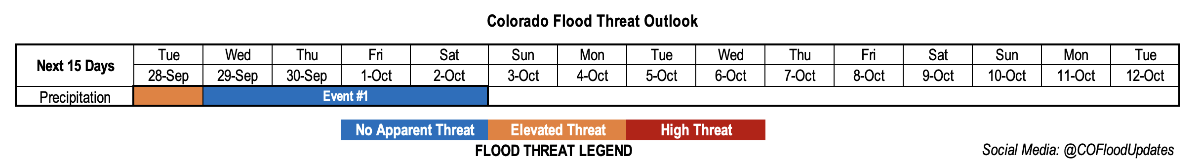
Event #1 started a little bit earlier than anticipated in last week’s FTO. The moisture plume, associated with the cutoff Low, turned out to be on the stronger side. Paired in with an increase in dynamics as the cutoff Low moved to the northeast, the convective potential for rainfall increased today. The Low should continue to hold this higher moisture in place over the next 24-hours as the next trough moves east, marked below. As the trough approaches tomorrow afternoon, if another day with decent instability can develop, we may see another day with convective potential over western Colorado. Thus, the one-day Elevated flood threat.
After Tuesday, cooler temperatures are expected behind a cold front as the base of the trough moves over the state. At this time, we expect to see more rain turn to snow over the mountains with the far eastern plains becoming more stable (no rainfall). With more gradual rainfall and snow forecast for Wednesday over the mountains and immediate adjacent plains, there is No Apparent flood threat issued.
Thursday into Saturday, it looks like the state could be influenced by some mid-level energy that gets cut off from the main trough axis. With the mid-level energy sitting just south of the state, and some residual moisture over the area, it’s likely that light showers and some snowfall will continue over the mountains. Expect a decrease in the coverage of precipitation from Thursday into Saturday.

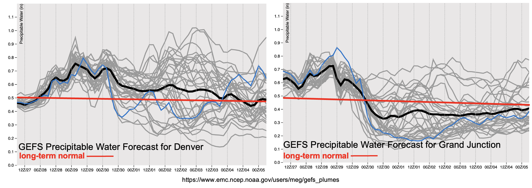
PW plumes from the GEFS do a good job of showing this moisture surge hanging on through Wednesday (west) and Thursday (east). It looks like a very dry air mass will begin to fill in over western Colorado after Wednesday, so with that scenario being likely, widespread precipitation should become more scattered and favor areas south for accumulation. There is much more of a spread in PW potential east after Friday/Saturday (spacing of gray lines). This has to do with the uncertainty in the location and strength of the vorticity maximum that cuts off during the trough’s passage. Generally, we can probably expect a decrease in PoPs over the mountains heading into next week. Be sure to tune into the last FTO of this season on Thursday, as there will likely be more consensus in the EPS and GEFS solutions heading into the first full week of October.
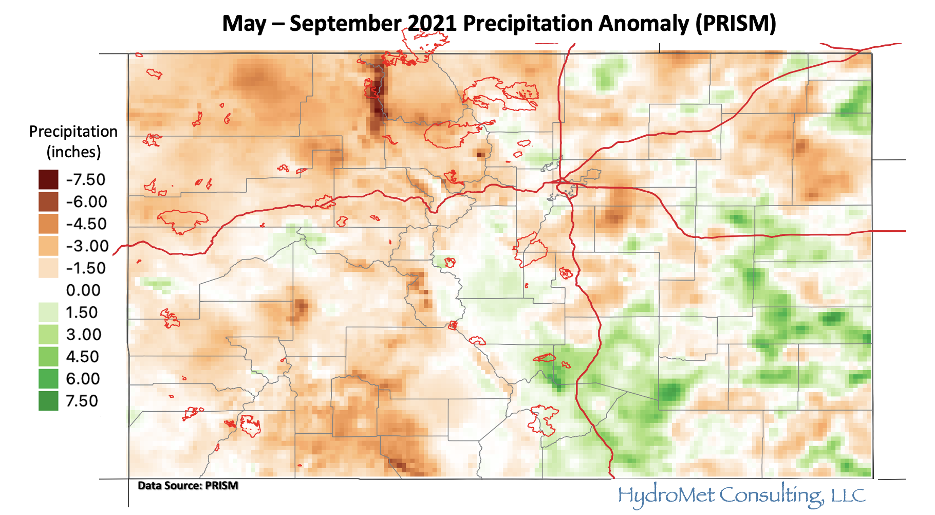
Below is a quick look at the precipitation anomaly during the warm season (May to September) through yesterday. This 4km dataset is from the PRISM group, which uses a climatology from 1981-2010. Portions of the Northeast Plains are quite dry after a much above normal precipitation to record wet May. It is likely that the lack of precipitation in July and August contributed a lot to these below average totals. It’s also been very dry over the majority of western Colorado, especially near the Jackson/Routt County line according to the dataset. It’s no surprise that the Morgan Creek fire started in the area after experiencing much below normal precipitation during May and June, and it was likely hard to contain with very dry fuels. As pointed out in the SPM a few days back, the northwest corner of the state is under D3 (Extreme) to D4 (Exceptional) drought conditions. This isn’t a huge surprise as precipitation anomalies are generally 3 to 6 inches below normal during the period shown below, and this image doesn’t include the very dry April over the region. The one positive takeaway from the map below is that despite the large area of below average rainfall over western Colorado and the mountains, it was a relatively quiet fire season; especially when compared to last year.
It looks like the Wet Mountains and Raton Ridge had a good warm season on the precipitation front as well as portions of the Southeast Plains. August was a big rainfall month for the Raton Ridge area, which likely helped boost the well above average anomalies seen below.
Event #1: Tuesday – Saturday (9/28 – 10/2)
ELEVATED/NO APPARENT flood threat is issued as the next trough moves through into an area with elevated moisture.
Event #1 could be a great accumulation event for portions of western Colorado and the mountains. Outside of the potential for a little convection and training storms tomorrow, more gradual rainfall and some snow will limit the flood threat. After Tuesday, precipitation will begin to move east with the base of the trough. It will likely be too stable for much, if any, rainfall over the eastern plains, but some moderate accumulations are possible for the Front Range, Southeast Mountains and adjacent plains. This is especially true over the elevated ridges, where a little more convergence is likely to develop. While it looks like snow will be falling over the highest peaks, especially after Tuesday, not quite sure what level the snow line will fall to. Be sure to tune into the FTB as these details can be better tracked in a real-time forecast operations.