Issue Date: Thursday, September 23rd, 2021
Issue Time: 3PM MDT
Valid Dates: 9/24 – 10/8

Despite a cold front moving through the state tonight, there will be little change in the overall availability of moisture. So, at this time, not anticipating any meaningful post-frontal rainfall tomorrow, just a drop in overall temperatures a few degrees. The trough to our west (marked below) will likely become cut off from the main flow over the next 24-hours. This disturbance looks like it will linger to our southwest for the next several days as a ridging pattern builds over the area. Through this weekend, that ridging pattern should be the dominate weather feature and return above average temperatures and dry conditions to the state. There may be some breezy conditions over the northern mountains and eastern plains during this period, which could increase fire danger through early next week. It isn’t until late Monday into Tuesday when the weather gets interesting again.
It is likely that this cutoff Low/vorticity maximum will pull some subtropical moisture northward by early next week. This should increase the chances of precipitation by early next week across the southern high terrains, particularly west. As the next trough arrives by mid-week, extra dynamics may interact with a (potential) moisture surge over Colorado. Thus, Event #1 is extended into the first weekend of October.

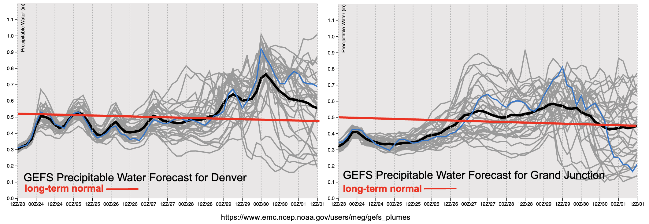
There’s a lot of uncertainty with Event #1 for a couple of reasons. One, it’s hard to tell where the mid-level energy will move early next week and how much subtropical moisture it will help pull northward. Additionally, models are not in agreement with the strength or exact location of the next large incoming trough and its ability to tap into elevated moisture. This uncertainty within the forecast can be seen in the PW plumes below by the separation of the gray lines (ensemble members) after this weekend.
Generally speaking, there does look like there will be an overall increase in moisture both east and west with Event #1, but the magnitude of the PW surge remains unknown. This places a lot of uncertainty in the QPF totals and placement of precipitation. Next Thursday could also get interesting over the Urban Corridor and adjacent plains as a cold front may slide south during the afternoon hours. At this time, there is No Apparent flood threat issued as it is unlikely, that this late in the season, decent instability will be able to build for more vigorous thunderstorms and higher rain rates. Nonetheless, Event #1 bears watching, so be sure to tune back into the FTO on Monday for the latest details.
Event #1: Tuesday – Saturday (9/28 – 10/2)
NO APPARENT flood threat is issued as a trough interacts with minimal subtropical moisture.
Currently, Event #1 is looking like there could be decent accumulation over the southwest corner of the state starting early next week. The magnitude of the moisture surge will directly affect the totals, but isolated areas of the San Juan Mountains could see up to 1 inch of precipitation, if the surge is strong enough. It dries out fairly quickly over the northwestern portion of the state with the arrival of the next trough, but that’s when the precipitation chances shift eastward. There’s more uncertainty with QPF over the eastern portion of the state Thursday into the weekend. We’ll continue to keep an eye on the event as Thursday shows some potential for thunderstorm development. It is likely that this will be more of a stratiform rainfall event due to the fact it is already October and instability typically begins to drop off. So, at this time there is No Apparent flood threat issued. As far as snowfall chances, only a handful of the GEFS members have snow falling over the mountains Wednesday into Thursday at this time.