Issue Date: Monday, September 20th, 2021
Issue Time: 12PM MDT
Valid Dates: 9/21-10/5
During the last Outlook, we mentioned the small possibility that a monsoonal plume would increase precipitation chances across Colorado beginning next week. This is looking significantly more likely now, and a welcomed prolonged period of above normal precipitation should provide many with some beneficial moisture (Event #1). However, this is jumping to conclusions, so let’s discuss how this could arise.
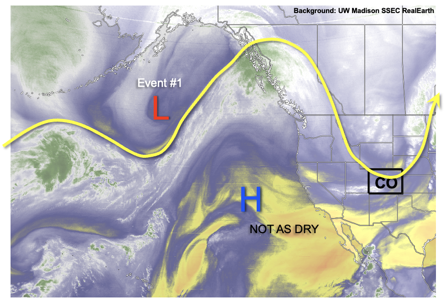
As shown in the water vapor image, below, a highly amplified jet stream is noted this morning across the central/eastern Pacific as well as North America. As described in this morning’s FTB, the current strong trough overhead will significantly cool off the entire state. However, this is a transient feature that will quickly move east and be replaced by a ridge. The primary end-product of this will be a return to much above normal temperatures. In fact, above normal temperatures, to the tune of 5-10F, are essentially expected through the rest of this Outlook as the aforementioned ridge moves eastward and parks itself over the central United States. At the same time, a strong trough will develop off the western North American coast resulting in southwesterly steering flow over Colorado. Interestingly, the eastern subtropical Pacific has moistened up a bit, after being very dry in the past 2 weeks or so. Thus, after a very dry week this week, moisture will return to Colorado, and likely stick around for awhile.
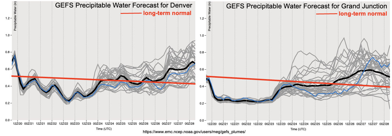
As shown in the Precipitable Water (PW) plumes, below, moisture will nosedive to below seasonal average statewide, but especially over the Western Slope. Coupled with increasingly higher temperatures this week, there could be a day or two with a wildfire threat. However, currently this looks to be mitigated by rather weak boundary layer winds. By later this week, moisture increases to near seasonal normal, and then above seasonal normal over the weekend. Although a return to precipitation is looking likely, the nature of the precipitation is highly uncertain given that heavy rainfall is becoming quite unlikely from a climatological perspective. Factors that could produce a low-end Elevated flood threat for a day or two would be the existence of a cut-off low that is being forecasted by some guidance. However, for now, the more likely outcome is light to moderate precipitation, with at least some weaker thunderstorms expected especially earlier in Event #1. Thus, there is No Apparent Flood Threat at this time, although this could change in the upcoming Outlooks.
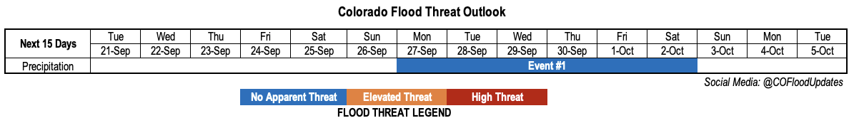
The identified precipitation event is described in more detail below.
Event #1: Monday – Saturday (September 27 – October 2)
Precipitation To Return, But No Apparent Flood Threat At This Time
Scattered precipitation could return by next weekend, but guidance is currently suggesting that the best chances will arrive by Monday, 9/27. At this time, it appears that the southwest quadrant of the state will see the best chances of precipitation exceeding 0.5 inches. However, with the likelihood of frontal passages, the entire state could see lighter precipitation up to 0.5 inches. The best chances of convective rainfall currently appear to be early in Event #1, from Monday through Wednesday when intensity exceeding 0.5 inches per hour could occur. Thereafter, cooler temperatures could reduce instability and favor more gentler precipitation rates, and higher elevation snowfall. Overall, given that heavy rainfall is quite unusual this late in the season, and with the absence of a clear dynamical feature, we are currently not expecting a flood threat with this event.