FTO 05-12-2022: Hot And Dry Early, Then Finally A Transition To A Wetter Pattern

Issue Date: Thursday, May 12th, 2022
Issue Time: 3PM MDT
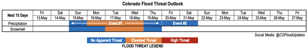
Valid Dates: 5/13-5/27

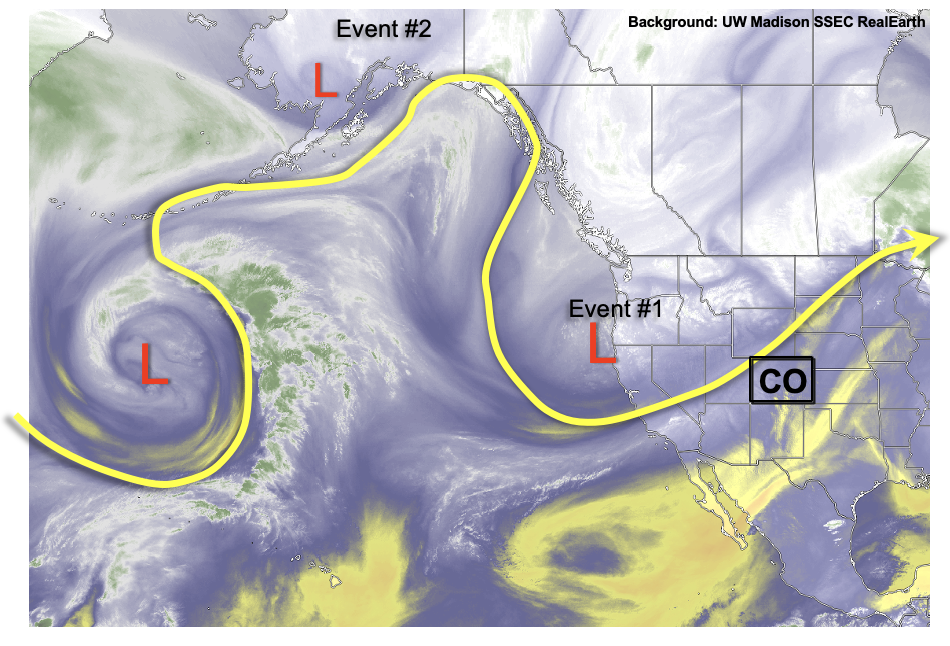
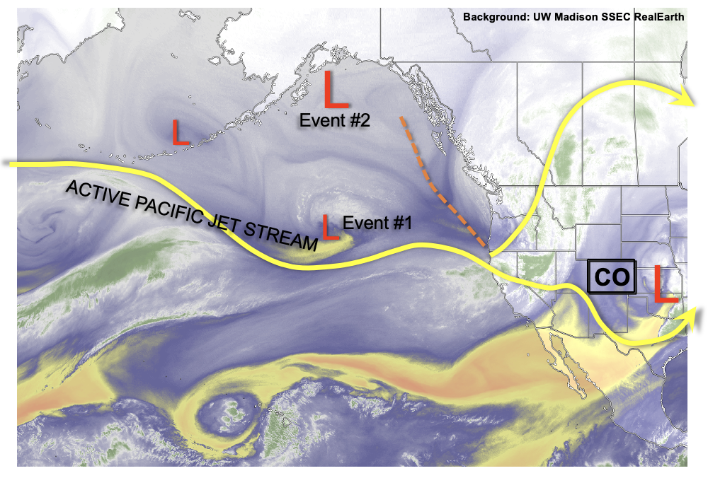
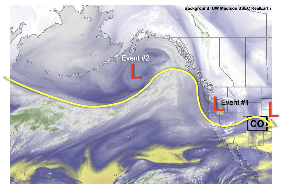
A look at this afternoon’s water vapor image across western North America and the eastern Pacific Ocean shows quite the soup of atmospheric ingredients. In fact, this active, high-amplitude pattern has been around for the better part of May. But for us in Colorado, it has been mainly a tease given that moisture levels have remained below normal. Instead, we have continued to see day after day of windy, mainly dry conditions supportive of Red Flag Warnings.

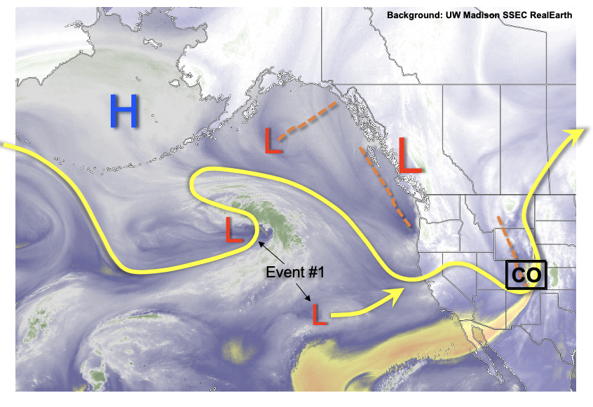
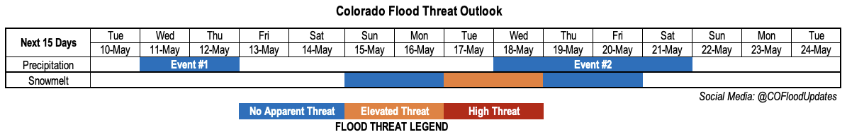
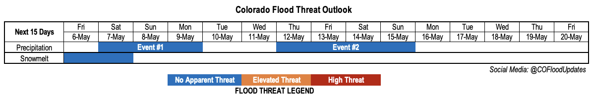
Fortunately, there are finally encouraging signs that precipitation will make a return to Colorado. That is the good news. The bad news is that we will still have to wait a bit longer – until early next week. Until then a temporary upper-level ridge will setup across the western United States that will provide seasonably warm weather through Saturday. By Sunday, the pair of disturbances noted over the eastern Pacific Ocean (Event #1) will quickly trek eastward, embedded within the larger upper-level trough expected to hang on over western Canada. Interestingly, note the southern disturbance contributing to Event #1 will be of subtropical origin.

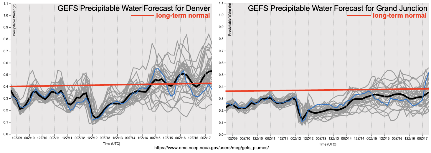
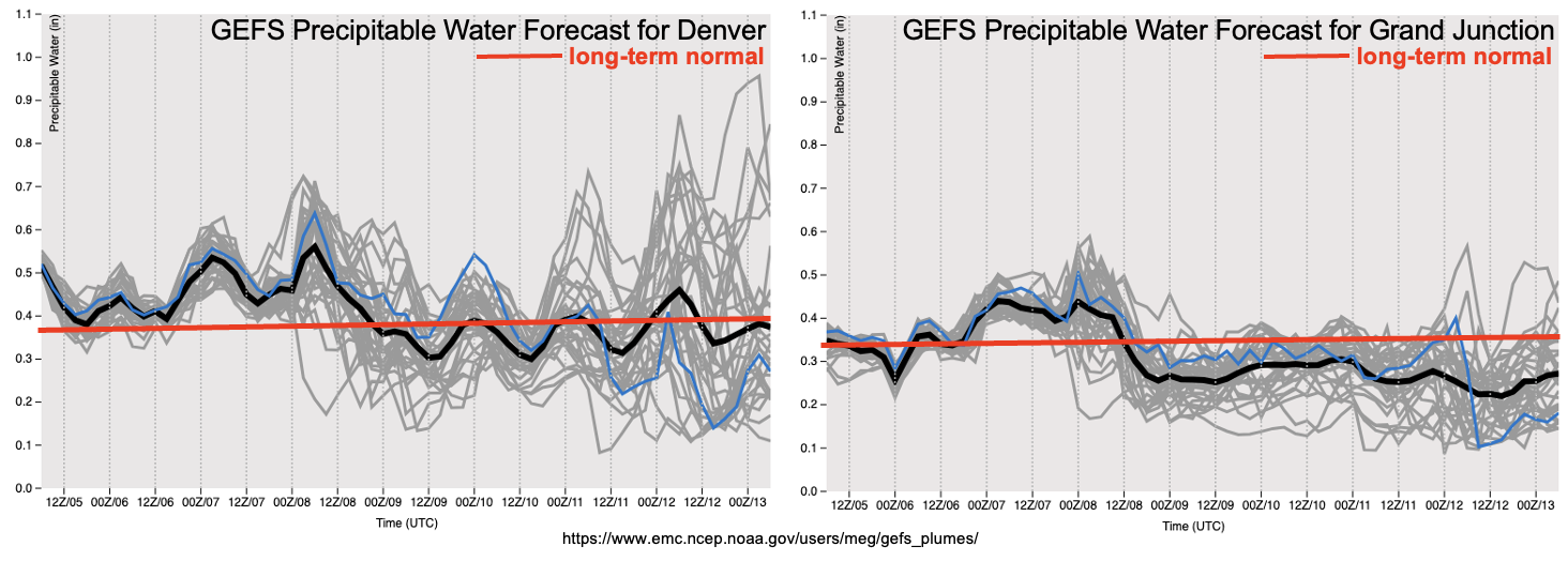
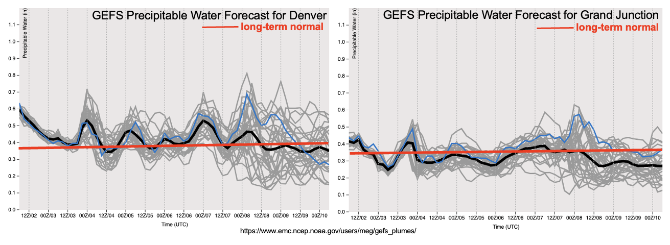
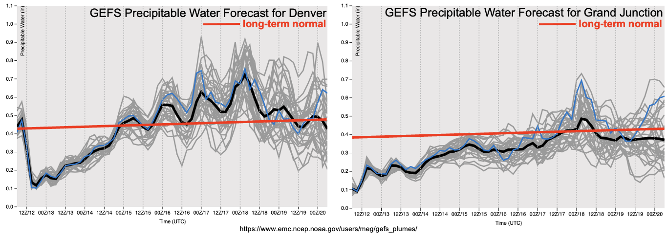
As can be seen with the forecasted PW plumes from the GEFS, the features comprising Event #1 will cause a notable spike in moisture with well above normal PW expected at Denver and even Grand Junction, though to a less degree. In addition dynamical support in the form of a shortwave will provide enough ingredients to warrant a 3-day Elevated flood threat mainly for the Northeast Plains. The primary threat, from the flooding perspective, will be for 1-3 hour flash flooding as afternoon and evening thunderstorms are expected to have plenty of moisture to work with. In addition, a severe weather threat will likely accompany these storms, in consistency with mid-May climatology.

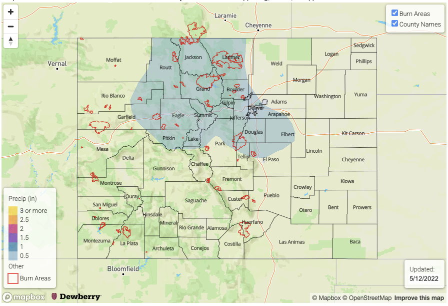
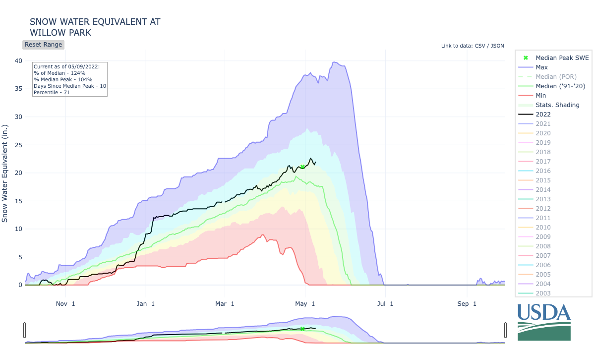
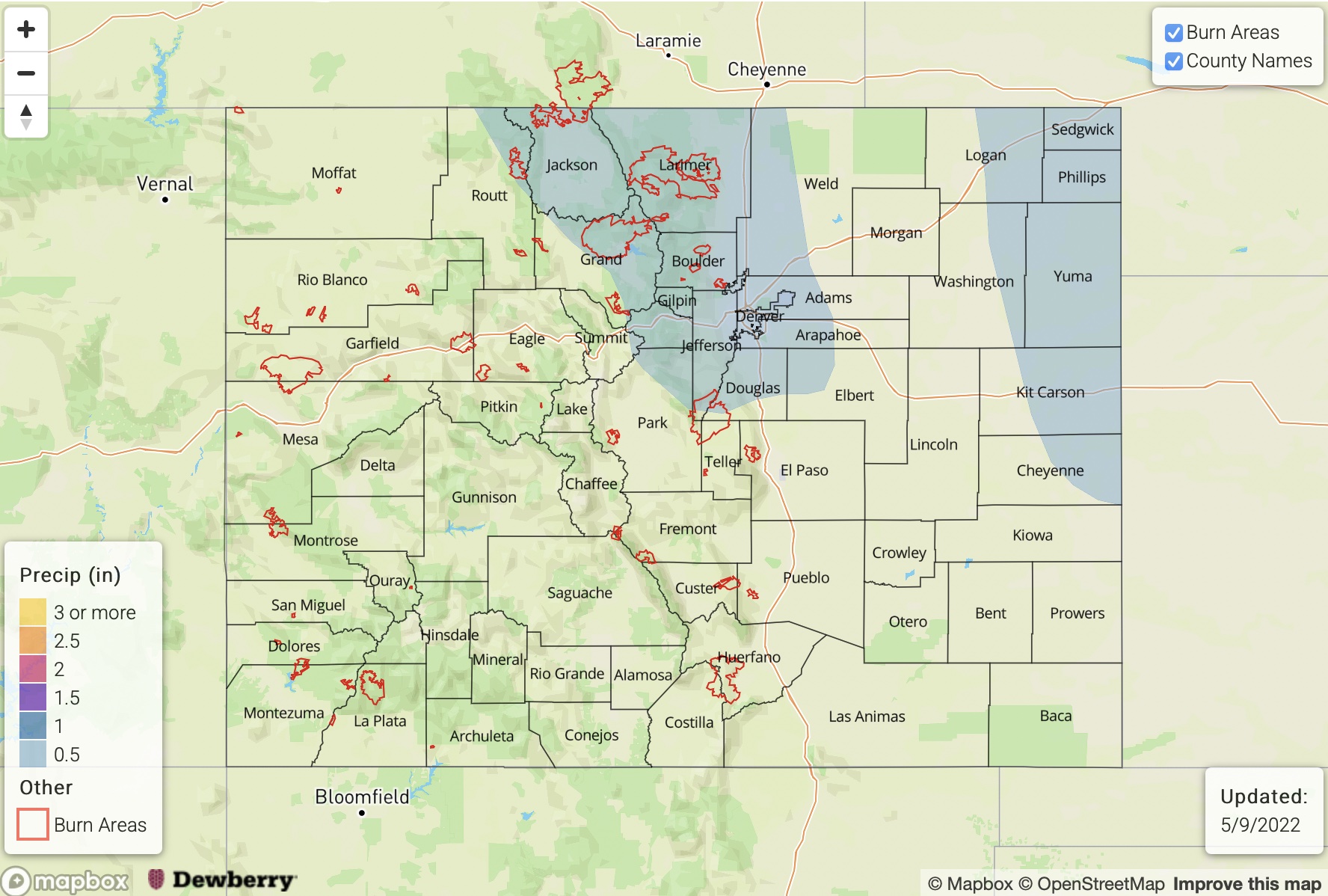
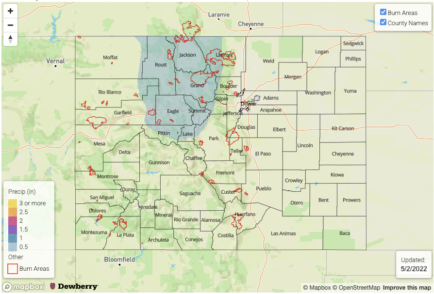
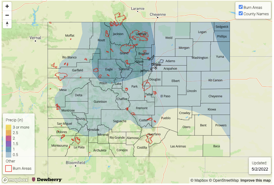
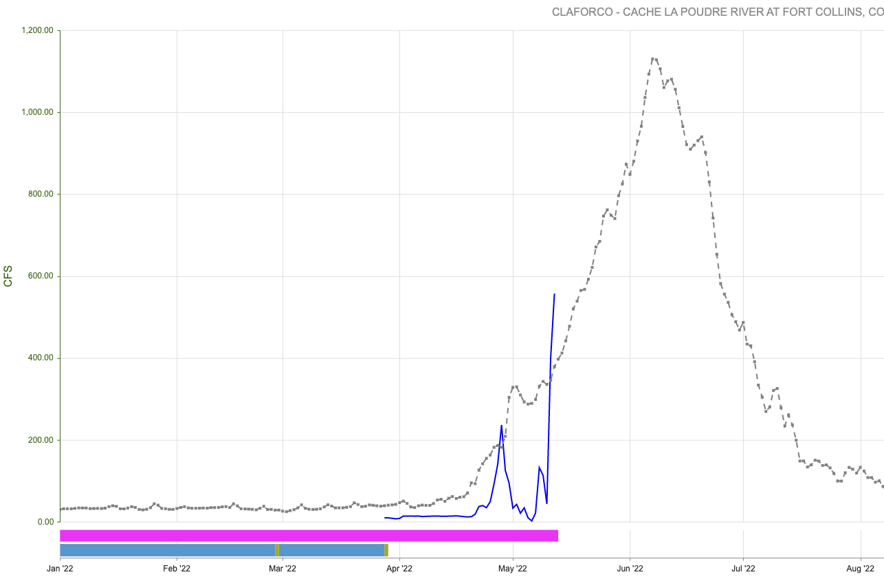
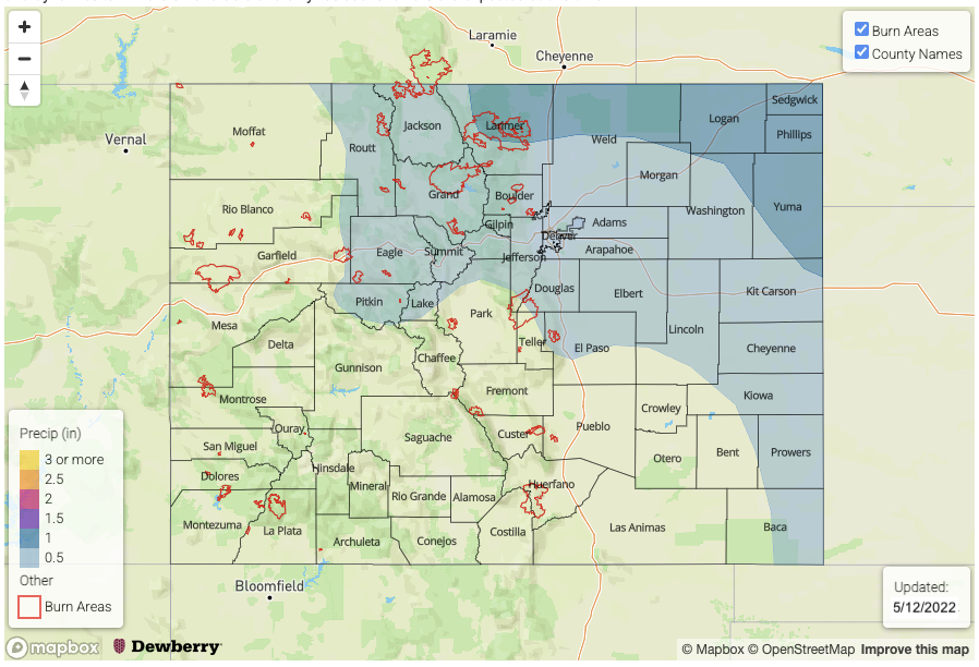
In concert with the increase in moisture will be a continuation of warm temperatures through the middle of next week. This will trigger the first major snowmelt for the Northern Mountains. With a large snowpack still in place across many ranges, we do expect some minor flooding concerns. The primary region of concern right now is the Cache La Poudre basin, which has begun its seasonal spike (see below). Also of concern are parts of the Elk Mountains, Medicine Bow and Laramie Mountains as well where smaller creeks and streams will probably see at least minor bank-side flooding. An Elevated flood threat has been highlighted for snowmelt next Monday through Wednesday.

Thereafter, current guidance suggests cooler temperatures and precipitation chances will persist through at least next weekend with another precipitation event coming in (Event #2). At this time, this event looks to provide mainly higher elevation rain and snow potential with flooding not anticipated. However, over the far eastern Plains, enough instability could creep back in from KS/OK to trigger a few storms. At this time, there is No Apparent Flood Threat.

The identified precipitation events are described in more detail below.

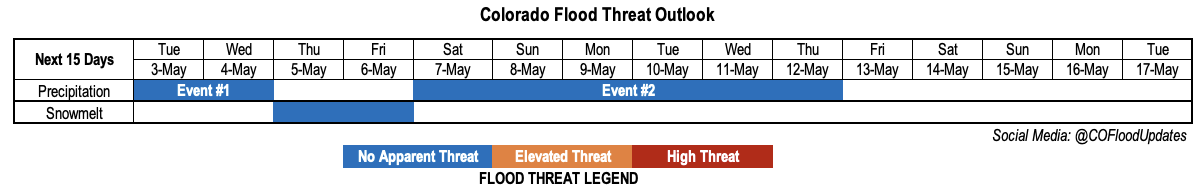
Event #1: Sunday – Thursday (May 15 – May 19)

Showers and Storms Expected Daily For The Eastern Plains; Elevated Flood Threat

Isolated showers and storms cannot be ruled out on Sunday, but limited moisture will prevent any major rainfall. By Monday and Tuesday, when the dynamics and moisture begin to affect the state in tandem, expect a round of afternoon and evening showers and storms both days over the Northeast Plains, but also possibly extending to the Southeast Plains, and westward to the Palmer Ridge and Urban Corridor. Max 1-hour rainfall up to 2.0 inches looks attainable, along with the threat of large hail. By Wednesday, activity is expected to move southeast into the Southeast Plains and be more isolated in nature, though enough moisture still warrants an Elevated threat. By Thursday, moisture decreases and dynamics turn more unfavorable and only residual showers are expected at this time.

Event #2: Friday – Saturday (May 20 – May 21)

Rain and Higher Elevation Snow Possible Over Northern Mountains; Rain Chances Over Plains Uncertain So No Apparent Flood Threat
There is more uncertainty with this event, but guidance is reasonably confident that a disturbance will provide widespread rain and snow over the higher terrain of the Front Range, Central Mountains and Northern Mountains. Precipitation amounts over 0.5 inches look possible with this event, though it will likely be too cold for a flood threat. Along the KS/OK border, it is possible that enough moisture will move back into the state to spark some showers and storms. But there are currently low odds of this happening, hence, no apparent flood threat.

FTO 05-09-2022: Spring Warmth To Take On Snowpack As Dry Conditions Prevail

Issue Date: Monday, May 9th, 2022
Issue Time: 3PM MDT
Valid Dates: 5/10-5/24

A look at the water vapor image over western North America and the eastern Pacific Ocean reveals plenty of “action”, with numerous large amplitude disturbances noted. In particular, a strong, large-scale trough has now established itself over western Canada and the Pacific Northwest. The trouble for Colorado, however, is that these features cannot quite make it far enough east to bring any meaningful dynamics and/or moisture into the state. As such, we are left with only light precipitation, but more notably dry and windy conditions. This will continue over the next week as another quick moving disturbance, Event #1, grazes by western and northern Colorado. Very limited precipitation, both rain and high-elevation snow, are possible over the Northern Mountains. Further east, some moisture return could spark an isolated thunderstorm right along the KS border on Wednesday. However, strong steering flow will push storms quickly into KS and limit precipitation on our side of the border. Over the course of now through the passage of Event #1, the state will be plagued by an elevated wildfire threat so expect more widespread Red Flag Warnings through Thursday. The wind finally looks to calm down thereafter.

As shown in the GEFS forecasted PW plumes, moisture will fortunately quickly return to the state after the passage of Event #1. Yet, with an expected ridge developing over the Great Basin by this weekend, there will not be any dynamics to make use of this moisture. Instead, above normal warmth will likely trigger a large pulse of snowmelt beginning on Sunday, and really amplifying by early next week as warm nighttime temperatures could keep a continuous melt going (as opposed to the typical freeze/thaw cycle). With this in mind, an Elevated flood threat looks possible by early next week for regions with a large remaining snowpack. This includes the Northern Mountains (see the Willow Park SWE trace below) and parts of the Central Mountains (notably, the Elk Mountain range). Only low-end flooding is expected at this time, with smaller creeks and streams running near or slightly above capacity.

Thereafter, signs point to moisture and dynamics returning to the state by later next week (Event #2). However, while there is some agreement regarding the moisture component, there is significant disagreement regarding the dynamics. The climatologically favored parts of the state, namely the Northeast Plains, look to be the most likely region for precipitation with Event #2.

The quiet early season conditions have given us a moment to take a step back and look at what may be driving our relatively dry and dusty spring. When it comes to large-scale atmospheric forcing, the El Nino-Southern Oscillation (ENSO) of the tropical Pacific usually dominates the news. And for a good reason: of all the climatic oscillations, it carries the strongest and longest lasting footprint on the atmosphere. As seen below, we are currently in a moderate to strong La Nina event. From a precipitation perspective, the ENSO impact on Colorado is rather difficult to generalize. This is because it (i) depends on the season, (ii) depends on the location and (iii) does not carry much, if any, statistical significance. What makes the situation more interesting, however, is this La Nina is occurring within a backdrop of a strongly negative Pacific Decadal Oscillation (PDO; note that La Nina partially forces a negative PDO so this is not entirely unexpected). The coincidence of these two does seem to amplify each individual forcing’s effect.

So what is this effect? Shown below are correlations between the NINO3.4 index (a measure of ENSO strength) and PW, from the NOAA ESRL regression and correlation website. Note that there is limited signal when using precipitation, hence the use of PW. This shows La Nina events tend to favor below normal PW conditions during April – June, which then favors drier than normal conditions (even if precipitation somehow ends up being normal). Of course, these correlations are not all that strong, so take this result with some uncertainty. The bit of other interesting news from this analysis is that by monsoon season, July-September, the correlations weaken substantially.

The identified precipitation events are described in more detail below.

Event #1: Wednesday – Thursday (May 11 – May 12)

Quick Moving Disturbance To Provide Light Rain/Snow North With Isolated Storms Far East, But No Apparent Flood Threat

Up to 0.25 inches of light rain and snow is possible in the Northern Mountains. Further east, up to 0.50 inches (very isolated) of rainfall is possible along the Kansas border as isolated storms cannot be ruled out.

Event #2: Wednesday – Thursday (May 18 – May 21)

Isolated Showers And Storms Possible As Moisture And Dynamics Return; No Apparent Flood Threat

Moisture and dynamics to return, but large uncertainty precludes the drawing of a precipitation map. Northeast Colorado looks to be the most favored region for precipitation at this time.

FTO 05-05-2022: A Shot Of Moisture Early, Then Warmth In The East With A Chill In The West; Precipitation Uncertain Until Late Next Week

Issue Date: Thursday, May 5th, 2022
Issue Time: 3PM MDT
Valid Dates: May 6 – May 20

The change in the longer-range precipitation forecast since Monday’s Outlook is one of the more extreme examples of forecast uncertainty. At that time, consensus across many models,  in consistency with spring climatology, suggested the likelihood of a large-scale trough developing over the western United States. This would promote dynamical support for upward motion across Colorado, as well as southerly moisture advection from the Gulf of Mexico and/or eastern subtropical Pacific. In short, precipitation chances looked quite promising.

Fast forward to today, the water vapor image, below, still shows a very active central Pacific jet. This tends to promote an “amplified” pattern on the eastern side of the jet stream, and there is still strong indication of a large-scale trough developing. The problem is the trough will likely be far enough west to have little affect on Colorado through the end of next week. Instead, after a fairly minor precipitation event over the weekend (Event #1), the state will enter a relatively dry stretch. The formation of the large-scale trough will be close enough to us to promote cooler temperatures west of the Continental Divide. However, to the east, especially in the Northeast and Southeast Plains, warm (perhaps hot?) weather is expected with little to no rainfall.

As shown in the forecast PW plumes from the GEFS, there is some indication of potential moisture being imported from the southern Great Plains by the end of next week. Note how this only shows up in the Denver sounding, a hint to the moisture’s origin. However, the model consensus is rather poor at this time and will depend largely on the ability of the large-scale trough to stay intact for a whole week (a long time in the forecasting world!). Thus, while we do anticipate a return to precipitation by late next week, there is No Apparent Flood threat at this time.

With temperatures running near seasonal normal over the higher terrain, snowmelt is expected to proceed at a slow-to-moderate pace. Friday and Saturday will see a pulse of melt especially over southern and central Colorado, but cooler temperatures thereafter should temper additional melt to its seasonal normal rate. A look at major river basins across the state shows the snowmelt has started in earnest for the Rio Grand, San Juan/Los Pinos/Animas and Dolores basins. However, the snowpack is still holding for the Gunnison, Upper Colorado and White/Yampa basins west of the Continental Divide. To the east, the North Platte, South Platte and Arkansas basins are still yet to see their spring pulse of water. In Monday’s Outlook, we will release our first statewide streamflow tracker to provide some actual flow numbers, so stay tuned!

The two identified precipitation events are described in more detail below.

Event #1: Saturday – Monday (May 7 – May 9)

Minor Rain and Snow Event for mainly the Northern Mountains; No Apparent Flood Threat

A small disturbance will bring a pulse of moisture for mainly northern Colorado resulting in a 36-48 hour period of rain and higher-elevation snow showers for the Northwest Slope, Northern Mountains and parts of the Front Range. Up to 0.5 inches of liquid equivalent is expected for the highest favored peaks, so a precipitation map is not provided.

Event #2: Thursday – Sunday (May 12 – May 15)

Precipitation Chances To Increase, But No Apparent Flood Threat Due To Uncertainty

The approach of the large-scale trough, in a strength yet to be determine, is still likely to promote a more active precipitation pattern for Colorado. At this time, it appears that moisture will be generally lacking. The most likely areas to experience precipitation above 0.5 inches are the climatologically favored Front Range and Urban Corridor as well as the Northeast Plains. In terms of heavy rainfall potential, it looks to be confined to the immediate KS border and eastward at this time. Precipitation above 1 inch is not expected with this event as of right now.

FTO 05-02-2022: Active Start To May With Several Rounds Of Widespread Precipitation Expected

Issue Date: Monday, May 2nd, 2022
Issue Time: 3PM MDT
Valid Dates: May 3 – May 17

After a windy, dusty and mainly dry April across most of our state, a welcome change towards wetter (and whiter!) conditions began today. Fortunately, this is not just a one-off event. Instead, as shown in the water vapor image, below, an active eastern Pacific storm track will deliver several disturbances into Colorado. The first disturbance, Event #1, will be a quick hitting passage that will produce widespread high-elevation snow, with more scattered and lighter precipitation east of the Continental Divide. The second event (Event #2) looks more interesting, yet more uncertain. A large-scale trough that is currently in the Gulf of Alaska, is expected to slowly move southeastward. Almost all guidance has it cutting off from the main flow, while maintaining its strength over the western United States. The uncertainty arises as to how far east it makes it before cutting off, and slowing down.

As shown in the GEFS ensemble PW plumes, below, Event #2 can be seen as the slight spike mainly in the Denver forecast on May 7 and May 8. Thereafter, uncertainty increases but there is loose consensus of synoptic scale support of precipitation, which is great news after our dry April.

The other bit of good news, at least from the water supply perspective, is generally below normal temperatures are expected over the next two weeks, especially over the higher terrain. However, in advance of Event #2, most of southern and central Colorado will experience a ~48 hour period of very warm afternoon temperatures (and a pulse of snow-melt mainly in the central and southern high terrains). Overall though, the snowpack is expected to hold firm into mid-May.

The identified precipitation events are described in more detail below.

Event #1: Tuesday-Wednesday (May 3 – May 4)

No Apparent Flood Threat As High Terrain To Experience Welcome Snowfall

A 24-48 hour period of snowfall is expected across mainly the higher terrain beginning Tuesday afternoon and continuing on through Wednesday. The higher parts of the Front Range, Northern Mountains and Central Mountains could see up to 1.0 inch of liquid equivalent, which is excellent news for the late season snowpack.

Further east, in lower elevations, the odds of precipitation are lower but at least scattered showers are expected over the Urban Corridor, Palmer Ridge and Northeast Plains. However, less than 0.5 inches of rainfall is expected at this time.

Event #2: Saturday – Thursday (May 7 – May 12)

Plenty Of Uncertainty But Prolonged Period Of Precipitation Possible; No Apparent Flood Threat At This Time

The development of the aforementioned large-scale, possibly cut-off trough somewhere over the Great Basin will put Colorado in a favorable position for prolonged on-and-off precipitation beginning late this weekend. At this time, it appears that widespread parts of the state, especially the northern half, should see over 0.5 inches of rain and higher elevation snowfall. The climatologically favored parts of the Northern Mountains and Front Range could see above 1.0 of liquid equivalent.

The heavy rainfall potential will likely be suppressed but may develop along the far east border with KS and OK as Gulf of Mexico moisture may get drawn into our state. At this time, this remains a rather small possibility and more detail will come with the next Outlook, on Thursday.