Issue Date: Monday, May 9th, 2022
Issue Time: 3PM MDT
Valid Dates: 5/10-5/24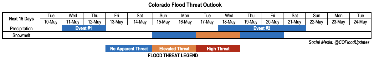
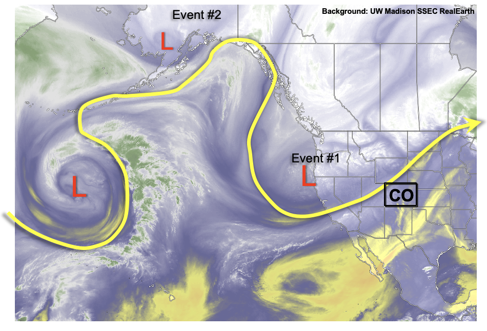
A look at the water vapor image over western North America and the eastern Pacific Ocean reveals plenty of “action”, with numerous large amplitude disturbances noted. In particular, a strong, large-scale trough has now established itself over western Canada and the Pacific Northwest. The trouble for Colorado, however, is that these features cannot quite make it far enough east to bring any meaningful dynamics and/or moisture into the state. As such, we are left with only light precipitation, but more notably dry and windy conditions. This will continue over the next week as another quick moving disturbance, Event #1, grazes by western and northern Colorado. Very limited precipitation, both rain and high-elevation snow, are possible over the Northern Mountains. Further east, some moisture return could spark an isolated thunderstorm right along the KS border on Wednesday. However, strong steering flow will push storms quickly into KS and limit precipitation on our side of the border. Over the course of now through the passage of Event #1, the state will be plagued by an elevated wildfire threat so expect more widespread Red Flag Warnings through Thursday. The wind finally looks to calm down thereafter.
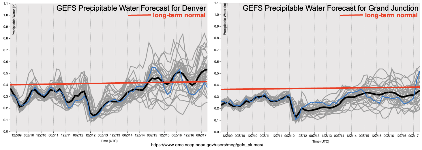
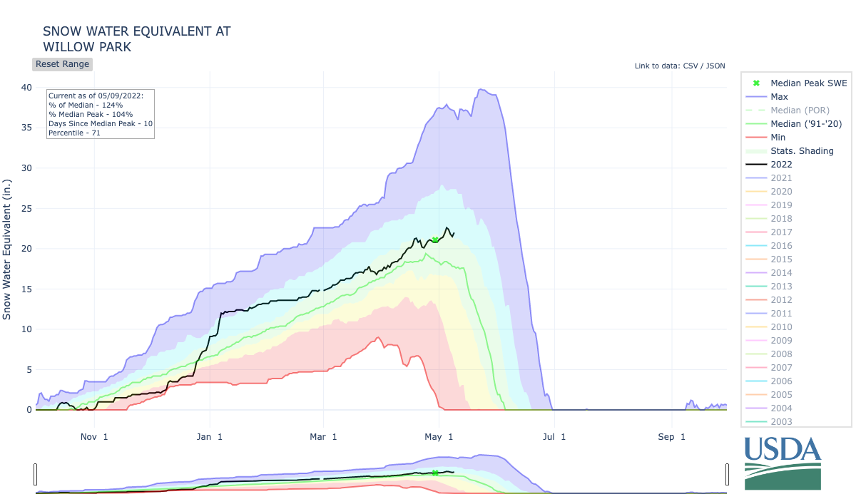
As shown in the GEFS forecasted PW plumes, moisture will fortunately quickly return to the state after the passage of Event #1. Yet, with an expected ridge developing over the Great Basin by this weekend, there will not be any dynamics to make use of this moisture. Instead, above normal warmth will likely trigger a large pulse of snowmelt beginning on Sunday, and really amplifying by early next week as warm nighttime temperatures could keep a continuous melt going (as opposed to the typical freeze/thaw cycle). With this in mind, an Elevated flood threat looks possible by early next week for regions with a large remaining snowpack. This includes the Northern Mountains (see the Willow Park SWE trace below) and parts of the Central Mountains (notably, the Elk Mountain range). Only low-end flooding is expected at this time, with smaller creeks and streams running near or slightly above capacity.
Thereafter, signs point to moisture and dynamics returning to the state by later next week (Event #2). However, while there is some agreement regarding the moisture component, there is significant disagreement regarding the dynamics. The climatologically favored parts of the state, namely the Northeast Plains, look to be the most likely region for precipitation with Event #2.
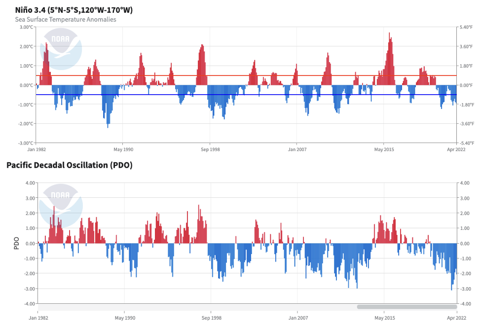
The quiet early season conditions have given us a moment to take a step back and look at what may be driving our relatively dry and dusty spring. When it comes to large-scale atmospheric forcing, the El Nino-Southern Oscillation (ENSO) of the tropical Pacific usually dominates the news. And for a good reason: of all the climatic oscillations, it carries the strongest and longest lasting footprint on the atmosphere. As seen below, we are currently in a moderate to strong La Nina event. From a precipitation perspective, the ENSO impact on Colorado is rather difficult to generalize. This is because it (i) depends on the season, (ii) depends on the location and (iii) does not carry much, if any, statistical significance. What makes the situation more interesting, however, is this La Nina is occurring within a backdrop of a strongly negative Pacific Decadal Oscillation (PDO; note that La Nina partially forces a negative PDO so this is not entirely unexpected). The coincidence of these two does seem to amplify each individual forcing’s effect.
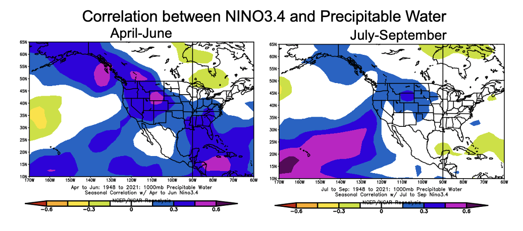
So what is this effect? Shown below are correlations between the NINO3.4 index (a measure of ENSO strength) and PW, from the NOAA ESRL regression and correlation website. Note that there is limited signal when using precipitation, hence the use of PW. This shows La Nina events tend to favor below normal PW conditions during April – June, which then favors drier than normal conditions (even if precipitation somehow ends up being normal). Of course, these correlations are not all that strong, so take this result with some uncertainty. The bit of other interesting news from this analysis is that by monsoon season, July-September, the correlations weaken substantially.
The identified precipitation events are described in more detail below.
Event #1: Wednesday – Thursday (May 11 – May 12)
Quick Moving Disturbance To Provide Light Rain/Snow North With Isolated Storms Far East, But No Apparent Flood Threat
Up to 0.25 inches of light rain and snow is possible in the Northern Mountains. Further east, up to 0.50 inches (very isolated) of rainfall is possible along the Kansas border as isolated storms cannot be ruled out.
Event #2: Wednesday – Thursday (May 18 – May 21)
Isolated Showers And Storms Possible As Moisture And Dynamics Return; No Apparent Flood Threat
Moisture and dynamics to return, but large uncertainty precludes the drawing of a precipitation map. Northeast Colorado looks to be the most favored region for precipitation at this time.