Issue Date: Thursday, May 5th, 2022
Issue Time: 3PM MDT
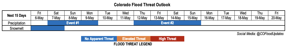
Valid Dates: May 6 – May 20
The change in the longer-range precipitation forecast since Monday’s Outlook is one of the more extreme examples of forecast uncertainty. At that time, consensus across many models, in consistency with spring climatology, suggested the likelihood of a large-scale trough developing over the western United States. This would promote dynamical support for upward motion across Colorado, as well as southerly moisture advection from the Gulf of Mexico and/or eastern subtropical Pacific. In short, precipitation chances looked quite promising.
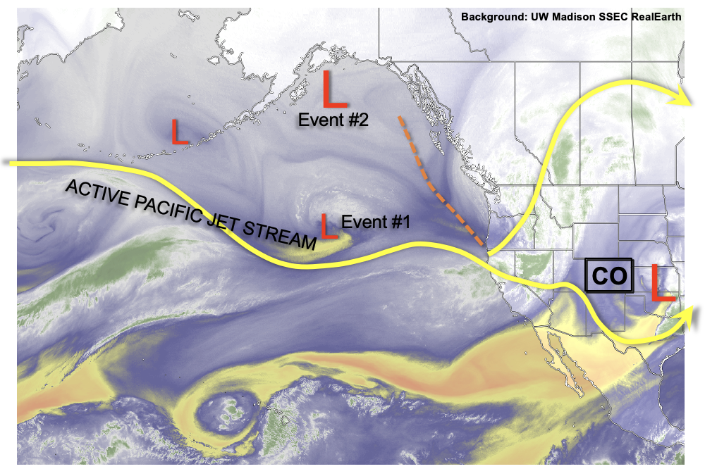
Fast forward to today, the water vapor image, below, still shows a very active central Pacific jet. This tends to promote an “amplified” pattern on the eastern side of the jet stream, and there is still strong indication of a large-scale trough developing. The problem is the trough will likely be far enough west to have little affect on Colorado through the end of next week. Instead, after a fairly minor precipitation event over the weekend (Event #1), the state will enter a relatively dry stretch. The formation of the large-scale trough will be close enough to us to promote cooler temperatures west of the Continental Divide. However, to the east, especially in the Northeast and Southeast Plains, warm (perhaps hot?) weather is expected with little to no rainfall.
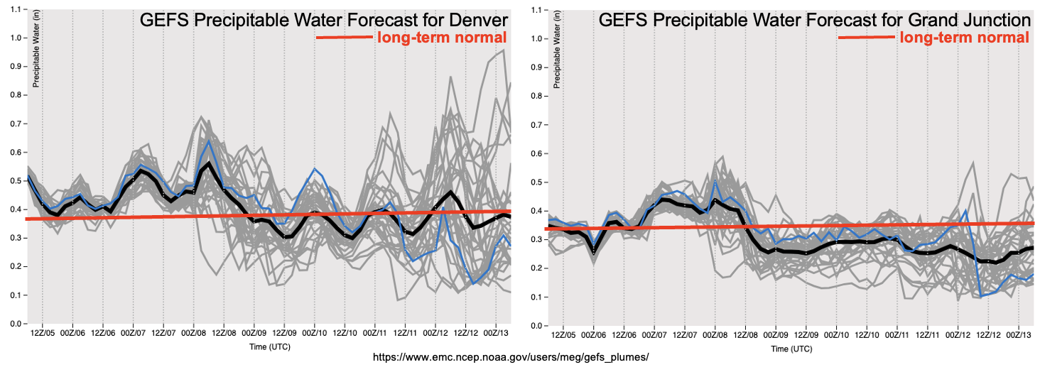
As shown in the forecast PW plumes from the GEFS, there is some indication of potential moisture being imported from the southern Great Plains by the end of next week. Note how this only shows up in the Denver sounding, a hint to the moisture’s origin. However, the model consensus is rather poor at this time and will depend largely on the ability of the large-scale trough to stay intact for a whole week (a long time in the forecasting world!). Thus, while we do anticipate a return to precipitation by late next week, there is No Apparent Flood threat at this time.
With temperatures running near seasonal normal over the higher terrain, snowmelt is expected to proceed at a slow-to-moderate pace. Friday and Saturday will see a pulse of melt especially over southern and central Colorado, but cooler temperatures thereafter should temper additional melt to its seasonal normal rate. A look at major river basins across the state shows the snowmelt has started in earnest for the Rio Grand, San Juan/Los Pinos/Animas and Dolores basins. However, the snowpack is still holding for the Gunnison, Upper Colorado and White/Yampa basins west of the Continental Divide. To the east, the North Platte, South Platte and Arkansas basins are still yet to see their spring pulse of water. In Monday’s Outlook, we will release our first statewide streamflow tracker to provide some actual flow numbers, so stay tuned!
The two identified precipitation events are described in more detail below.
Event #1: Saturday – Monday (May 7 – May 9)
Minor Rain and Snow Event for mainly the Northern Mountains; No Apparent Flood Threat
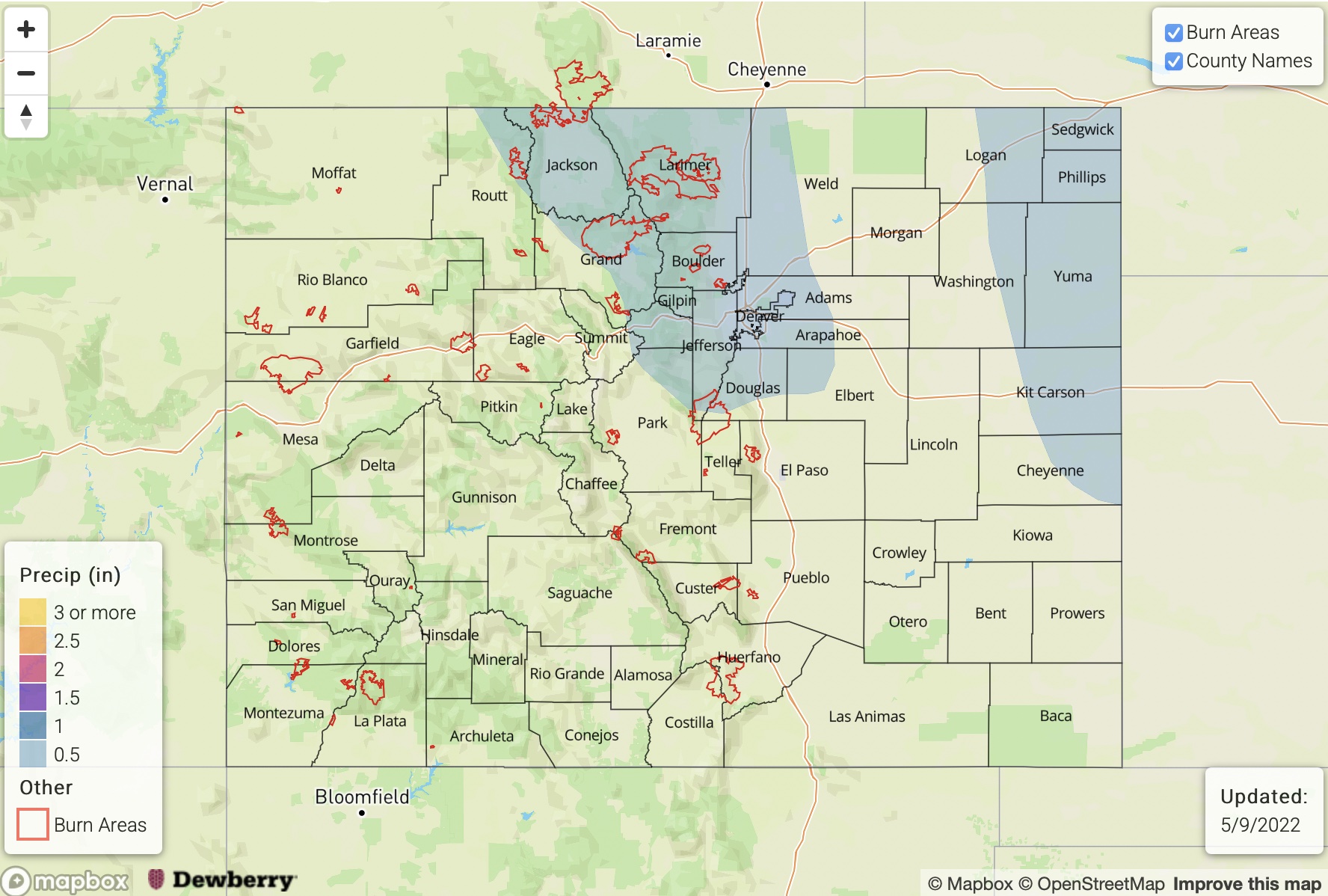
A small disturbance will bring a pulse of moisture for mainly northern Colorado resulting in a 36-48 hour period of rain and higher-elevation snow showers for the Northwest Slope, Northern Mountains and parts of the Front Range. Up to 0.5 inches of liquid equivalent is expected for the highest favored peaks, so a precipitation map is not provided.
Event #2: Thursday – Sunday (May 12 – May 15)
Precipitation Chances To Increase, But No Apparent Flood Threat Due To Uncertainty
The approach of the large-scale trough, in a strength yet to be determine, is still likely to promote a more active precipitation pattern for Colorado. At this time, it appears that moisture will be generally lacking. The most likely areas to experience precipitation above 0.5 inches are the climatologically favored Front Range and Urban Corridor as well as the Northeast Plains. In terms of heavy rainfall potential, it looks to be confined to the immediate KS border and eastward at this time. Precipitation above 1 inch is not expected with this event as of right now.