FTB 08-05-2020: Severe Storms Round 2 for the Plains

Issue Date: Wednesday, August 5th, 2020
Issue Time: 10:20AM MDT

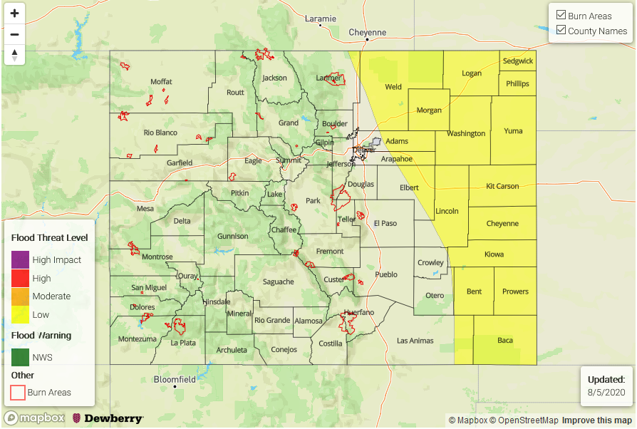
— A LOW flood threat has been issued for the Northeast Plains, Palmer Ridge, Southeast Plains, northern Urban Corridor, and northern/southeast portions of the Front Range

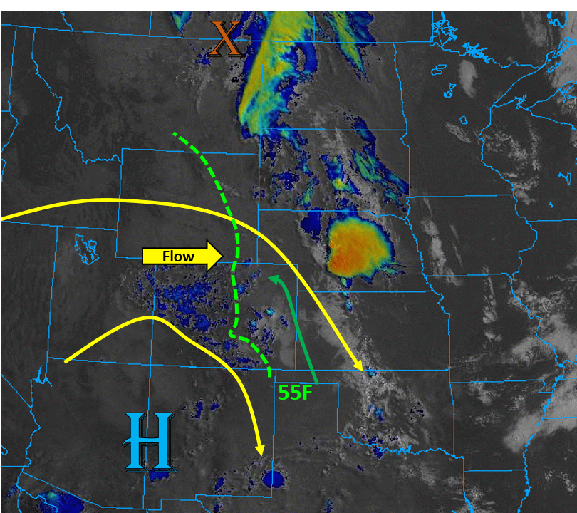
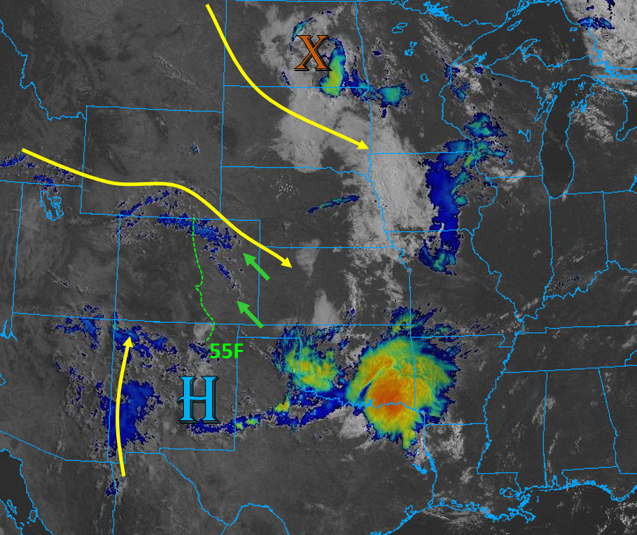
Today’s weather setup is very similar to yesterday’s as Colorado is situated between a high pressure ridge and a passing shortwave to the northeast (see satellite graphic below). This high pressure center has shifted slightly east today, which is bringing some mid-level moisture from the south over western New Mexico, as seen by the clouds (blue) in the satellite image below. This moisture will slowly push into the southwestern part of the state today and increase chances for clouds and some showers over the San Juan Mountains, but 30Fs surface dew points over the area this morning indicate rainfall will be light and isolated.

The bigger story today is the severe thunderstorms that are expected to track over the plains of eastern Colorado this afternoon. The height gradient between the high pressure ridge and the passing shortwave trough is creating some moderate mid-level flow over the north/northeast part of Colorado that is associated with an upper-level jet streak. This is causing some lift and generating clouds and showers (blue on the image below) over the northern and northeast part of the state this morning. This upper-level flow will continue over the northeastern part of the state today, which will increase wind shear and favor more organized thunderstorms. This stronger upper-level flow will also push storms off to the east quicker, but heavy rainfall is still expected under the stronger storm cores.

As the sun heats up the surface today, low pressure axis will develop over the high terrain and create upslope east-southeasterly surface winds for much of the plains. Surface dew points will remain in the mid to upper 50Fs for most of the lower, eastern elevations with higher 60Fs forecast for the far eastern plains as the moisture will continue to be banked up against the eastern mountains (see graphic below). This will help increase instability over the area this afternoon, and set the stage for heavy rainfall. However, due to slower upper-level flow farther south (less favorable upper-level dynamics), storms that can potentially break the cap over the Southeast Plains should be more isolated in nature, but still capable of producing high rainfall rates. So, the Low flood threat has been extended south.

The highest chances for storms will be over the Northeast Plains and Palmer Ridge today. Max rain rates up to 1.6 in/hr are possible with the storms, so a Low flood threat has been issued. Strong winds up to 65 mph are possible with the severe storms, especially over the Northeast Plains, and as storms develop further west, another round of severe hail up to (2 inch in diameter) is also possible.

Today’s Flood Threat Map

For more information on today’s flood threat, see the map below. Hover over the threat areas for more details, and click on burn areas to learn more about them. For Zone-Specific forecasts, scroll below the threat map.

Zone-Specific Forecasts:

Northeast Plains, Southeast Plains, Palmer Ridge, Raton Ridge, Urban Corridor, Front Range, & Southeast Mountains:

Storms will fire around noon over the northern Front Range, Palmer Ridge, and Urban Corridor, and as they make their way east, they could become severe. There is also an increased chance for a squall line over the Northeast Plains, so strong, damaging winds will be possible. Back west, severe hail (up to 2 inches) will be possible. Max rain rates with storms over the plains this afternoon are 1.6 inches per hour, so a Low flood threat has been issued for the Northeast Plains, northern Urban Corridor, northern Front Range, Palmer Ridge, and portions of the Southeast Plains. Rain rates up to 1 in/hr are more likely further west along the Front Range.

A lower chance of storms is expected further south over the Southeast Plains, but a few isolated strong storms could fire over the western part of the area if they can break through the cap with help from other storms’ outflow boundaries. Max 1-hour rain rates up to 1.6 inches will be possible. With the nocturnal low-level jet along the southeastern border of Colorado, showers and storms may linger over the Southeast Plains into the overnight hours. These storms should be weaker due to limited instability, so flooding is not expected overnight.

Primetime: 12PM to midnight

Grand Valley, Northwest Slope, Northern Mountains, Central Mountains, Southwest Slope, San Luis Valley, & San Juan Mountains:

Mainly sunny for most of the region, but some afternoon clouds and weak showers are possible over the high terrain ridgelines. Best chance for rainfall will be over the San Juan Mountains where rain rates up to 0.1 inches per hour will be possible. Since most of the moisture will be in the mid-levels, the better bet is more cloud cover than wetting rainfall.

Primetime: 12PM to 7PM

FTB 08-04-2020: Severe Weather and Heavy Rainfall Threat for Plains

Issue Date: Tuesday, August 4th, 2020
Issue Time: 10:25AM MDT

— A LOW flood threat has been issued for the Northeast Plains, Southeast Plains, Palmer Ridge, and northern Urban Corridor

Today there exists a severe thunderstorm threat over the plains of eastern Colorado as a weak shortwave passes north of Colorado, squashing the high pressure ridge to the southwest of Colorado. This setup is shown in the graphic below, which is causing more zonal mid-level flow. This flow is stronger over northern Colorado and is creating some lift already this morning, indicated by the scattered mid-level clouds (blue) on the satellite image below. Upper-level energy will continue to move through the west-northwest flow today, which will increase wind shear and lift over the plains of eastern Colorado.

Moisture is banked up against the Rocky Mountains from Colorado up into Montana, with dew points in the mid 50Fs across much of eastern Colorado this morning. A surface low is expected to develop on the Palmer Divide this afternoon, which will allow this moisture to continue to be pumped into the eastern plains with enhanced southeasterly/easterly surface flow (green arrow). This feature will also scour out moisture further south with more westerly surface winds, limiting rainfall chances over the Southeast Mountains. Storms will initiate over the Front Range and Cheyenne Ridge and track southeast (south) and east (north) earlier this afternoon. Due to 55F+ surface dew points, moderate wind shear, and plenty of diurnal surface heating over eastern Colorado, upscale growth of storms is expected as the storms move into the plains with a possible MCS forming into the evening hours as the low level jet kicks in. As these storms move into the higher surface moisture in the plains, convective cells could become quite strong and produce max rain rates up to 1.7 in/hr, so a Low flood threat has been issued. Additionally, since we have seen some stronger storms develop over Larimer and Weld counties the last several days, the Low flood threat has been pulled northwest into the far northern Urban Corridor.

Today’s Flood Threat Map

For more information on today’s flood threat, see the map below. Hover over the threat areas for more details, and click on burn areas to learn more about them. For Zone-Specific forecasts, scroll below the threat map.

Zone-Specific Forecasts:

Front Range, Urban Corridor, Northeast Plains, Palmer Ridge, Southeast Plains, & Raton Ridge:

Plenty of low-level moisture (50F to 60F) combined with strong diurnal heating will allow thunderstorms to fire this afternoon, which will work their way east/southeast. Strong wind shear will allow these storms to organize into upscale systems as they move east/southeast over the plains. Initially the severe storms that develop will be capable of producing large hail up to 2 inches in diameter. As upscale growth occurs further over the eastern plains, the main threat will be damaging wind gusts up to 70 mph. Max rain rates up to 1.7 in/hr are expected with the strongest cells, which could cause flooding of roads, low-lying areas, and arroyos. A Low flood threat has been issued.

Primetime: 1PM to 12AM

Grand Valley, Northwest Slope, Northern Mountains, Central Mountains, Southwest Slope, San Juan Mountains, San Luis Valley, & Southeast Mountains:

It has really started to dry out with the more westerly component to the upper-level flow. It will be sunny and warm today with isolated, weak rainfall developing over the high terrains and quickly moving east. The highest chances for precipitation is over the Northern Mountains, but storm totals should stay below 0.10 inches. Some brief winds (up to 35 mph) are possible as the storms dissipate when they move off the high terrains, so no flooding is expected.

FTB 08-03-2020: Similar Set Up to Sunday Returns the Flood Threat

Issue Date: Monday, August 3rd, 2020
Issue Time: 9:45AM MDT 

— A LOW flood threat has been issued for the Palmer Ridge, Raton Ridge, southern Urban Corridor, and portions of the Southeast Mountains, Southeast Plains, and Front Range. This includes the Spring Creek burn area.

The leftover convection from the feature causing the early morning, heavy rainfall over the Northeast Plains can be seen in the visible satellite imagery below over Kansas (orange “X”). There is also a bit of fog and stratus to start the day, which should begin to burn off with a little daytime heating. Today, the ridge will begin to break down/be pushed south as a strong Low moves into the Gulf of Alaska and forces the shortwave over the Pacific Northwest to the E/NE. This will pull some mid-level energy into the state, which is marked with an orange “X” over Utah as flow becomes slightly more westerly. PW at Grand Junction was measured at 0.69 inches with most moisture in the mid-levels, and a decreasing trend in PW will mean another day of high-based convection producing more wind than rainfall. Weak storms and rainfall will favor the same areas as yesterday (San Juans and areas near/along the Continental Divide north) with the heaviest rain rates again over the eastern/southern San Juan Mountains.

Over the eastern high terrains, more storm coverage is anticipated with activity spilling into the adjacent plains later this afternoon and evening with the NW/WNW steering flow continuing. As storms move off the mountains, convection will most likely survive only over the elevated regions of the Cheyenne, Palmer and Raton Ridges. The severe thunderstorm threat is lower than yesterday, but some severe hail and strong outflow winds will still be possible with a couple of the stronger storms. With storm speeds similar to yesterday (fast), the flood threat from an individual thunderstorm is not high. However, with southeast and easterly surface winds keeping low-level moisture intact, 1-hour rainfall rates up to 1.2 inches over the plains will be possible, so a Low flood threat has been issued for this reason. If multiple storms track over the Spring Creek burn area, totals up to 0.6 inches will be possible, so the Low flood threat has been pulled back to the west.

Today’s Flood Threat Map

For more information on today’s flood threat, see the map below. If there is a threat, hover over the threat areas for more details, and click on burn areas to learn more about them. For Zone-Specific forecasts, scroll below the threat map.

Zone-Specific Forecasts:

Urban Corridor, Front Range, Northeast Plains, Palmer Ridge, Southeast Plains, Southeast Mountains, & Raton Ridge:

Expecting more of a westerly component to the steering flow this afternoon, so storms will again spill into the adjacent plains and into higher surface moisture. The best chance for survival will be over the elevated ridges that can provide a little more surface convergence. Max 1-hour rain rates up to 1.2 inches will be possible, so a Low flood threat has been issued. If more than one storm tracks over the Spring Creek burn area, totals up to 0.6 inches will be possible, so a Low flood threat has been issued. Over the Front Range, max 1-hour rain rates up to 0.5 inches (south) and 0.25 inches (north) will be possible with isolated totals up to 0.5 inches possible over the northern Urban Corridor. Storms should decrease in intensity just after sundown, but light showers may linger until about midnight.

Primetime: 1PM to Midnight

San Juan Mountains, Central Mountains, Northern Mountains, Southwest Slope, Northwest Slope, Grand Valley, & San Luis Valley:

Very similar to yesterday, but with a slight decrease in coverage. Isolated storms are anticipated over the western San Juan Mountains and over the Central Mountains near the Divide as drier air works in. With larger dew point depressions, storms could produce some strong outflow winds. Max 1-hour rain rates up to 0.15 inches will be possible. Higher rain rates are anticipated over the eastern/southern San Juan Mountains (up to 0.5 inches) and small hail could also be possible with stronger storms that form. Flooding is not forecast.

Primetime: 1PM to 8PM

FTB 08-02-2020: Flood Threat Increases along with the Severe Thunderstorm Threat

Issue Date: Sunday, August 2nd, 2020
Issue Time: 9:30AM MDT

— A MODERATE flood threat has been issued for Palmer Ridge, portions of the Southeast Plains, and the Spring Creek burn area

— A LOW flood threat has been issued for the Southeast Mountains, southern Front Range, southern Urban Corridor, Raton Ridge, and Decker burn area

Moderate rainfall and some thunder to start the morning over the SE Plains border counties. Behind the front that passed through yesterday, there’s quite a bit of moisture with dew points (more or less) greater than 50F present to the east of the green dashed line below. PW values have jumped back up to 0.75 inches in the Denver sounding, and easterly/southeasterly surface winds this afternoon and evening over the plains should help reinforce the low-level moisture over eastern Colorado.

With the large-scale trough moving onshore (Pacific Northwest), the ridge axis will be displaced to the east and help bring in some more mid-level energy into the state. Also, more shear is available this afternoon. Therefore, some stronger thunderstorms are expected over the eastern mountains with northwesterly flow helping spill them into the adjacent plains where they may become severe. Training storms will return the flood threat and the severe storms that develop, over the adjacent plains, will also be capable of producing large hail and strong outflow winds. Even though storm motion is expected to be 20-25 mph, there is increased likelihood storms will be able to produce a quick 0.50 inches over the Southeast Mountains near the Spring Creek burn area. A Moderate threat has been issued for this burn scar as well as over the Palmer Ridge. A Low flood threat has been issued for the adjacent plains and Southeast Mountains. Back to the west over the San Juan Mountains, rain rates should be low enough that they aren’t expected to cause flooding issues.

Today’s Flood Threat Map

For more information on today’s flood threat, see the map below. If there is a threat, hover over the threat areas for more details, and click on burn areas to learn more about them. For Zone-Specific forecasts, scroll below the threat map.

Zone-Specific Forecasts:

Southeast Mountains, Palmer Ridge, Raton Ridge, Southeast Plains, Front Range, Urban Corridor, & Northeast Plains: 

Stronger storms are forecast with a severe thunderstorm threat over the Palmer Ridge, Southeast Plains, and Raton Ridge. Max 1-hour rain rates up to 1.5 inches will be possible with these stronger storms along with large hail and damaging outflow winds (up to 60 mph). Stay tuned into your local NWS office later today for the latest as a Moderate/Low flood threat has been issued. Over the mountains, storm totals up to 0.75 inches will be possible with higher rain rates over the southern Southeast Mountains when compared to the last couple of days. Thus, a Moderate flood threat has been issued for the Spring Creek burn area, but a Low flood threat should suffice for the Decker burn area as the set up isn’t quite as favorable for storm development over the area. Over the northern Front Range and Urban Corridor, more isolated storms are forecast with totals up to 0.6 inches possible.

Primetime: 1PM to 1AM

San Juan Mountains, Central Mountains, San Luis Valley, Northern Mountains, Southwest Slope, Northwest Slope, & Grand Valley:

More widespread storm activity is expected over the southern/eastern San Juan Mountains with more isolated storms over the western San Juan Mountains. Higher rain rates are expected east (0.6 inches) with more wind anticipated west and to the north over the Central Mountains. Isolated storm totals up to 0.25 inches (south) will still be possible, but further north, more cloud cover and sprinkles are forecast. Steering flow could push some of this rain into the western San Luis Valley with totals up to 0.15 inches possible by morning. Flooding is not forecast. It’s also quite hot over Grand Valley already (orange circle in the surface map), so hitting the century mark again is forecast.

Primetime: 1PM to 8PM