Issue Date: Monday, August 3rd, 2020
Issue Time: 9:45AM MDT
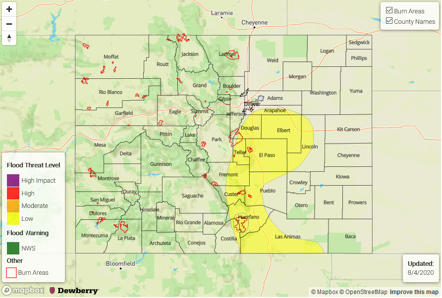
— A LOW flood threat has been issued for the Palmer Ridge, Raton Ridge, southern Urban Corridor, and portions of the Southeast Mountains, Southeast Plains, and Front Range. This includes the Spring Creek burn area.
The leftover convection from the feature causing the early morning, heavy rainfall over the Northeast Plains can be seen in the visible satellite imagery below over Kansas (orange “X”). There is also a bit of fog and stratus to start the day, which should begin to burn off with a little daytime heating. Today, the ridge will begin to break down/be pushed south as a strong Low moves into the Gulf of Alaska and forces the shortwave over the Pacific Northwest to the E/NE. This will pull some mid-level energy into the state, which is marked with an orange “X” over Utah as flow becomes slightly more westerly. PW at Grand Junction was measured at 0.69 inches with most moisture in the mid-levels, and a decreasing trend in PW will mean another day of high-based convection producing more wind than rainfall. Weak storms and rainfall will favor the same areas as yesterday (San Juans and areas near/along the Continental Divide north) with the heaviest rain rates again over the eastern/southern San Juan Mountains.
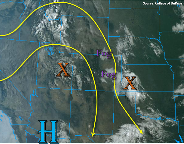
Over the eastern high terrains, more storm coverage is anticipated with activity spilling into the adjacent plains later this afternoon and evening with the NW/WNW steering flow continuing. As storms move off the mountains, convection will most likely survive only over the elevated regions of the Cheyenne, Palmer and Raton Ridges. The severe thunderstorm threat is lower than yesterday, but some severe hail and strong outflow winds will still be possible with a couple of the stronger storms. With storm speeds similar to yesterday (fast), the flood threat from an individual thunderstorm is not high. However, with southeast and easterly surface winds keeping low-level moisture intact, 1-hour rainfall rates up to 1.2 inches over the plains will be possible, so a Low flood threat has been issued for this reason. If multiple storms track over the Spring Creek burn area, totals up to 0.6 inches will be possible, so the Low flood threat has been pulled back to the west.
Today’s Flood Threat Map
For more information on today’s flood threat, see the map below. If there is a threat, hover over the threat areas for more details, and click on burn areas to learn more about them. For Zone-Specific forecasts, scroll below the threat map.
Zone-Specific Forecasts:
Urban Corridor, Front Range, Northeast Plains, Palmer Ridge, Southeast Plains, Southeast Mountains, & Raton Ridge:
Expecting more of a westerly component to the steering flow this afternoon, so storms will again spill into the adjacent plains and into higher surface moisture. The best chance for survival will be over the elevated ridges that can provide a little more surface convergence. Max 1-hour rain rates up to 1.2 inches will be possible, so a Low flood threat has been issued. If more than one storm tracks over the Spring Creek burn area, totals up to 0.6 inches will be possible, so a Low flood threat has been issued. Over the Front Range, max 1-hour rain rates up to 0.5 inches (south) and 0.25 inches (north) will be possible with isolated totals up to 0.5 inches possible over the northern Urban Corridor. Storms should decrease in intensity just after sundown, but light showers may linger until about midnight.
Primetime: 1PM to Midnight
San Juan Mountains, Central Mountains, Northern Mountains, Southwest Slope, Northwest Slope, Grand Valley, & San Luis Valley:
Very similar to yesterday, but with a slight decrease in coverage. Isolated storms are anticipated over the western San Juan Mountains and over the Central Mountains near the Divide as drier air works in. With larger dew point depressions, storms could produce some strong outflow winds. Max 1-hour rain rates up to 0.15 inches will be possible. Higher rain rates are anticipated over the eastern/southern San Juan Mountains (up to 0.5 inches) and small hail could also be possible with stronger storms that form. Flooding is not forecast.
Primetime: 1PM to 8PM