Issue Date: Tuesday, August 4th, 2020
Issue Time: 10:25AM MDT
— A LOW flood threat has been issued for the Northeast Plains, Southeast Plains, Palmer Ridge, and northern Urban Corridor
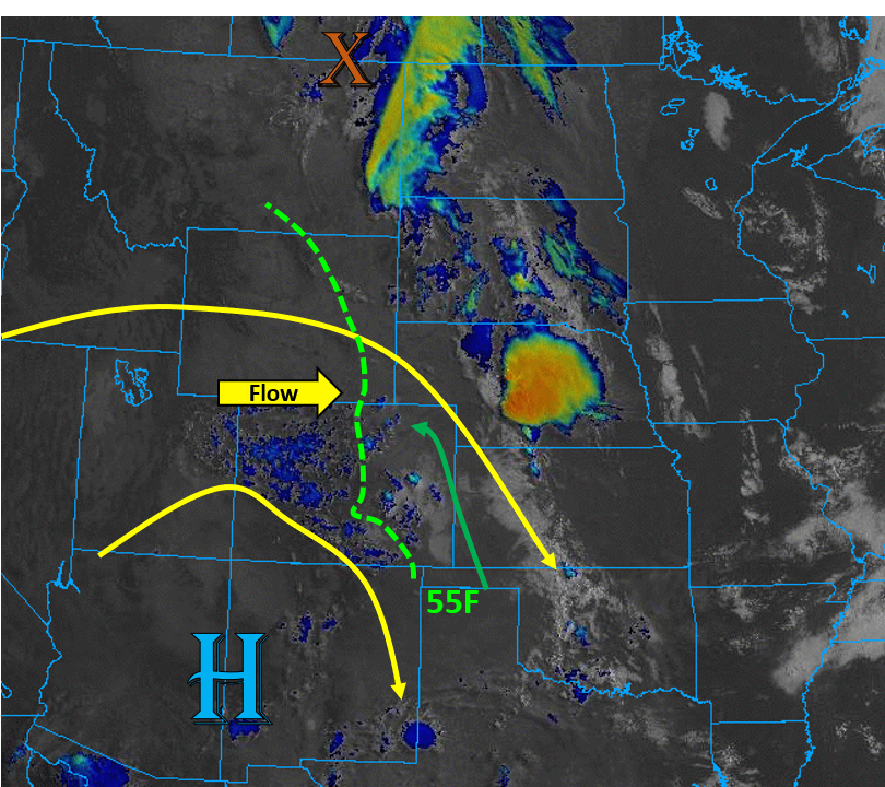
Today there exists a severe thunderstorm threat over the plains of eastern Colorado as a weak shortwave passes north of Colorado, squashing the high pressure ridge to the southwest of Colorado. This setup is shown in the graphic below, which is causing more zonal mid-level flow. This flow is stronger over northern Colorado and is creating some lift already this morning, indicated by the scattered mid-level clouds (blue) on the satellite image below. Upper-level energy will continue to move through the west-northwest flow today, which will increase wind shear and lift over the plains of eastern Colorado.
Moisture is banked up against the Rocky Mountains from Colorado up into Montana, with dew points in the mid 50Fs across much of eastern Colorado this morning. A surface low is expected to develop on the Palmer Divide this afternoon, which will allow this moisture to continue to be pumped into the eastern plains with enhanced southeasterly/easterly surface flow (green arrow). This feature will also scour out moisture further south with more westerly surface winds, limiting rainfall chances over the Southeast Mountains. Storms will initiate over the Front Range and Cheyenne Ridge and track southeast (south) and east (north) earlier this afternoon. Due to 55F+ surface dew points, moderate wind shear, and plenty of diurnal surface heating over eastern Colorado, upscale growth of storms is expected as the storms move into the plains with a possible MCS forming into the evening hours as the low level jet kicks in. As these storms move into the higher surface moisture in the plains, convective cells could become quite strong and produce max rain rates up to 1.7 in/hr, so a Low flood threat has been issued. Additionally, since we have seen some stronger storms develop over Larimer and Weld counties the last several days, the Low flood threat has been pulled northwest into the far northern Urban Corridor.
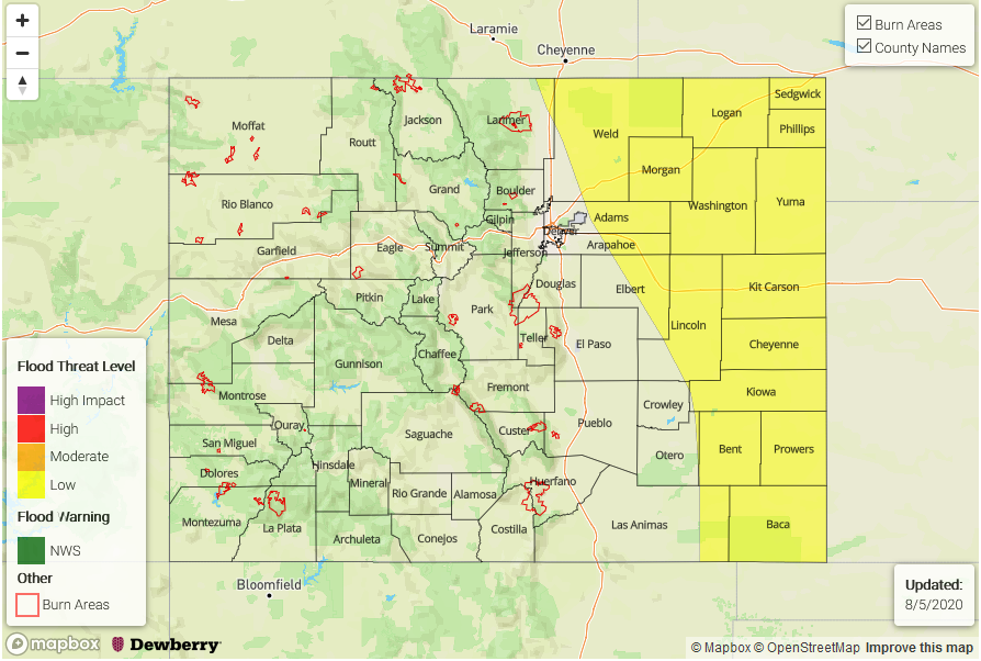
Today’s Flood Threat Map
For more information on today’s flood threat, see the map below. Hover over the threat areas for more details, and click on burn areas to learn more about them. For Zone-Specific forecasts, scroll below the threat map.
Zone-Specific Forecasts:
Front Range, Urban Corridor, Northeast Plains, Palmer Ridge, Southeast Plains, & Raton Ridge:
Plenty of low-level moisture (50F to 60F) combined with strong diurnal heating will allow thunderstorms to fire this afternoon, which will work their way east/southeast. Strong wind shear will allow these storms to organize into upscale systems as they move east/southeast over the plains. Initially the severe storms that develop will be capable of producing large hail up to 2 inches in diameter. As upscale growth occurs further over the eastern plains, the main threat will be damaging wind gusts up to 70 mph. Max rain rates up to 1.7 in/hr are expected with the strongest cells, which could cause flooding of roads, low-lying areas, and arroyos. A Low flood threat has been issued.
Primetime: 1PM to 12AM
Grand Valley, Northwest Slope, Northern Mountains, Central Mountains, Southwest Slope, San Juan Mountains, San Luis Valley, & Southeast Mountains:
It has really started to dry out with the more westerly component to the upper-level flow. It will be sunny and warm today with isolated, weak rainfall developing over the high terrains and quickly moving east. The highest chances for precipitation is over the Northern Mountains, but storm totals should stay below 0.10 inches. Some brief winds (up to 35 mph) are possible as the storms dissipate when they move off the high terrains, so no flooding is expected.