Issue Date: Tuesday, June 8th, 2021
Issue Time: 10:05AM MDT
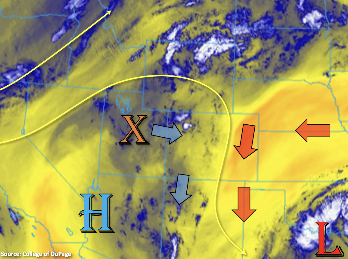
PM Update (4PM): The shortwave continues to progress to the Northeast and is currently located near the CO/UT/WY border. Lift out in front of the shortwave and southeasterly flow at the surface is producing a cumulus field over the northern Front Range, Medicine Bow and Laramie Mountains. Storms will develop along this line and move towards the northeast through this evening. An outflow boundary from the convection (south side) may push across the northern CO border later this evening. If this were to trigger any convection in the threat area below, storms could quickly become severe in the high CAPE/shear environment. In addition to large hail, strong winds and a possible tornado, storms would be located in a moisture-rich location. Dew points in the area are upper 50Fs and low 60Fs, which is extremely elevated. This would help storms that develop to produce very heavy rainfall with max 1-hour rain rates up to 2.25 inches for an hour or more. Flash flood threats would include road/small stream flooding as well as field ponding. While heavy precipitation chances are still on the lower end, this scenario warrants an upgrade to a Low flood threat. This is an overnight threat.
— Flooding is NOT expected today
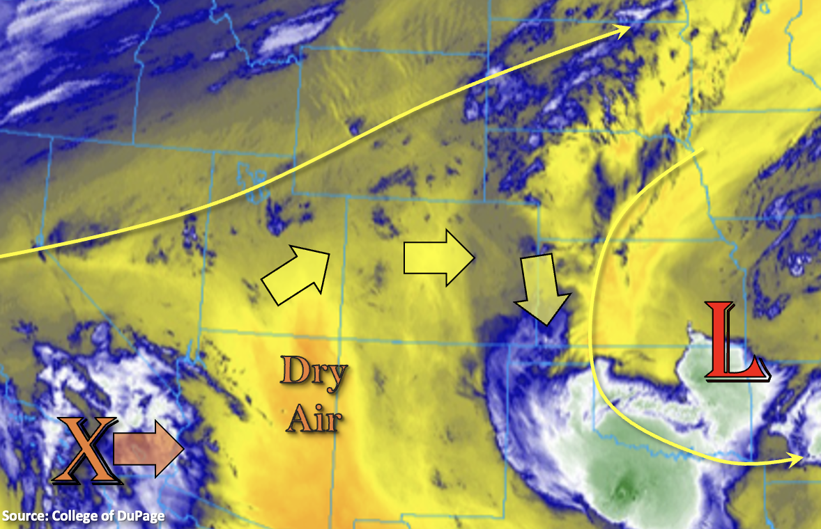
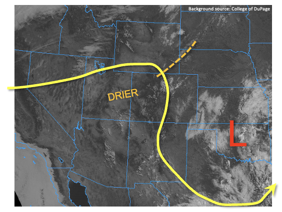
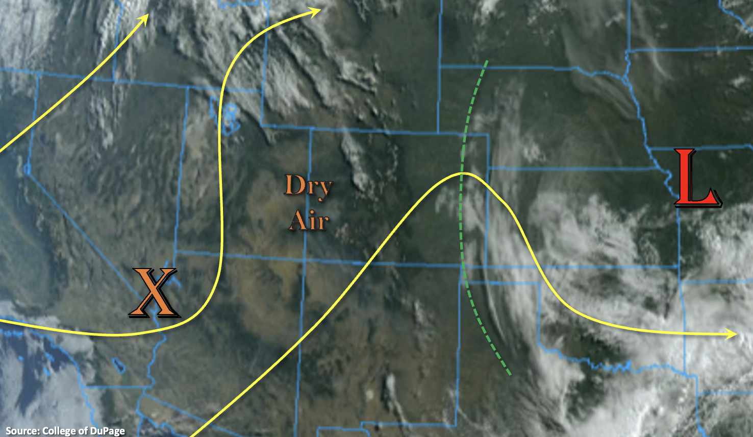
Not much change in the large-scale weather pattern today, but there are some subtle differences. Today, the shortwave that was off the coast of California will start to become absorbed into the high amplitude trough/ridge pattern (see yesterday’s FTO for more details). This mid-level lift (orange “X”) is linked to a very dry air mass (note the cloud-free conditions), and PW at Grand Junction has already dropped to 0.27 inches. The shortwave will help tighten the pressure gradient as it moves to the northeast, which in turn will increase the surface winds over western Colorado. This will produce elevated fire danger with the very low relative humidity values, so a Red Flag Warning has been issued. The drier air mass has also worked its way into the mountains and immediate adjacent, eastern plains (central and south), which will reduce the precipitation chances close to zero this afternoon.
Better moisture is located near the northern border (cloud cover in central Wyoming) and over the far eastern plains (green dashed line). That means isolated storms, producing mostly virga and wind, could pop over the northern Front Range this afternoon. Best chance for measurable rainfall from a meaningful storm will be over the Northeast Plains. This would occur if the shortwave or outflow boundaries can provide enough lift to break the cap over this region later this evening. Slow steering flow and a moisture-rich environment would mean that the storms would be capable of producing heavy rainfall. However, it looks like a strong enough cap is intact, and that the chances for this happening are low. If this scenario for evening storms becomes increasingly more likely, a PM update will be issued. For now, flooding is NOT expected.
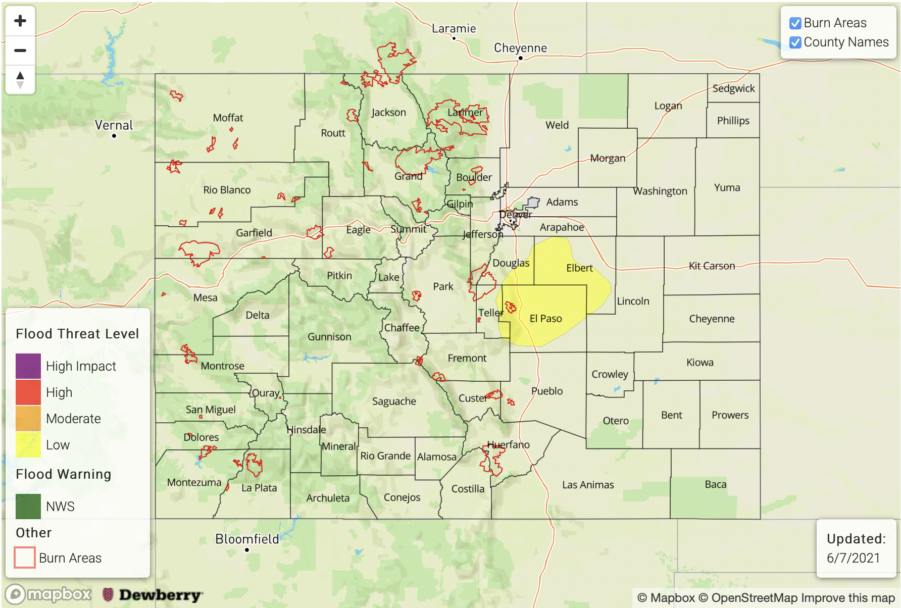
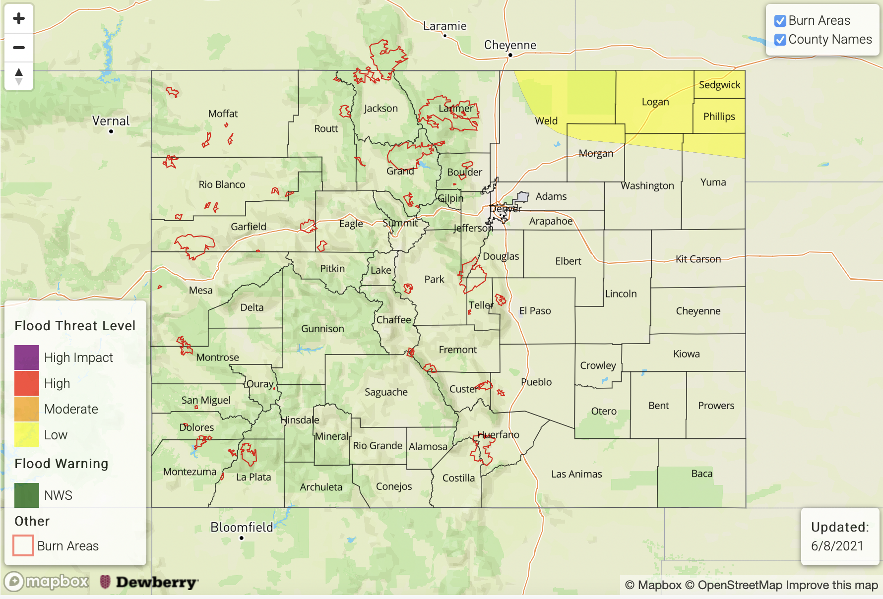
Today’s Flood Threat Map
For more information on today’s flood threat, see the map below. If there is a threat, hover over the threat areas for more details, and click on burn areas to learn more about them. For Zone-Specific forecasts, scroll below the threat map.
Zone-Specific Forecasts:
Northeast Plains & Southeast Plains:
Higher moisture exists over the eastern plains; however, there is a pretty strong cap in place. If the cap is broken over the Northeast Plains, with aid of the shortwave or an outflow boundary, heavy rainfall would occur. Max 1-hour rain rates up to 2 inches would be possible along with hail and strong outflow winds. At this time, this scenario is not looking likely enough to issue a threat, but if chances for this solution increase, a PM update will be issued. Overnight/early morning rainfall may also be possible over the northeast corner as convection rotates in from the panhandle of Nebraska. Totals between 0.50 and 0.75 inches would be most likely, but there’s low confidence in this occurring.
There may also be an isolated stray storm that forms over the Southeast Plains that pops along a convergence line. Drier air is in place, but max 1-hour rain rates up 1 inch would be possible. Flooding is NOT forecast.
Primetime: 1PM to 11PM
Southeast Mountains, Front Range, Raton Ridge, Palmer Ridge & Urban Corridor:
Hot and dry today with highs reaching into the low to mid-90Fs for the lower elevations. The Pueblo area could reach slightly above the 95F mark, and 80Fs are forecast for the mountain valleys. Measurable rainfall is most likely over the northern Front Range, but the more likely scenario is virga , sprinkles and wind. Totals will remain under 0.10 inches.
Primetime: 3PM to 10PM
Southwest Slope, Northwest Slope, San Luis Valley, San Juan Mountains, Central Mountains, Northern Mountains & Grand Valley:
A Red Flag Warning has been issued through 9PM this evening. South winds in the 10-15 mph range are forecast, and gust could reach between 30 and 40 mph. Relative humidity in the single digits means high fire danger, so use caution with any activities that could cause a spark. Rainfall is not forecast and highs should be slightly cooler than yesterday.