Issue Date: Sunday, June 6, 2021
Issue Time: 10:05AM MDT
— A LOW flood threat has been posted for the Palmer Ridge
Colorado’s weather has quickly transitioned from spring-time to summer-time dynamics. In short, this implies that more subtle features in the flow can account for the presence of heavy rainfall, but also the lack of it. This was seen on Saturday afternoon in the higher terrain east of the Continental Divide, where a couple of thunderstorms resulted in a quick 1 inch per hour or more of rainfall. This morning’s visible satellite image, below, shows a few differences from yesterday’s setup. First of all, PW is higher both at Denver (0.55 in. yesterday, 0.67 in. today) and Grand Junction (0.62 in. yesterday, 0.71 in. today). West of the Continental Divide, moisture will drop sharply this afternoon as yesterday’s lack of steering winds are replaced by 30mph drier, westerly flow. However, winds turn sharply in a southward direction right along the Continental Divide today implying areas along and east of it will experience another day or rather weak steering flow (albeit a little stronger than yesterday). Additionally, there is a more discernable forcing feature, both aloft and at the surface, currently noted over far northern Colorado and into Wyoming. At the surface, there is a pronounced wind shift from SW to N in far southeast Wyoming. This will move into Colorado later this afternoon and evening, providing a little more focus for storm activity.
Overall, we expect a few rounds of thunderstorm activity later this morning and into the afternoon. An initial round of activity is expected early in the afternoon, followed by a more organized round of storms in the late afternoon and early evening as (i) early storm complexes merge, and (ii) as the forcing feature moves across Colorado. The majority of storms will be conventional summer-time pop-up storms with short-term heavy rainfall but not much of a flood threat. However, along the Palmer Ridge, the pattern of light northerly winds aloft along with easterly boundary layer flow suggests the potential for training of storm cells, which will raise the rainfall intensity enough to warrant a Low flood threat for this region. Hail and gusty winds will also be possible with the strongest storms today.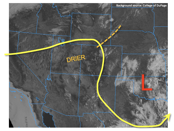
Today’s Flood Threat Map
For more information on today’s flood threat, see the map below. If there is a threat, hover over the threat areas for more details, and click on burn areas to learn more about them. For Zone-Specific forecasts, scroll below the threat map.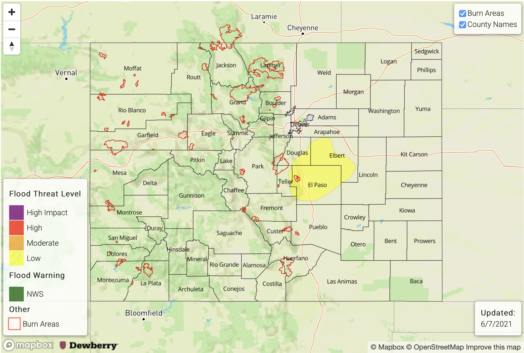
Zone-Specific Forecasts:
Palmer Ridge:
Partly cloudy and continued hot with scattered to numerous showers and thunderstorms developing later this morning and continuing into the early evening hours. Max 1-hour rainfall up to 1.3 inches possible, with max 3-hour rainfall up to 2.0 inches. A Low flood threat has been posted for this region for isolated flash flooding, debris slides and mud flows. Hail and gusty winds could also accompany the strongest storms today.
Primetime: 12PM through 9PM
Front Range, Urban Corridor, Northeast Plains, Southeast Plains, Raton Ridge, Central Mountains, Northern Mountains, San Juan Mountains, Southeast Mountains:
Continued hot with isolated to scattered showers and thunderstorms this afternoon and into early evening. Max 1-hour rainfall up to 1.4 inches (far east below 5,000 feet) and 0.8 inches (west, above 5,000 feet). Hail and gusty winds are possible with the strongest cells but flooding is NOT expected today.
Primetime: 12PM through 8PM
San Luis Valley, Grand Valley, Southwest Slope and Northwest Slope:
Continued hot and drier today but an isolated shower or storm is possible especially in the higher elevations. Max 1-hour rainfall up to 0.3 inches. A drier atmosphere along with gusty winds has resulted in a Red Flag Warning for parts of the region.
Primetime: 2PM through 7PM