Issue Date: Saturday, June 5th, 2021
Issue Time: 9:05AM MDT
— Flooding is NOT expected today
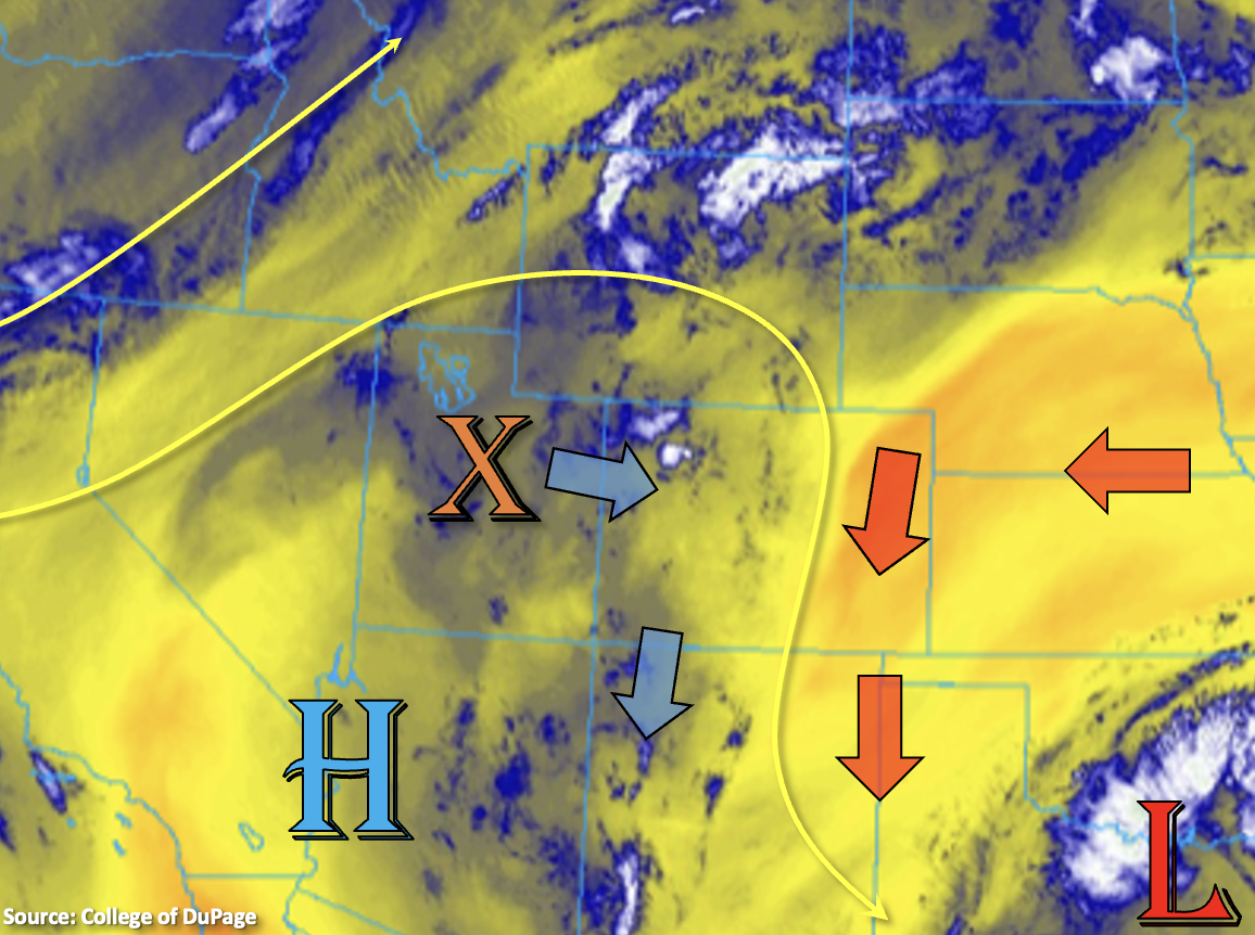
There’s a split in the weather pattern over the state today, which can be seen below in the water vapor imagery by an increase in moisture west (blue/white shades) and dry conditions across the lower elevations east (orange/yellow shades). As some mid-level energy rotates around the High (orange “X”), it will bring a slight increase in PW values west. More importantly, it looks like this increase in moisture will be in the surface layer. That will translate into more widespread storms and higher efficiency of rainfall when compared to the last couple of days.
Expect numerous storms to fire by early afternoon over the mountains and elevated plateaus as the shortwave moves overhead and combines with the diurnal flow. For the most part, rainfall cores should be small in area and will likely pulse in intensity. Storms that form over the mountains east of the Continental Divide are expected to slowly drift eastward with the disturbance. However, as they move off the mountains and into the adjacent plains this evening, they will encounter that aforementioned dry air mass. Thus, storms should rapidly dissipate and pose more of a wind than rainfall threat.
Overall for rainfall today, there’s still a decent spread in the temperature and dew point over the mountains and west. So brief, heavy rainfall may be possible in the storm cores, but only moderate rainfall totals are forecast. Once again, the main threat from the stronger storms that develop should be gusty outflow winds; although, dangerous lighting and small hail are also possible. Flooding is NOT forecast.
Today’s Flood Threat Map
For more information on today’s flood threat, see the map below. If there is a threat, hover over the threat areas for more details, and click on burn areas to learn more about them. For Zone-Specific forecasts, scroll below the threat map.
Zone-Specific Forecasts:
Central Mountains, Northern Mountains, Southeast Mountains, San Juan Mountains & Front Range:
Numerous scattered storms will develop by midday over the mountains regions as the shortwave increases lift and moisture over the area. Storms will be small in area size this afternoon/evening and are expected to pulse in intensity. Brief, heavy rainfall in the cores will be possible with isolated max 1-hour rain rates up to 0.60 inches. The majority of storms will produce between 0.25 and 0.40 inches of rainfall. Strong outflow winds, lightning and hail will be the main threat from the stronger storms that develop. These outflow boundaries may help trigger additional convection. Storms should start to come to an end a couple hours after sundown with all activity ending by midnight. Flooding is NOT forecast.
Primetime: 11:30AM to Midnight
Southwest Slope, Northwest Slope, San Luis Valley & Grand Valley:
It’s going to be another hot day ahead with temperatures similar to yesterday (mid to upper 90Fs). It might not be quite as hot over some areas if a cool outflow boundary can knock a couple degrees off late this afternoon. Storm development over the mountain and ridges will be more widespread this afternoon and some rainfall may occur 1) if storms push off the mountains into the valleys and 2) if outflow boundaries collide to trigger additional convection. The main threat from those storms will be wind and lightning. Totals should remain around 0.10 inches, so flooding is NOT forecast.
Primetime: 11:30AM to 10PM
Southeast Plains, Northeast Plains, Raton Ridge, Palmer Ridge & Urban Corridor:
Summer temperatures return with 90F+ forecast across the I-25 corridor and eastern plains. Mountain valleys should reach into the upper 70Fs and may perhaps cross the 80F marker. The cut off low will reinforce the dry air over these regions. So, as storms move off the mountains this evening, expect them to dissipate quickly and produce gusty outflow winds. Plenty of virga means totals will remain under 0.05 inches except over the Palmer Ridge where isolated totals may reach up to 0.15 inches.