FTB 09-12-2021: Scattered Storms Return & A Couple Severe Storms Possible East

Issue Date: Sunday, September 12th, 2021
Issue Time: 9:50AM MDT

— Flooding is NOT expected today

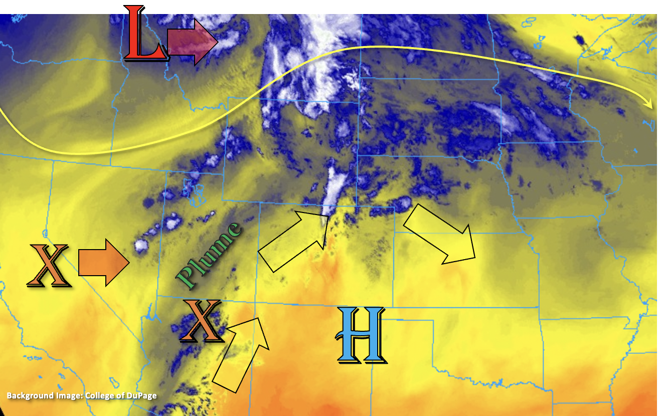
With the High suppressed to our south and a few shortwaves moving through the flow, the 500mb pattern has become more zonal across the state this morning. This more westerly flow aloft will allow another shortwave, marked below, to move across the state and increase mid-level lift for scattered storm development. In the wake of yesterday’s trough, a weak cold front has pushed through the eastern plains. With a slight increase in overall moisture, upslope flow, and uptick in lift from the shortwave, scattered storms are expected to develop over the northern and central mountains by midday. As these storms are steered into the adjacent eastern plains, they should encounter a little deeper surface moisture along with some marginal shear. This should allow the storms to expand in both coverage and intensity over the border counties, and one or two severe storms may be possible. The main threats from these severe storms would be large hail and strong outflow winds.

Steering flows do look to be a little slower than yesterday, which should help encourage higher local accumulations from the storms today. However, less surface moisture back to the west means that storms will likely produce more of a wind threat than heavy rainfall over the mountains and immediate adjacent plains. Although, dew points over the far eastern plains should remain in the low to mid-50Fs, steering flow should be quick enough to keep rainfall rates just below flood threat criteria. Therefore, flooding is not expected today.

Today’s Flood Threat Map

For more information on today’s flood threat, see the map below. If there is a threat, hover over the threat areas for more details, and click on burn areas to learn more about them. For Zone-Specific forecasts, scroll below the threat map.

Zone-Specific Forecasts:

Front Range, Central Mountains, Northern Mountains & Northwest Slope:

Cooler afternoon temperatures are forecast today with storms kicking of just after noon favoring the Front Range and Northern Mountains for development. Similar to yesterday, storms should pulse in intensity as they develop and fairly quickly dissipate or move out of the area. Max 1-hour rain rates up to 0.25 inches will be possible. In addition to rainfall, storms will likely produce gusty outflow winds, especially over the Front Range. Flooding is NOT expected today.
Primetime: 12:30PM to 9PM 

Northeast Plains, Southeast Plains, Urban Corridor, Raton Ridge & Palmer Ridge:

As storms move east and off the mountains, they will begin to encounter slightly higher surface moisture. This should allow storms to increase in intensity, especially east of I-25. Over the adjacent plains (Urban Corridor), best coverage of the stronger storms will be north, especially along the Palmer Ridge. Max 1-hour rain rates up to 0.50 inches will be possible. South, max 1-hour rain rates up to 0.20 inches will be possible.

A couple marginal severe storms may be possible this evening as storms make their way into the far eastern plains with the main threats being strong outflow winds (50 to 55 mph) and large hail (1.25 inches). Best chance for this to happen will be north of southern Kiowa County border. Max 1-hour rain rates up to 1.50 inches will be possible with the stronger storms that develop, and storm intensity should begin to drop off around 9PM. However, some showers may linger overnight. Flooding is NOT expected today.
Primetime: 2PM to 1:30AM

Grand Valley, San Juan Mountains, Southeast Mountains, San Luis Valley & Southwest Slope:

It’s expected to remain dry over the lower elevations of these forecast zones today with isolated storm development over the San Juan and Southeast Mountains this afternoon. Best chance for measurable rainfall will be along and near the Continental Divide where isolated storm totals up to 0.20 inches will be possible. High temperatures will drop into the upper 80Fs (lower elevations) with 70Fs for the mountain valleys. Flooding is NOT expected.

FTB 09-11-2021: Scattered Storms Return to the Forecast, Minimal Rainfall Expected

Issue Date: Saturday, September 11th, 2021
Issue Time: 9:15AM MDT

— Flooding is NOT expected today

Isolated to scattered storms return to the forecast today as subtropical moisture and mid-level energy move across the state. The ridge, that has been bringing us dry and hot weather the last few days, will start to break down over the next 24-hours from incoming shortwaves associated with a trough to our north. Even with the breakdown of the ridge beginning, another day of hot temperatures are forecast statewide. Currently, south/southwest flow aloft around the High has brought some subtropical moisture northward into the state (blue in the water vapor image below). Looking at this mornings’ soundings, PW has risen to 0.68 inches and 0.53 inches in Grand Junction and Denver, respectively. This should increase a little more throughout the day (west), and it is expected to combine with mid-level energy and the diurnal flow to produce scattered storms mostly along and north of I-70.

Despite the return of storms and rainfall, there will be two limiting factors to the flood threat today. The first is a very dry boundary layer, which will cause storms to produce more wind than rainfall. The second factor will be very fast steering flows (20-30 mph), which should keep storms from accumulating meaningful rainfall over any given area. Therefore, flooding is NOT expected. Dry thunderstorms are also a concern this afternoon and evening, which will increase in fire danger with lightning and gusty outflow winds forecast. It has gotten dry over the last few weeks, especially with the very hot temperatures we saw this last week. A Red Flag Warning has been issued for the Northwest Slope and Northern Mountains from noon to 9PM today.

Today’s Flood Threat Map

For more information on today’s flood threat, see the map below. If there is a threat, hover over the threat areas for more details, and click on burn areas to learn more about them. For Zone-Specific forecasts, scroll below the threat map.

Zone-Specific Forecasts:

Grand Valley, Northwest Slope, Northern Mountains, Front Range, Central Mountains, Northeast Plains, Urban Corridor & Palmer Ridge:

Best chance for storms today will be along and north of I-70. Some isolated, high-based showers may be possible just south of this area along and near the Continential Divide and Palmer Ridge. For the most part, storms will be quick moving and produce little rainfall/plenty of outflow winds as they travel to the northwest. Training storms over the Northwest Slope and Northern Mountains will help produce slightly higher accumulations, and isolated storm totals up to 0.40 inches will be possible by morning. Elsewhere, max 1-hour rain rates should remain around or below 0.25 inches for a brief period. A Red Flag Warning has been issued for the Northwest Slope and the Northern Mountains where dry thunderstorms are expected to produce lightning and strong outflow winds from noon to 9PM. Some linger lighter showers may be possible over the northwest corner of the state tonight. Flooding is NOT expected today.
Primetime: 2PM to Midnight

Southeast Mountains, Southeast Plains, San Juan Mountains, Raton Ridge, San Luis Valley & Southwest Slope:

A couple high based storms may develop over the Raton Ridge area this afternoon, but more cloud cover than rainfall is expected. Elsewhere, dry conditions are forecast with another round of hot temperatures expected with the center of the High near the area. Expect daily record highs to be broken once again.

FTB 09-10-2021: Record Breaking Heat & Isolated High-Based Storms

Issue Date: Friday, September 10th, 2021
Issue Time: 9:15AM MDT

— Flooding is NOT expected today

A change in the weather pattern is on its way, but before that, we have a very hot September day ahead. An incoming trough to our west will begin to move the center of the High slightly southward, but the ridging pattern will be able to hold on for one more day. This will help to produce daily record heat with a handful of areas nearing all-time monthly records. With the slight southward movement of the High from the incoming shortwave, a little mid-level energy and moisture has and will continue to move through the state. The combination of the two with the diurnal flow may produce some weak, isolated showers over the southern high terrains this afternoon and over the Northwest Slope later tonight. More virga than wetting rainfall is forecast with the high cloud bases, so accumulations should remain very light. Therefore, flooding is NOT forecast. As far as near surface smoke, it’s thickest this morning over the lower elevations of eastern Colorado. It should mix out throughout the day leading to blue skies for most. The one exception is over the far northeast corner of the state where visibility is forecast to remain in the 10 to 30 mile range.

Today’s Flood Threat Map

For more information on today’s flood threat, see the map below. If there is a threat, hover over the threat areas for more details, and click on burn areas to learn more about them. For Zone-Specific forecasts, scroll below the threat map.

Zone-Specific Forecasts:

Southeast Mountains, Front Range, Southeast Plains, Northeast Plains, Raton Ridge, San Luis Valley, Urban Corridor & Palmer Ridge:

It will likely be the last scorcher of the year today with mercury levels on the rise. High temperatures over the far eastern plains will reach 100F+ with high 90Fs for the I-25 Corridor. The San Luis Valley should reach around 90F with mountain towns in the 80Fs. A couple high based showers may be possible south this afternoon, but more cloud cover than wetting rainfall is forecast. Flooding is NOT expected today.

San Juan Mountains, Central Mountains, Northern Mountains, Southwest Slope, Grand Valley & Northwest Slope:

There will be a nice break from the near surface smoke today, and highs across the Grand Valley are forecast to reach into the mid-90Fs. Most of the lower elevations will reach into the low 90Fs with 80Fs forecast for the mountain valleys. As for rainfall, there might be an isolated, high-based shower over the San Juan Mountains this afternoon, and tonight, some high-based showers may clip the far northwest corner of the state. With more cloud cover than wetting rainfall forecast, flooding is NOT expected. Storms tonight over the Northwest Slope may produce some brief windy conditions as they become outflow driven.

FTB 09-09-2021: Dry & Hot Weather Continues

Issue Date: Thursday, September 9th, 2021
Issue Time: 8:10AM MDT

— Flooding is NOT expected today

It’s going to be another hot and dry day statewide. High temperatures will be on the rise with the strengthening ridge overhead. Highs for the lower elevations over eastern Colorado will reach into the mid-90Fs (north) to upper 90Fs (south). Low to mid-90Fs are forecast across the lower elevations of western Colorado, and finally, mountain valleys will reach the upper-70Fs to mid-80Fs. Near surface smoke this morning continues to be thick over the Northern/Central Mountains, Northwest Slope and Grand Valley. This should mix out throughout the day, and expect an increasing near surface smoke forecast over the I-25 Corridor and adjacent eastern plains by mid-afternoon. With PW measured around 0.35 inches at both Grand Junction and Denver, and stable conditions statewide with the High moving into the Four Corners region, rainfall is not forecast today.

Today’s Flood Threat Map

For more information on today’s flood threat, see the map below. If there is a threat, hover over the threat areas for more details, and click on burn areas to learn more about them. For Zone-Specific forecasts, scroll below the threat map.

Zone-Specific Forecasts:

Southeast Mountains, Front Range, Southeast Plains, Northeast Plains, Raton Ridge, Urban Corridor & Palmer Ridge:

Clear start to the day, and it’s going to be a hot one with daily records likely broken both today and tomorrow. Highs will reach the upper 90Fs over the eastern plains with mid to upper 90Fs over the Urban Corridor. It’s going to get smoky throughout the day over these lower elevation forecast regions with smoke mixing out over the mountains. Highs over the Front Range and Southeast Mountains will reach into the 80Fs. Rainfall is not forecast.

San Juan Mountains, Central Mountains, Northern Mountains, Southwest Slope, San Luis Valley, Grand Valley & Northwest Slope:

Thick near surface smoke this morning will begin to mix out and move east throughout the day. So, expect conditions to clear a bit by mid-afternoon, and hopefully you’ll see some blue skies. Highs will reach into the mid 90Fs over the Grand Valley with 90Fs for other lower elevation valleys. Mountain valleys will reach into the upper 80Fs. It will be too dry and stable for any rainfall, so flooding is not expected.