FTB 09-28-2021: Widespread Precipitation Forecast for the Mountains and Western Colorado

Issue Date: Tuesday, September 28th, 2021
Issue Time: 10:25AM MDT

— Flooding is NOT expected today

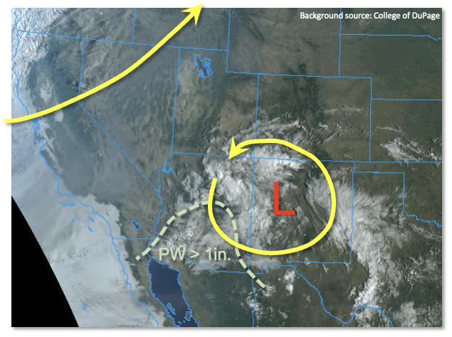
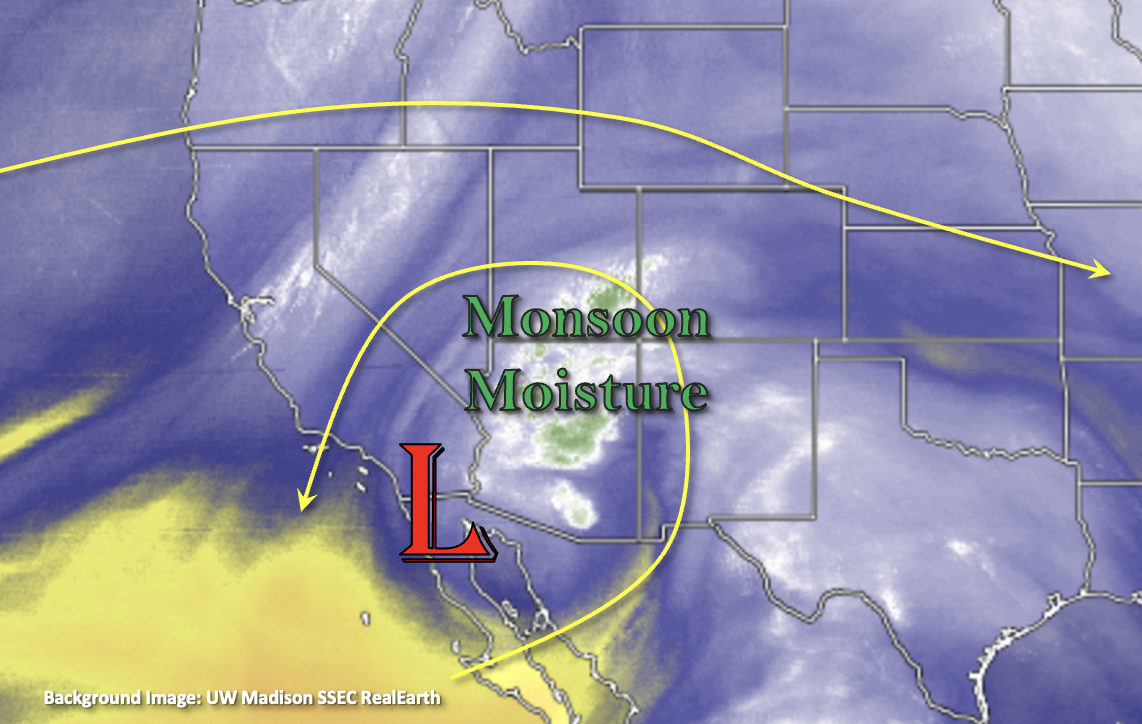
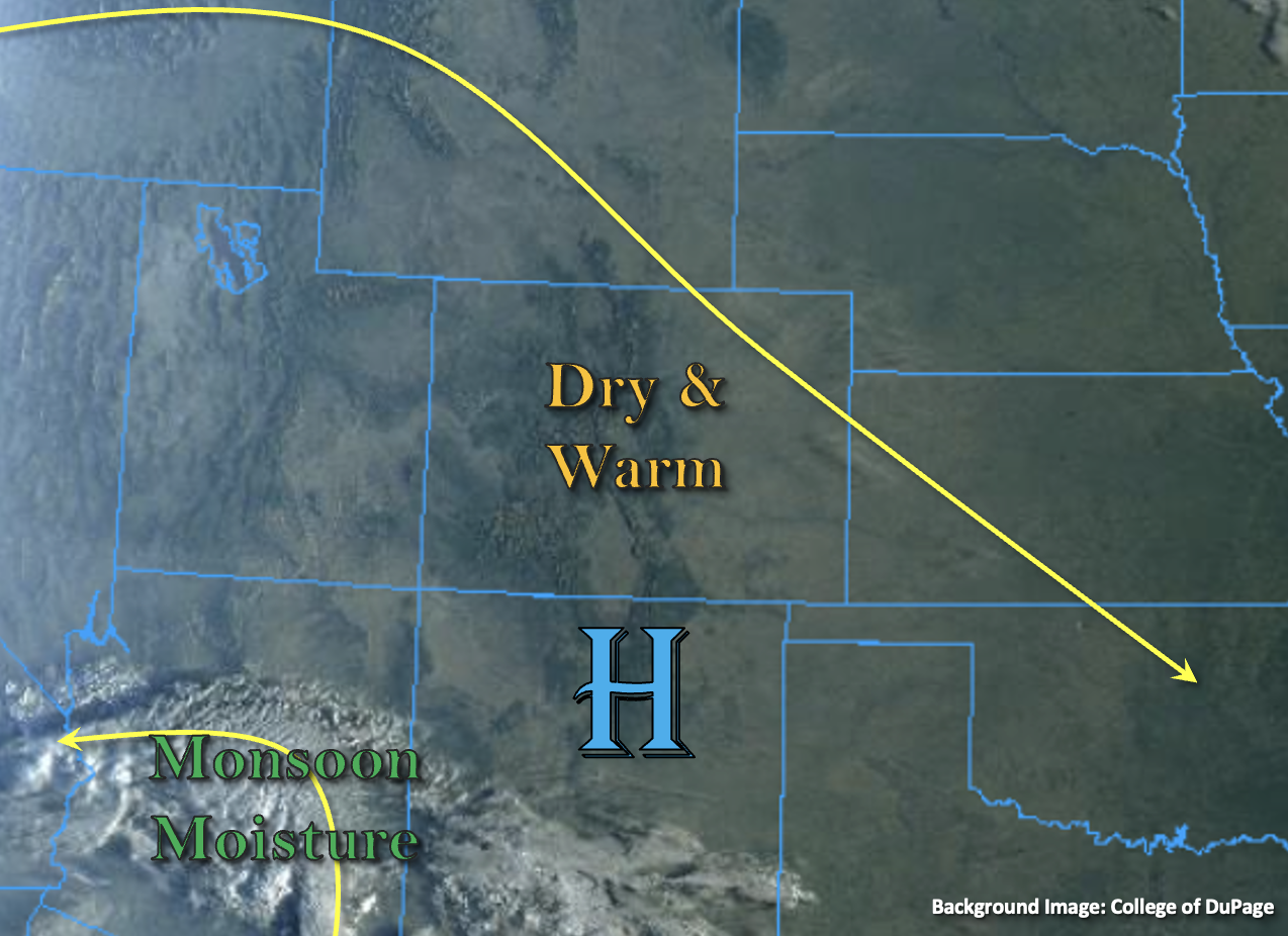
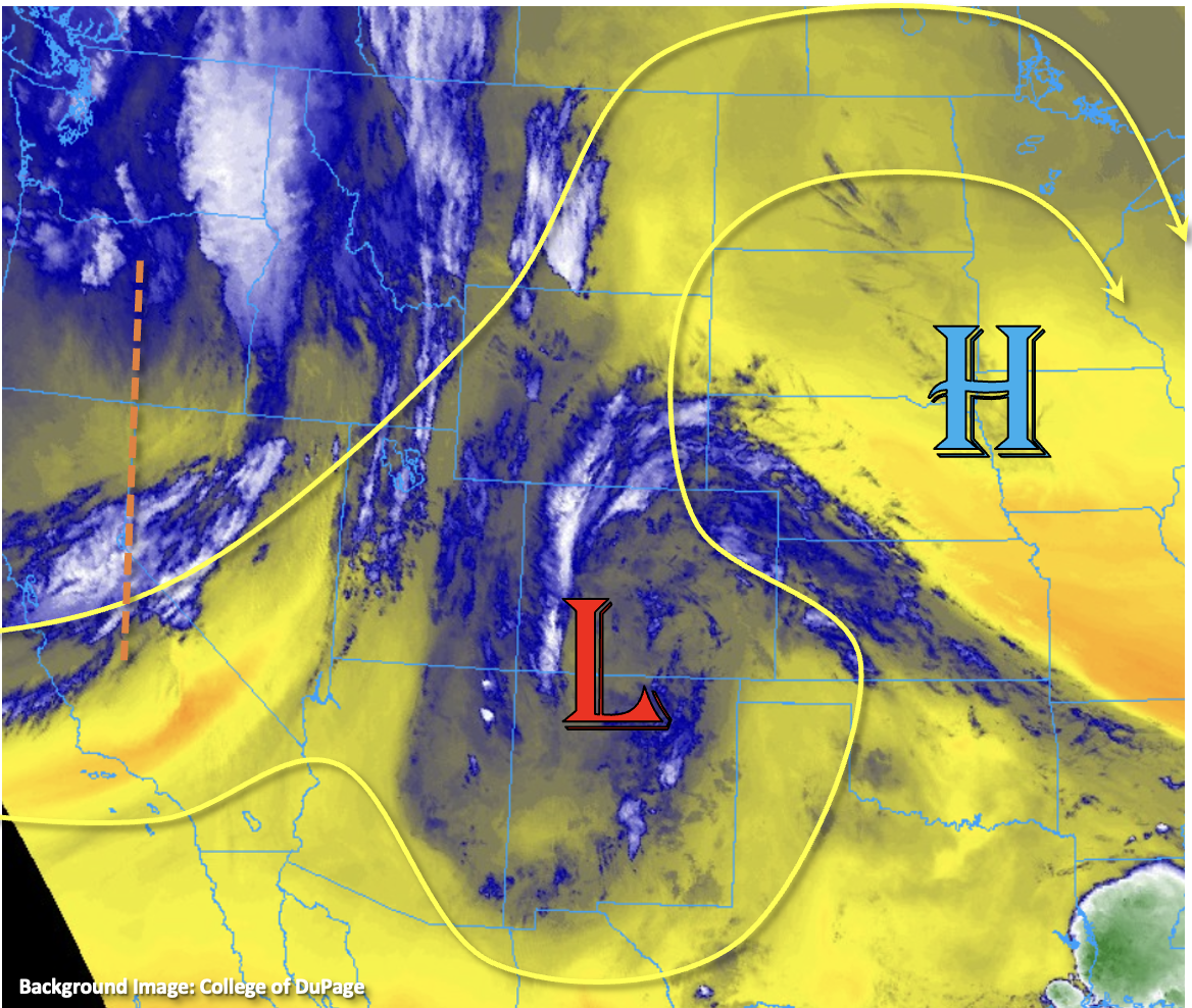
Currently, there’s a hearty plume of late season moisture over the state associated with the cutoff Low (blue and white shades in the water vapor imagery below). This moisture and lift from the Low are helping to produce some morning, scattered cloud cover as well as some isolated, weak showers over the elevated regions of western Colorado. This cutoff Low is expected to track NNE throughout the day, so moisture and lift are expected to remain over the state. The Low may also generate some weak showers over the plains this afternoon, but only light rainfall accumulation is expected. With the plume overhead, PW at Grand Junction has risen to whopping 0.83 inches, which is close to the 95th percentile for this date. Over Denver, PW has risen more modestly to 0.68 inches, but that’s still in the 90th percentile for this time of year. That means there is more than enough moisture for widespread precipitation to develop over the mountains and western Colorado this afternoon and evening. An incoming trough from our west (orange dashed line) will also help increase lift and perhaps add a little more moisture later this evening over western Colorado. So, expect a second round of precipitation to arrive to the western border later this evening and continue through tomorrow morning as the trough axis moves east.


There are a few things that should limit the flood threat today. The first is that both soundings still show a relatively dry surface layer. That means that the initial storms that develop this afternoon will likely produce some brief windy conditions, and higher cloud bases should help temper rainfall rates. The second is that CAPE values are expected to be on the lower end, which will limit the convective/downpour potential of storms. More stationary storms, as well as the possibility for multiple storm cores tracking over the same area, are expected to increase local totals; however, dry soils should be able to absorb most of the precipitation and limit the runoff. With instability dropping off quite a bit after sundown, overnight precipitation is expected to only produce moderate hourly rainfall rates. Additionally, colder overnight temperatures are expected, which should help turn rainfall to snow over the highest elevations. For these reasons, flooding is NOT expected today. This event should be a much needed, widespread soaking for the mountains and western Colorado.

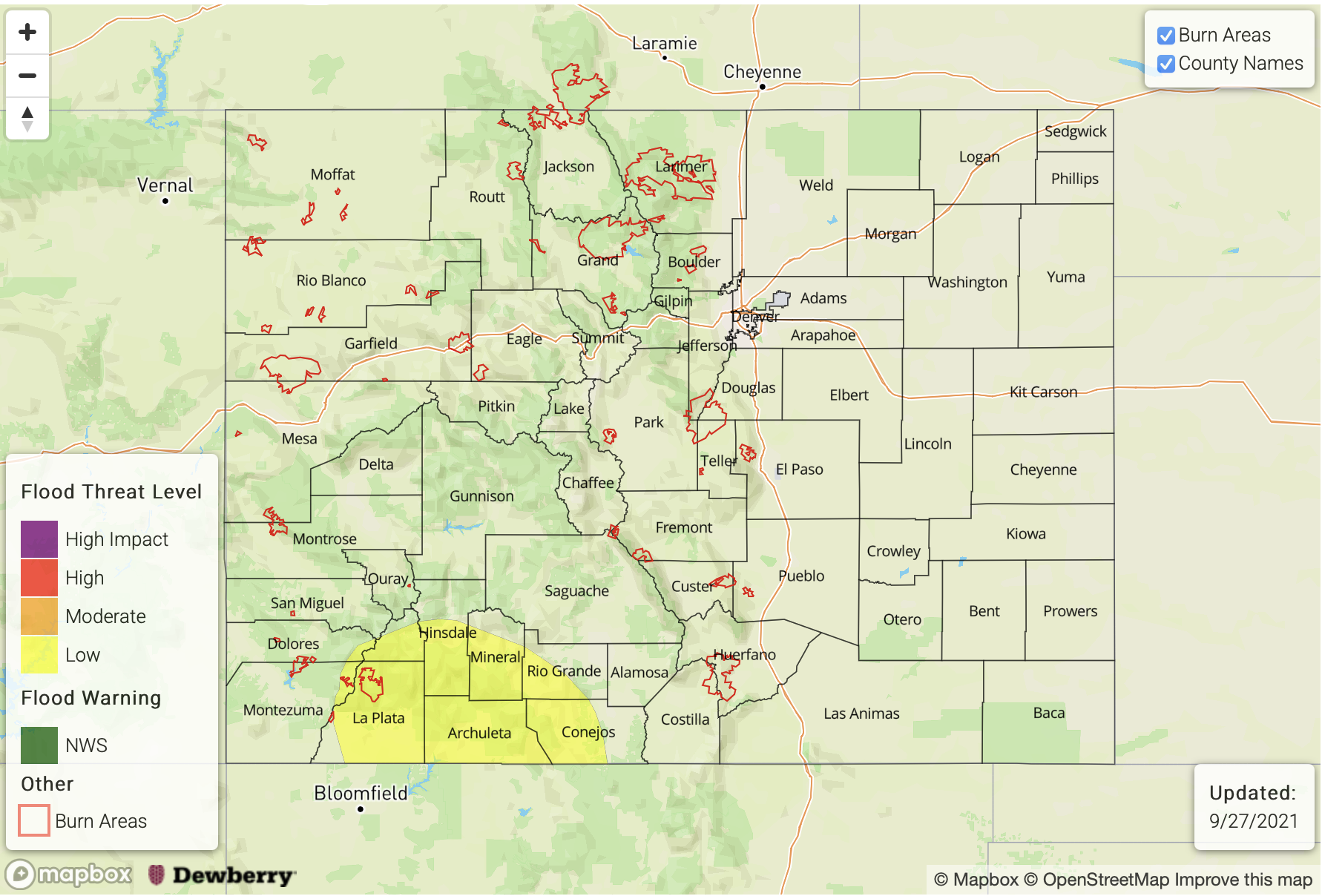
Today’s Flood Threat Map:

For more information on today’s flood threat, see the map below. If there is a threat, hover over the threat areas for more details, and click on burn areas to learn more about them. For Zone-Specific forecasts, scroll below the threat map.

Zone-Specific Forecasts:

San Juan Mountains, Front Range, Central Mountains & Northern Mountains:

Widespread showers should develop by early afternoon. Minimal CAPE and more pop like storms should limit the flood threat, although some decent, but isolated, storm totals will be possible by morning. The reason for the higher storm totals is that a second round of overnight precipitation is forecast as the trough axis moves overhead. Some snow will likely fall at the top of the highest peaks. Max 1-hour rain rates up to 0.65 inches will be possible this afternoon, and isolated 2-3 hour totals up to 1.75 inches are forecast by morning (Central/San Juan Mountains). Flooding is NOT expected today.
Primetime: 11:30AM to Ongoing

Grand Valley, Northwest Slope & Southwest Slope:

Best chance for some afternoon storms will be over the elevated plateaus/mesas and Southwest Slope. A second round of precipitation is expected overnight, which will likely help bring measurable precipitation to the lower elevations of the Grand Valley and Northwest Slope. Max 1-hour rain rates up to 0.50 inches and isolated 2-3 hour totals up to 1 inch will be possible. Flooding is NOT expected.
Primetime: 11:30AM to Ongoing

Southeast Mountains, San Luis Valley, Urban Corridor, Northeast Plains, Southeast Plains, Raton Ridge & Palmer Ridge:

It will be a bit drier over the Southeast Mountains/Raton Ridge and San Luis Valley today; however, isolated storms are still likely to develop. Max 1-hour rain rates up to 0.25 inches will be possible over the Southeast Mountains/Raton Ridge and storm totals up to 0.15 inches can be expected over the SLV. Light showers may also be generated over the eastern plains as the Low moves overhead. Rainfall accumulation over the plains should be light, with totals remain at or under 0.15 inches.
Primetime: 1PM to 9PM

FTB 09-27-2021: Isolated Heavy Rainfall Threat Returns To Southwest Colorado

Issue Date: Monday, September 27th, 2021
Issue Time: 10:18AM MDT

— A LOW flood threat has been posted for parts of the San Juan Mountains

Although cut-off lows usually require meteorologists to carry extra ibuprofen, we still secretly like them. This morning’s visible satellite image, below, shows a distinct cut-off circulation over western New Mexico responsible for ongoing showers and weak thunderstorms over a large swath of the Four Corners region. The low has moved slowly eastward since yesterday morning, has deepened a bit and will continue to do so as it begins to feel the synoptic scale lift from a strong incoming trough further to the northwest. Notably colder temperatures aloft have now moved into New Mexico and will enter southwest Colorado today. Yesterday’s QPE up to 0.50-0.75 inches over the San Juan Mountains carried max hourly rain rates of up to a rather impressive 0.5 inches with very limited instability and moisture. In addition, isolated heavy rainfall, near 1.5 inch/hour, was observed over central AZ higher terrain yesterday. Thus, we expect that today’s rainfall intensity will very likely be higher over southwest Colorado. This morning’s Precipitable Water (PW) was 0.61 inches at Grand Junction and 0.48 at Denver. A PW of 0.78 inches was measured at both Albuquerque and Flagstaff, and boundary layer moisture advection will be from the southwest today. Thus, we expect PW up to 0.7-0.85 in the far southwestern portion of the state. With the aforementioned cooling aloft, instability up to 1,000 J/kg will be possible this afternoon especially over areas that see some breaks in cloud cover as is expected. Steering winds will be modest, in the 20-25mph range and will be pushing storms towards the west.

Translating everything into sensible weather, with the strengthening cut-off low, we expect several rounds of showers and thunderstorms over southwest Colorado today. During the afternoon and early evening, there will be a chance for heavy rainfall over the San Juan Mountains roughly south of a South Fork-Silverton line. A LOW flood threat has been posted for this region.

Elsewhere, expect one more day of significantly above normal temperatures before cooling overtakes the state starting tomorrow and especially Wednesday.

Today’s Flood Threat Map

For more information on today’s flood threat, see the map below. If there is a threat, hover over the threat areas for more details, and click on burn areas to learn more about them. For Zone-Specific forecasts, scroll below the threat map.

Zone-Specific Forecasts:

San Juan Mountains, Southwest Slope, Southeast Mountains and San Luis Valley:

Mostly cloudy with numerous showers and thunderstorms developing later this morning and persisting into the late evening hours. Max 1-hour rainfall up to 1.1 inches, with max 3-hour rainfall up to 1.5 inches, warranting a LOW flood threat for parts of the region. Isolated flash flooding, mud flows and debris slides will be possible especially over steeper terrain. Gusty winds and hail up to 1 inch could also accompany the very strongest storms.

Primetime: 2PM through 11PM

Front Range, Urban Corridor, Northeast Plains, Southeast Plains, Palmer Ridge and Raton Ridge:

A few clouds this afternoon, along with continued very warm temperatures up to 12F above normal. An isolated shower cannot be ruled out over southern areas later this evening and into the overnight hours. However, flooding is NOT expected today.

Northwest Slope, Grand Valley, Central Mountains and Northern Mountains:

Partly cloudy with temperature slightly above seasonal normal. An isolated shower or weak storm cannot be ruled out this afternoon and evening over far southern areas, but flooding is NOT expected today.

FTB 09-26-2021: Scattered Storms Return to Southwest Colorado

Issue Date: Sunday, September 26th, 2021
Issue Time: 9:10AM MDT

— Flooding is NOT expected today

Finally, there’s a change in the weather pattern today. The cutoff Low, from a few days back, will start to meander to the northeast and center itself on the New Mexico/Arizona border by tomorrow morning. There’s a good lump of monsoon moisture being circulated around the Low, which can be seen by the white/green shades in the water vapor imagery below. This moisture plume is expected to continue to move into the far southwest corner of the state and help spark some scattered afternoon and evening storms over the high terrains in the area.

Soundings out of Flagstaff and Albuquerque show robust moisture throughout the atmospheric column, so that likely means more widespread coverage of rainfall with a couple weak thunderstorms possible over the southwest corner. With the dryness of the air mass overhead from the few days, it’s likely that it will take a bit to moisten the boundary layer. Slower steering flows should help do this, so anticipating an increase in rainfall rates and accumulations by early this evening. Rainfall rates should remain just under flood threat criteria and dry soils are expected to absorb much of the rainfall and subsequent runoff. So, outside of nuisance road and low-lying area ponding, flooding is NOT expected.

Elsewhere, dry northwest and westerly flow aloft is forecast, which should keep precipitation chances near zero and allow temperatures to continue to rise. Afternoon high temperatures will make today feel more like summer than fall. High clouds will likely develop as the moisture plume moves northeast this afternoon into tomorrow morning.

Today’s Flood Threat Map

For more information on today’s flood threat, see the map below. If there is a threat, hover over the threat areas for more details, and click on burn areas to learn more about them. For Zone-Specific forecasts, scroll below the threat map.

Zone-Specific Forecasts:

Southeast Mountains, San Juan Mountains & Southwest Slope:

Scattered storms will return to the southwest high terrains this afternoon and evening with a couple high-based showers possible over the Southeast Mountains. Accumulations over the Southeast Mountains should remain under 0.15 inches. Over the high terrains of the Southwest Slope and San Juan Mountains, max 1-hour rain rates up to 0.80 inches per hour and isolated accumulations up to up to 0.90 inches will be possible. In addition to moderate rainfall, storms may produce some strong outflow winds and small hail. Outside of nuisance ponding, flooding is NOT expected. Storms should end as instability drops off with the setting sun.
Primetime: 2PM to 9:30PM

Central Mountains, Northern Mountains, Grand Valley, Northwest Slope & San Luis Valley:

Anticipate an increase in mid and high cloud cover (south to north) this afternoon and into tomorrow, but today should remain dry. Afternoon high temperatures will likely reach into the mid to upper 80Fs for the Grand Valley and upper 70Fs for the mountain valleys. Flooding/rainfall is NOT expected.

Front Range, Urban Corridor, Northeast Plains, Southeast Plains, Raton Ridge & Palmer Ridge:

It’s going to be a hot day ahead with highs reaching into the upper 80Fs (adjacent plains) and 90Fs (eastern plains). Mountain valley locations will likely reach the 80F marker. High cloud cover is anticipated to move in this afternoon and overnight associated with the moisture plume to our southwest. Rainfall is not forecast, so there is NO flood threat issued.

FTB 09-25-2021: Heating Up with Dry Conditions Continuing

Issue Date: Saturday, September 25th, 2021
Issue Time: 8:50AM MDT

— Flooding is NOT expected today

High pressure will continue to build across the state today with the ridge axis sliding overhead by this evening. This will help to produce warmer temperatures with highs today generally running 7F to 12F above normal. The visible satellite imagery below shows no clouds over the state, which exemplifies the dryness of the air mass. PW was measured just above 0.40 inches at Denver and Grand Junction this morning, which means that it will be too dry, once again, for any rainfall to develop. Breezy conditions are forecast over the eastern plains through early afternoon, and westerly/northwesterly surface winds are forecast to pick up over the mountains by this afternoon (north/central). This may elevate fire weather conditions for a brief window this afternoon into this evening.

Over the far southwest corner of the image below, monsoon moisture has started to move counterclockwise around an upper-level Low. This is the same disturbance that cut itself off from the main flow a couple days back. This moisture plume is expected to stay south of the border today, although some mid and high level clouds will likely move into the southwest corner of the state overnight. With only some broken cloud cover forecast over the southern high terrains by later this afternoon, flooding is NOT expected.

Today’s Flood Threat Map

For more information on today’s flood threat, see the map below. If there is a threat, hover over the threat areas for more details, and click on burn areas to learn more about them. For Zone-Specific forecasts, scroll below the threat map.

Zone-Specific Forecasts:

Southeast Mountains, Front Range, Urban Corridor, Northeast Plains, Southeast Plains, Raton Ridge & Palmer Ridge:

It’s going to be a hot day by late September standards. Highs across the lower elevations will reach into the mid to upper 80Fs with mid to upper 70Fs for the mountain valleys. Outside of some afternoon cloud cover over the southern Front Range and Southeast Mountains, it should be clear day ahead. So, NO flood threat is issued. Breezy conditions are forecast over the far eastern plains through early afternoon with south and southwesterly winds reaching between 10 and 18 mph. By this afternoon, westerly and northwesterly winds will pick up over the Front Range reaching between 10 and 15 mph. This may cause elevated localized fire weather conditions.

Central Mountains, Northern Mountains, San Juan Mountains, Grand Valley, Northwest Slope, San Luis Valley, & Southwest Slope:

Highs today will reach into the upper 80Fs for the Grand Valley and into the 80Fs for other valley locations. Mountain valleys could reach into the mid 70Fs. No rainfall is forecast today, although some mid and upper level cloud cover is expected to move into the southwest corner of the state overnight. This should help keep overnight low temperatures a little warmer for the region. Breezy afternoon conditions should be anticipated over portions of the Northern/Central Mountains and Northwest Slope where surface winds could gust up to 30 mph (Northern Mountains). With the dry air overhead, this will likely elevate local fire weather conditions. Flooding is NOT forecast today.