Issue Date: 5/07/2015
Issue Time: 10:59 AM
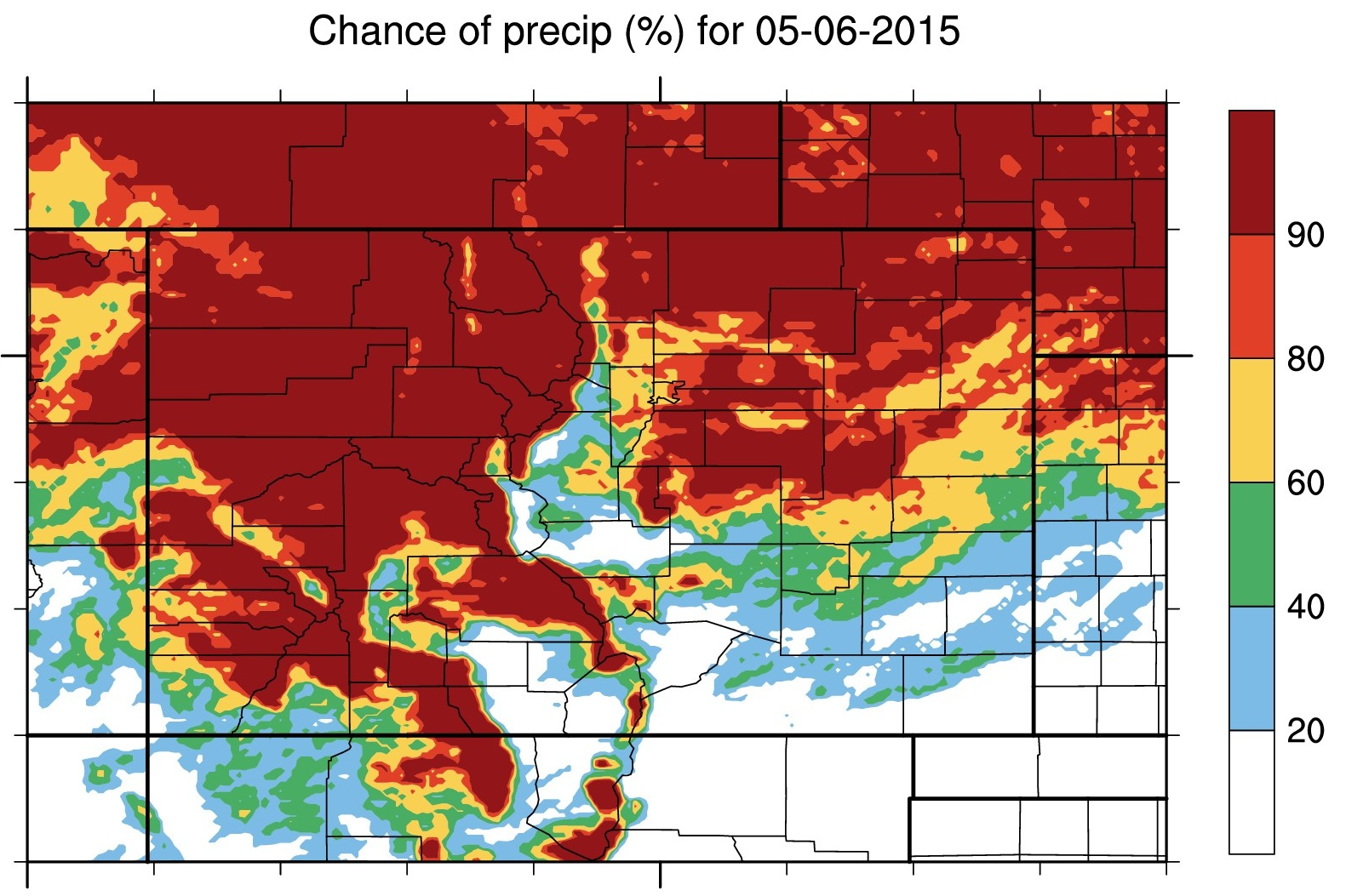
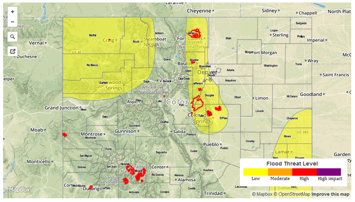
A MODERATE FLOOD THREAT IS FORECAST FOR PORTIONS OF THE URBAN CORRIDOR, FRONT RANGE, PALMER RIDGE, AND NORTHEAST PLAINS. A LOW FLOOD THREAT IS FORECAST FOR PORTIONS OF THE NORTHWEST SLOPE, NORTHERN MOUNTAINS, CENTRAL MOUNTAINS, FRONT RANGE, PALMER RIDGE AND SOUTHEAST PLAINS.
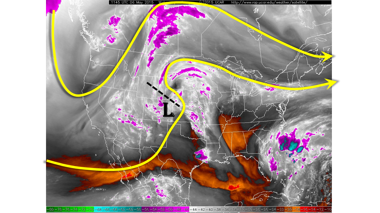
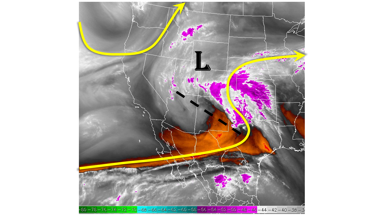
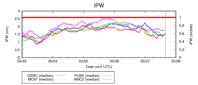
The Flood Threat Bulletin is starting to sound a lot like a broken record over the past few days, and the same tune is playing again today. Precipitable water values are in 85th percentile for this date (per this morning’s Denver and Grand Junction soundings) and the IPW graph below shows just how steady the moisture has been.
With that being said, moisture west of the Divide will be less than the previous few days, leading to less potential for heavy rain and shorter duration storms. A few showers are ongoing at this time over the higher terrain thanks to a weak shortwave pushing across the region. As this shortwave moves into eastern Colorado this afternoon, drier/subsident air will begin working across SW Colorado. This means that most showers and thunderstorms this afternoon will be across the higher terrain of the Northern Mountains, Northwest Slope, and Central Mountains.
East of the Divide will be a different story entirely, as moisture will be reinforced this afternoon as weak, low-level easterly flow develops behind a surface front forecast to sit near the CO/NM. This, combined with the approaching shortwave from the southwest, will create an environment capable of producing strong storms with heavy rain. Couple this with the last few days of rain, and we have been given enough reason to issue our first moderate flood threat of the season for portions of the Front Range, Urban Corridor, Palmer Ridge, and Northeast Plains.
Today’s Flood Threat Map
For more information on today’s flood threat, see the map below (hover over threat areas for more details). For Zone-Specific forecasts, jump below the map.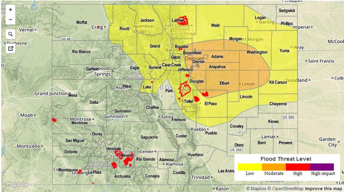
Zone-Specific Forecasts
Urban Corridor and Front Range:
Scattered showers and thunderstorms will begin to develop between 11 AM and Noon; a few will become strong-to-severe over the Urban Corridor shortly thereafter. The threat of strong storms will remain until 8-9 PM, with general showers and thunderstorms then continuing into tomorrow morning.
Maximum rain rates will be in the 2-2.5 inches per hour range, and this makes flash flooding a distinct threat underneath the strongest storms, especially considering the saturated grounds from the last few days of rain.
Palmer Ridge, Northeast Plains, and Southeast Plains:
Scattered thunderstorms will begin to develop/move overhead in the 11 AM – Noon timeframe, with storms becoming quickly strong-to-severe, across the Palmer Ridge and Southeast Plains first, then over the Northeast Plains. Heavy rain at 2-3 inches/hour, wind gusts up to 60 mph, and hail greater than 1 inch in diameter will be threats under any of the stronger thunderstorms. A tornado or two will be possible, as well, especially early this afternoon when low-level moisture is maximized. Storm motions over the Plains will limit some of the potential for flash flooding, but street and field ponding already exists in some locations due to the last few days of rain.
Southeast Mountains and Raton Ridge:
Isolated-to-scattered showers and thunderstorms will develop between 11 AM and Noon, with the bulk of the activity ending by 6 PM. A few showers/thunderstorms will continue into the night over northern portions of the region. Maximum rain rates will be in the 0.4-0.8 inch/hour range.
Northern Mountains, Central Mountains, and Northwest Slope:
A few showers and thunderstorms are ongoing across the regions, and will increase in coverage with time into this afternoon. Expect most activity to end just after sunset, with a few weak showers over the higher terrain continuing into tomorrow morning. Rain rates will be in the 0.75-1.2 inches/hour range, so a low flash flood threat is in place for portions of these regions.
San Juan Mountains, Southwest Slope, Grand Valley, and San Luis Valley:
A few showers will continue throughout the day, though most activity will be shut off due to subsidence/dry air behind todays shortwave. Any showers will likely stay anchored to the higher terrain, with rain rates less than 0.4 inches/hour.