Issue Date: May 6th, 2015
Issue Time: 10:30 AM MDT
— Low flood threat for Northwest Slope, parts of Northern Mountains and parts of Grand Valley
— Low flood threat for Palmer Divide, Urban Corridor and parts of Northeast Plains
— Low flood threat for South Platte River from Greeley through Fort Morgan
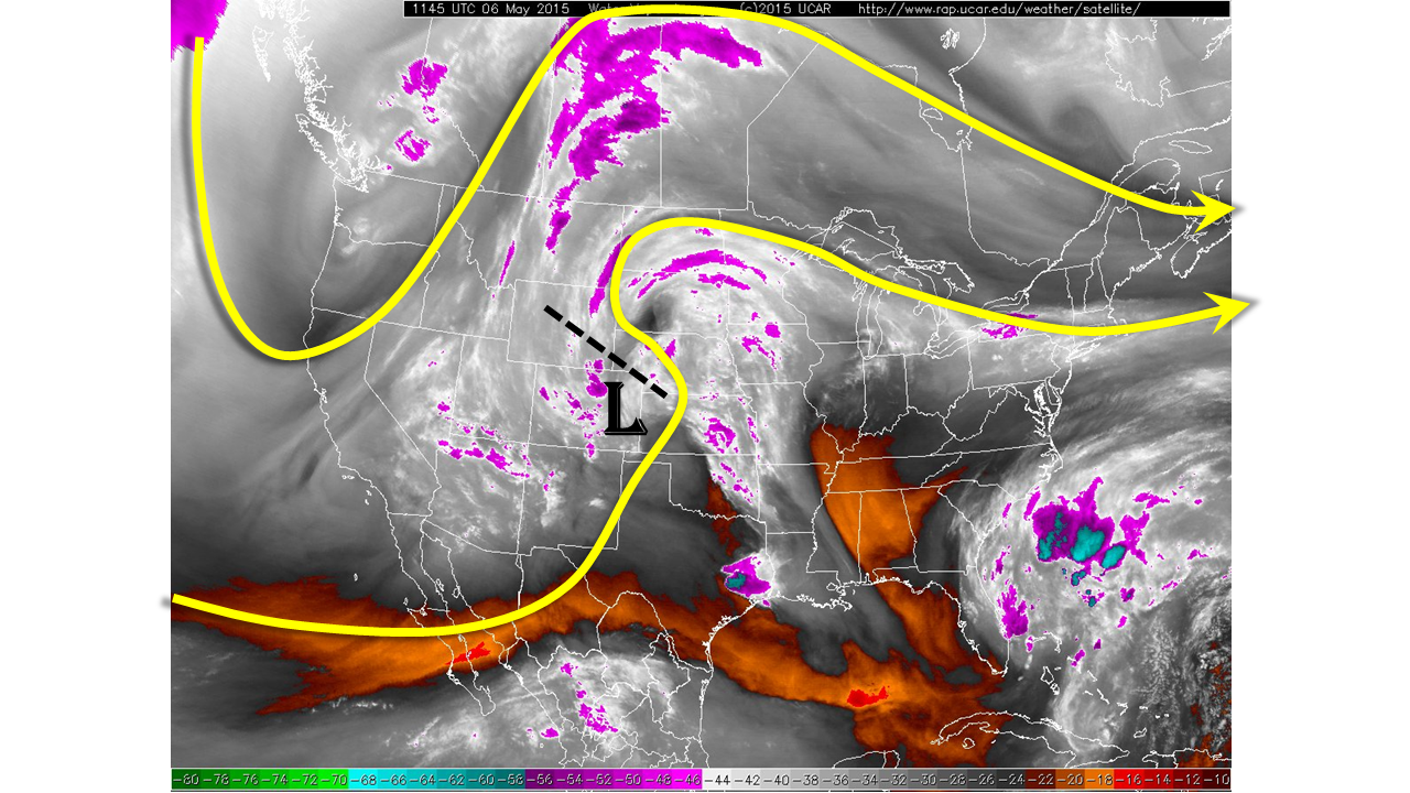
This morning’s weather analysis shows quite an active pattern across western United States. A polar jet is identified over the Pacific Northwest while a subtropical jet continues to pulse and propagate slowly eastward near the United States/Mexico border. As shown in the water vapor image below, the disturbance causing yesterday’s rainfall was just leaving northeast Colorado but radar returns still show light to moderate rain across the Northeast Plains with lighter rainfall in the Southeast Plains and also over the Grand Valley. A weak surface low-pressure system was noted across eastern Colorado and some clearing was seen along the New Mexico border. Precipitable water values continue to run abnormally high for early May with this morning’s values coming in at 0.85 in Pueblo and Grand Junction and 0.7 in Boulder.
There are both similarities and differences between today’s weather setup compared to yesterday’s. The similarity is the upper-level pattern will be generally conducive to upward motion and thus rainfall. On the other hand, the organized disturbance causing yesterday’s rainfall is moving out of the state, leaving less organized support for widespread rain today. Another important difference is that we expect more sunshine today especially the farther south one goes, which will allow for warmer temperatures and significantly more instability. Collectively, our high-resolution precipitation probability product below shows a good estimate of which locations will likely be impacted by rainfall today.
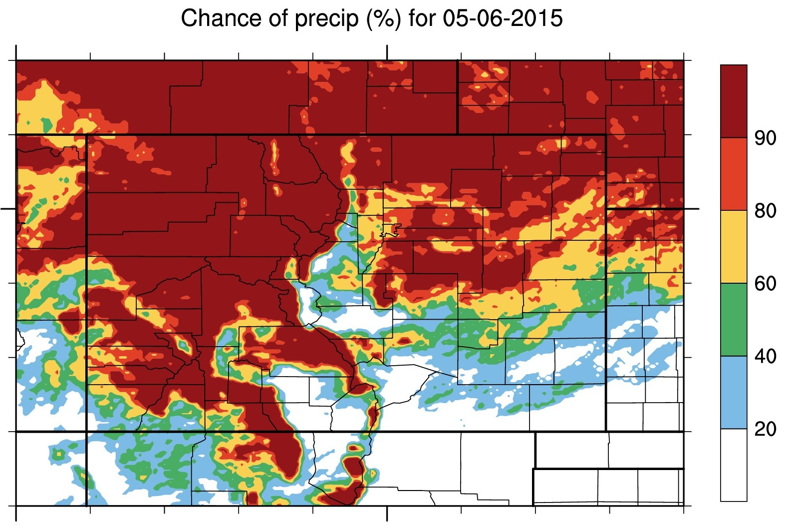
In terms of specifics, expect light to moderate rainfall to continue across the north with breaks in the clouds across the south. Showers and then thunderstorms will increase in coverage with the afternoon heating and affect the entire I-70 corridor east and west of the Divide. Due to yesterday’s rainfall, a low flood threat is once again in place in the Northwest part of the state for debris slides and mud flows. Meanwhile, instability, high moisture content and slow storm motion warrant a low flood threat for parts of northeast Colorado as thunderstorms redevelop in the afternoon. A few storms may become strong with small hail possible. Most rainfall activity will quickly subside shortly after sunset. The South Platte River has become elevated from the past few days of moderate rainfall. A low flood threat has been posted from minor riverside flooding from the Greeley to Fort Morgan stretch of the river.

Zone-Specific Forecasts
Urban Corridor, Front Range, Northeast Plains, Palmer Ridge:
Overcast early with showers slowly shrinking in coverage by noon. Breaks in the sun will boost temperatures and allow for a development of thunderstorm activity by mid-afternoon along the foothills of the entire Urban Corridor. Storms will be capable of producing rainfall up to 1.4 inches per hour. This may result in isolated flash flooding due to saturated soils. A low flood threat has been posted for parts of the area as well as the South Platte River from Greeley to Fort Morgan. Activity will subside shortly after sunset.
Southeast Plains, Raton Ridge and Southeast Mountains:
Early morning showers will dissipate leading to clearing skies. Temperatures will rise and allow for isolated to widely scattered thunderstorm activity mainly in the northern parts of the area. Thunderstorms may produce rain rates up to 1 inch per hour. No flood threat is expected.
Central Mountains, San Juan Mountains, San Luis Valley and Southwest Slope:
Morning cloud cover partially break up leading to some sunshine. Showers and isolated weak thunderstorms may redevelop in the afternoon but rain rates are expected to stay at 0.4 inches per hour or below. No flood threat is expected.
Northwest Slope, Grand Valley, and Northern Mountains:
Morning showers and isolated thunderstorms will continue and likely redevelop in coverage by early afternoon. Rain rates will generally be less than 0.5 inches per hour, however later in the afternoon enough instability may allow for stronger thunderstorms with rain rates up to 0.7 inches per hour. Due to yesterday’s widespread moderate rainfall, a low flood threat has been posted for isolated flash flooding, debris slides and mud flows.