FTB 05-19-2015: Rain/Snow Tapering off from Southwest to Northeast Early, Action Picks Up Again Around Lunchtime

Issue Date: 5/19/2015
Issue Time: 10:36 AM

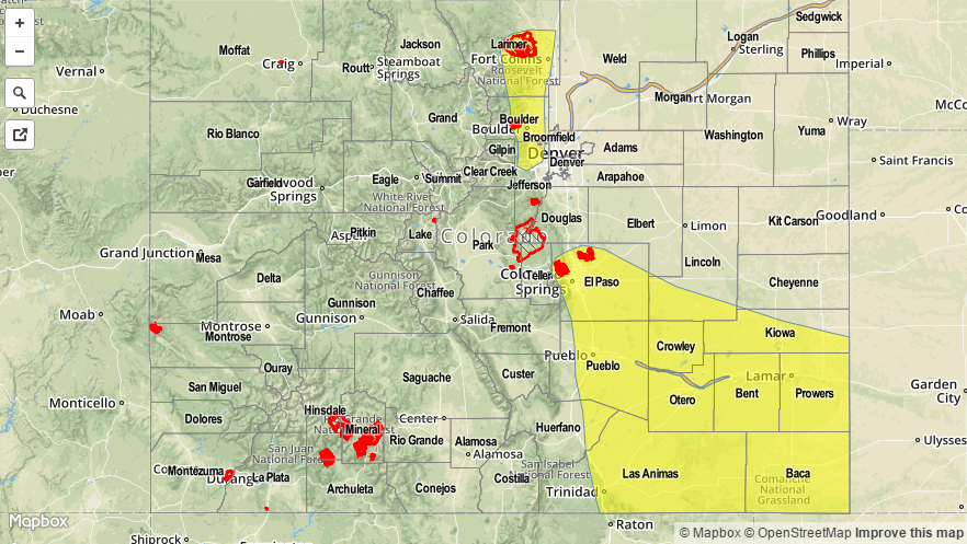
A MODERATE FLOOD THREAT HAS BEEN ISSUED FOR THE CACHE LA POUDRE NEAR GREELEY, SOUTH PLATTE RIVER FROM HENDERSON TO JULESBURG, AND THE ARKANSAS RIVER FROM AVONDALE TO LA JUNTA. A LOW FLOOD THREAT HAS BEEN ISSUED FOR PORTIONS OF THE FRONT RANGE, URBAN CORRIDOR, PALMER RIDGE, RATON RIDGE, AND SOUTHEAST PLAINS.

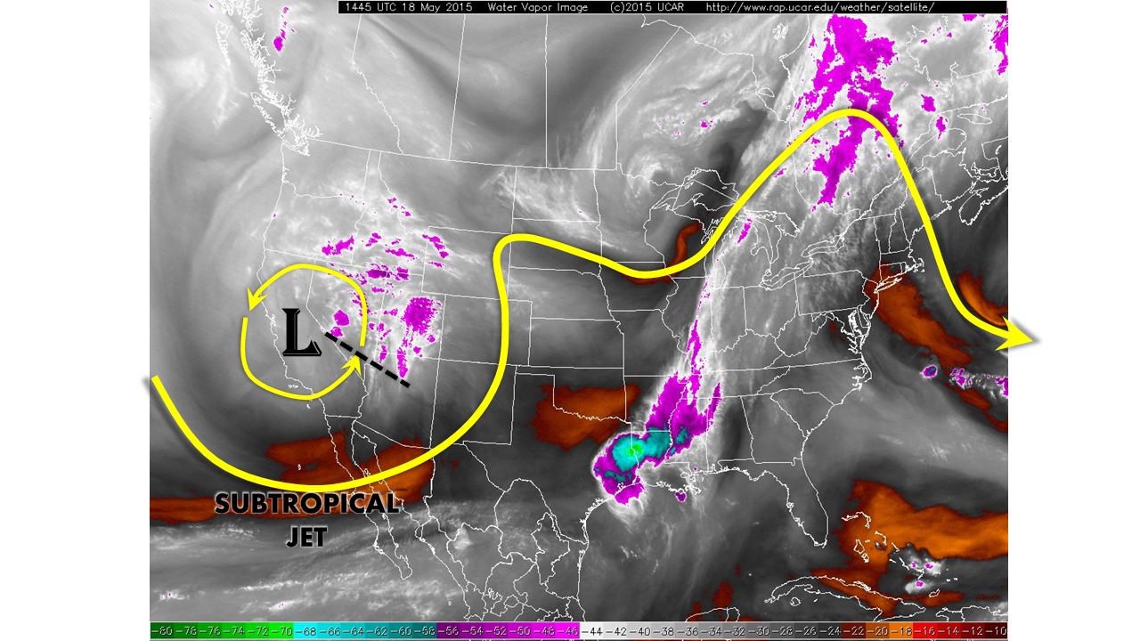
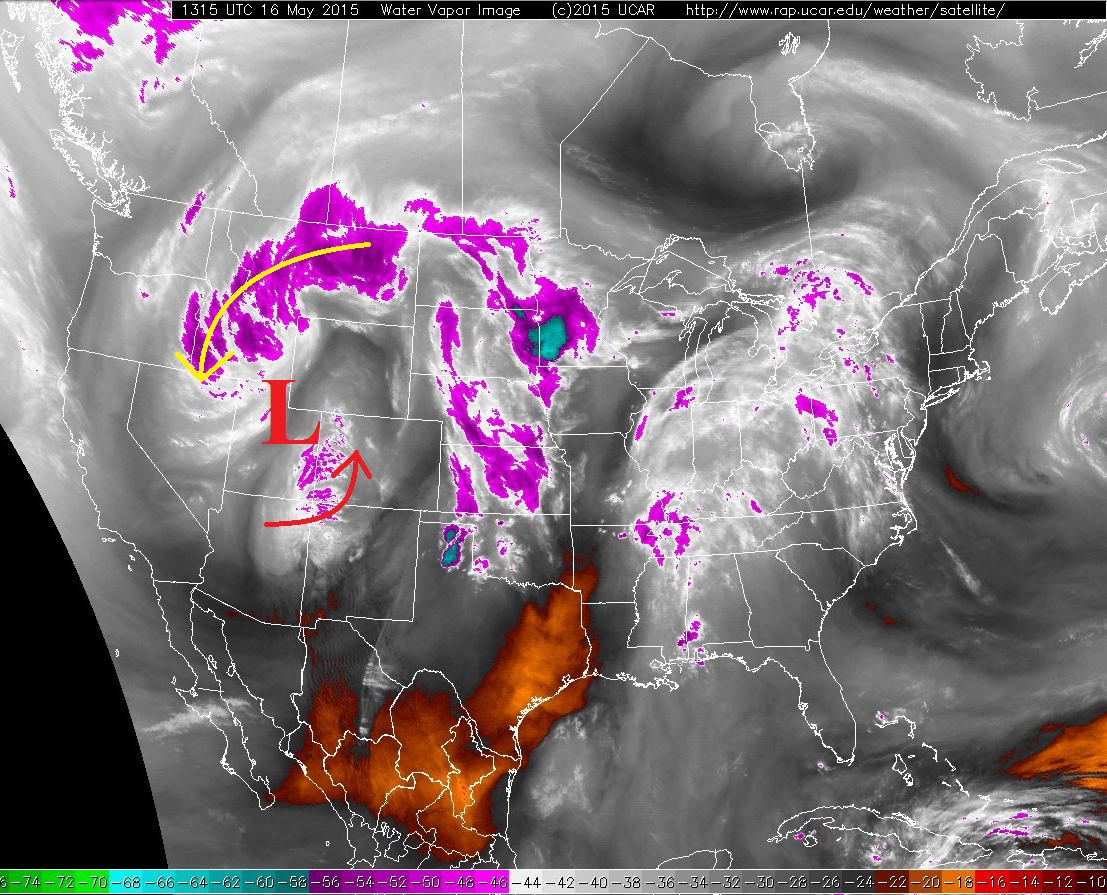
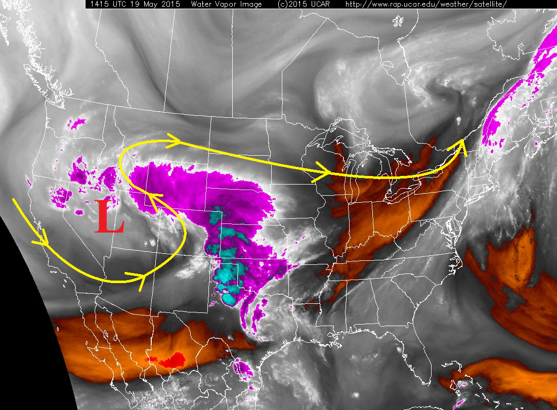
Last night/this morning’s rain and snow continues to taper off from southwest to northeast, bringing the widespread precipitation to an end. Don’t let this break after this morning’s action fool you, because another round of isolated-to-scattered showers and thunderstorms are in store (again). This new round of action will start around lunchtime as another disturbance rotates around the upper-level low (marked by the red “L” in the water vapor imagery below). Due to the cool air in place, thanks in large part to this morning’s rain, widespread heavy rain is not expected. Instead, most rain rates will generally be light, in the 0.25-0.5 inch/hour range. However, a few stronger storms will develop over southern portions of the Urban Corridor, Palmer Ridge, Southeast Plains, and Raton Ridge, producing rain rates in the 0.5-1.2 inches/hour range. For this reason, and the amount of rain received this morning, those locations have been put under a low flood threat for this forecast period.

WV_05192015

Over the higher country, snow levels will be around 10,000 feet, with lower elevations receiving rain. Isolated-to-widely scattered showers are expected to increase in coverage around 11 AM, and last throughout most of the day, before diminishing after sunset. A few showers will linger over the Northwest Slope, Northern Mountains, and northern portions of the Front Range until midnight. Mid-level ridging will begin to build in overnight, meaning a more peaceful nighttime is in store across the state.

Today’s Flood Threat Map

For more information on today’s flood threat, see the map below (hover over threat areas for more details). For Zone-Specific forecasts, jump below the map.

20150519_MFT
Flood Threat Legend

Zone-Specific Forecasts

Urban Corridor (south of Castle Rock), Palmer Ridge, Raton Ridge, and Southeast Plains:

This morning’s rain continues to taper off/push to the north-northeast, but the next round of isolated-to-scattered showers and thunderstorms will begin to develop between 11 AM and Noon. The strongest storms will produce rain rates of 0.5-1.2 inches/hour, but most rainfall will be in the 0.25-0.5 inches/hour range. The likeliest location for strong thunderstorms will be over the Raton Ridge and Southeast Plains, but moderate-to-heavy rain cannot be ruled out for the Urban Corridor and Palmer Ridge due to upslope surface winds.

Timing: 11 AM – 9 PM

Urban Corridor (north of, and including, Castle Rock), Front Range and Northeast Plains:

The precipitation shield currently across the region continues to push northward and out of the state, but a few showers continue to persist across Boulder, northern Jefferson, and Larimer Counties thanks to upslope surface flow. For this reason, a low a flood threat has been issued for portions of the Urban Corridor and Front Range where this upslope precipitation is occurring and will continue through the early afternoon.

The next round of isolated-to-widely scattered showers will begin to develop between 11 AM and Noon behind the exiting precipitation shield. Maximum rain rates will be in the 0.2-0.45 inch/hour range. Activity will diminish quickly after sunset.

Northern Mountains, Northwest Slope, Grand Valley, Central Mountains, San Juan Mountains, Southeast Mountains, San Luis Valley, and Southwest Slope:

Isolated-to-widely scattered showers are ongoing across the region, mainly over the higher terrain. An uptick in activity will occur between 11 AM and Noon, developing over the higher elevations and then drifting over valleys with time. Snow levels will be around 10,000 feet, with rain occurring below 10,000 feet. Rain rates will generally be light, in the 0.2-0.4 inches/hour range. Activity will diminish quickly after sunset, with only a few light rain/snow showers continuing over higher terrain in northern areas until midnight.

FTB 05-18-2015: Another Disturbance Teams Up With Cool Front To Provide Overnight Heavy Rain Threat

Issue Date: 5/18/2015
Issue Time: 10:50 AM

— LOW flood threat for Southeast Mountains, Southeast Plains and parts of Palmer Ridge for overnight hours

Another cut-off low pressure disturbance will combine with strong subtropical jet dynamics to provide more cloudiness, showers and thunderstorms over parts of Colorado. These features are well depicted in the water vapor image below. For most of today, we expect on and off showers and isolated, weak thunderstorms to be seen across most of the state. The passage of a morning cool front will limit atmospheric instability and prevent stronger storms and/or heavier rainfall. No flooding is expected through the day and into the evening.

watervapor_20150518

Things turn interesting later in the evening and into the overnight hours as the disturbance approaches Colorado. Almost all guidance suggests that strong moisture transport from Texas and Mexico will likely develop storms capable of producing heavy rainfall over the Southeast Plains. The map below shows the forecasted wind speed about 6,000 feet above the ground at 3 AM. Note values exceeding 50 knots (~55 mph) over eastern Colorado. Additionally, Precipitable Water values are forecasted to increase from 0.6 inches this morning to over 1 inch in the Southeast Plains after midnight. Thus, a Low flood threat has been issued over parts of Southeast Colorado for isolated flash flooding from heavy rainfall.

700mb_windspeed

Please see below for area-specific flood threat and forecasts (click on “About the FTB” link above to view Colorado region names).

Flood Threat Legend


Zone-Specific Forecasts

Urban Corridor, Front Range, Northeast Plains:

Scattered showers continuing throughout the day and into the evening. Rainfall rates will generally be in the 0.2-0.4 inch per hour range. Flooding is not expected today.

Palmer Ridge, Raton Ridge and Southeast Plains:

Scattered showers developing by early afternoon. Rainfall rates will be in the 0.2-0.5 inch per hour range. Later in the evening and into the overnight hours, thunderstorms are expected to develop as a surge of moisture moves northeastward. These storms will be capable of producing 2 inch per hour rainfall, and hail up to 0.75 inches. A Low flood threat has been issued for the overnight hours for most of the area.

Central Mountains, San Juan Mountains, Southeast Mountains and Northern Mountains:

Rain and snow showers developing throughout the day, and increasing in coverage as a disturbance approaches from the west. Hourly rainfall rates will be in the 0.2-0.4 inch range. No flooding is expected. An additional 3-6 inches of snowfall will be possible in the highest elevations, above 11,000 feet.

Southwest Slope, Northwest Slope, Grand Valley and San Luis Valley:

Sunny early, with clouds increasing during the late morning. Showers will develop across many areas by early afternoon and persist into the evening and early overnight hours. Rainfall rates will be in the 0.2 to 0.4 inch per hour range. An isolated weak thunderstorm is possible in the afternoon. No flooding is expected.

FTB 05-17-2015: Shortwave Ridging Leading to a Quieter Day

Issue Date: 5/17/2015 Issue Time: 9:40 AM NO FLOOD THREAT IS FORECAST. Today will be a break in the larger pattern of unsettled weather that has more or less continued since the beginning of May. The water vapor imagery below depicts the situation well, as the upper-level low continues to slide east. The red arrow depicts the NW flow around the backside of that low, which has an embedded pocket of moisture allowing for the morning showers ongoing across the high country. For our forecast period, beginning at 11 AM, the feature of note is the shortwave ridge, represented by the black line. 05172015_WV This shortwave ridge will make showers and thunderstorms hard to come by this afternoon and evening, save for a bit of weak instability over the plains and orographic forcing from the mountains. The short of it all is that this afternoon and evening will feature isolated-to-widely scattered showers and weak thunderstorms, mainly over the higher terrain of the Northwest Slope, Northern Mountains, Front Range, Central Mountains, and San Juan Mountains. For the Urban Corridor, Palmer Ridge, and Northeast Plains, showers/weak thunderstorms will be isolated, producing mainly gusty outflow winds and light rain. Not much, if any, activity is expected over the Southeast Plains and Raton Ridge. For the remaining regions (Southeast Mountains, San Luis Valley, Grand Valley, and Southwest Slope), isolated showers/weak thunderstorms will occur over the higher terrain, weakening quickly as they move over lower elevations. Expect most activity statewide to end just after sunset, with a few showers lingering until midnight.

Today’s Flood Threat Map

For more information on today’s flood threat, see the map below (hover over threat areas for more details). For Zone-Specific forecasts, jump below the map. NoFloodThreat

Zone-Specific Forecasts

Urban Corridor, Palmer Ridge and Northeast Plains:

Isolated weak showers and thunderstorms this afternoon and evening, otherwise mostly sunny. Rain rates will be light, as any activity will produce more gusty winds than rain. Maximum rain rates will be 0.25-0.4 inches/hour. Timing: Noon – 9 PM, with a few showers lingering over the Northeast Plains until midnight.

Raton Ridge and Southeast Plains:

One or two isolated showers/weak thunderstorms, but the real story of the day will be mostly sunny skies and warmth. Rain rates from any activity will be less than 0.2 inches/hour. Timing: 2 PM – 9 PM

Southeast Mountains, San Luis Valley, Grand Valley, and Southwest Slope:

Isolated showers/weak thunderstorms will occur this afternoon and evening over the higher terrain, and will diminish quickly after moving over lower elevations. Rain rates will be less than 0.25 inches/hour. Timing: Noon – 9 PM

Northern Mountains, Central Mountains, Front Range, San Juan Mountains, and Northwest Slope:

Isolated-to-widely scattered showers and weak thunderstorms, mainly over the higher elevations. Storms will move over valleys/lower elevations, and diminish quickly with the loss of orographic support. Northern regions will be favored, because they will be nearest the mid-/upper-level moisture plume. Maximum rain rates will be in the 0.25-0.45 inches/hour range. Timing: 11 AM – 9 PM, with one or two showers lingering until midnight.

FTB 05-16-2015: Upper-Level Low Continues to Slide East

Issue Date: 5/16/2015
Issue Time: 9:30 AM

NO FLOOD THREAT IS FORECAST FOR TODAY. HOWEVER, STREET PONDING IS POSSIBLE ACROSS THE URBAN CORRIDOR BETWEEN I-70 AND JUST SOUTH OF CASTLE ROCK DUE TO WEAK STEERING WINDS IN THIS OUTLINED AREA.

The upper-level low that we discussed yesterday is on the move again today, moving eastward from its current position over Utah. This will allow for two “waves” of precipitation today; the first as showers and thunderstorms (with snow above 9000 feet), the second will be overnight snow showers over the mountains. These two distinct “waves” show up well in the water vapor imagery, with the red arrow marking today’s disturbance, and the yellow arrow marking tonight’s disturbance.

05162015_WV

Precipitable water values are on the low-side of normal for this time of year, so expect most rainfall to be of the light-to-moderate variety, with the best chance of heavy rain near the CO/KS border. For these reasons, no flood threat is being issued today. With that said, as outlined in the header text above, street ponding is possible across the Urban Corridor between I-70 and just south of Castle Rock due to weak steering winds/storm motion. Another 3-6 inches of snow accumulations are likely above 9000 feet across the San Juan Mountains and Central Mountains, with lighter accumulations for other mountains through the overnight hours.

Today’s Flood Threat Map

For more information on today’s flood threat, see the map below (hover over threat areas for more details). For Zone-Specific forecasts, jump below the map.

NoFloodThreat
Flood Threat Legend

Zone-Specific Forecasts

Front Range, Urban Corridor, Palmer Ridge, Northeast Plains, Raton Ridge, and Southeast Plains:

Isolated-to-scattered showers and thunderstorms are expected again today, beginning between 11 AM and Noon, and diminishing after sunset. A few isolated thunderstorms will be ongoing across the Northeast Plains until Midnight before exiting the state to the east.

Maximum rain rates will be in the 0.7-1.0 inch/hour range for much of the area, with stronger storms near the CO/KS border producing maximum rain rates of 1.0-1.4 inches/hour. Douglas, Elbert, southern Denver, and Arapahoe Counties will be a focus region for potential of stronger thunderstorm development this afternoon, which will hold the ability to produce maximum rain rates of 0.9-1.4 inches/hour. However, the realized rain rates will likely be closer to 0.75-1.0 inches/hour. This is the reason for the highlight of street flooding mentioned in the discussion above, but no flood threat being issued. Likely rain rates will be below flash flood thresholds, but a slow storm motion can cause drainage issues, especially in low-lying intersections and normal trouble spots.

Southeast Mountains:

Scattered showers and thunderstorms are expected today, beginning 10 AM-Noon, and diminishing by sunset as mid-level flow becomes more northwesterly and daytime heating ends. Maximum rain rates will be in the 0.2-0.45 inches/hour range.

Northern Mountains, Central Mountains, San Juan Mountains, Northwest Slope, Southwest Slope, Grand Valley, and San Luis Valley:

Much like yesterday, locations above 9000 feet can expect scattered snow showers today, with lower elevations experiencing scattered showers and thunderstorms this today and this evening (Now – 9 PM). Central and Southern regions will be favored for the most coverage of showers and storms during this time period. Maximum rain rates will be 0.2-0.4 inches/hour.

Overnight, as the second disturbance moves across the area, northerly flow will bring isolated-to-scattered snow showers to higher elevations thanks to orographic lift. Central and Northern regions will be favored for this overnight activity (10 PM – 8 AM).