Issue Date: 5/17/2015 Issue Time: 9:40 AM NO FLOOD THREAT IS FORECAST. Today will be a break in the larger pattern of unsettled weather that has more or less continued since the beginning of May. The water vapor imagery below depicts the situation well, as the upper-level low continues to slide east. The red arrow depicts the NW flow around the backside of that low, which has an embedded pocket of moisture allowing for the morning showers ongoing across the high country. For our forecast period, beginning at 11 AM, the feature of note is the shortwave ridge, represented by the black line. 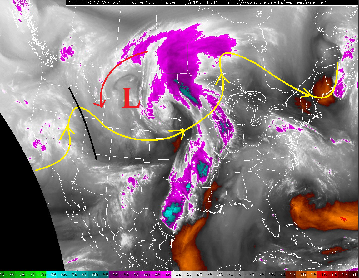 This shortwave ridge will make showers and thunderstorms hard to come by this afternoon and evening, save for a bit of weak instability over the plains and orographic forcing from the mountains. The short of it all is that this afternoon and evening will feature isolated-to-widely scattered showers and weak thunderstorms, mainly over the higher terrain of the Northwest Slope, Northern Mountains, Front Range, Central Mountains, and San Juan Mountains. For the Urban Corridor, Palmer Ridge, and Northeast Plains, showers/weak thunderstorms will be isolated, producing mainly gusty outflow winds and light rain. Not much, if any, activity is expected over the Southeast Plains and Raton Ridge. For the remaining regions (Southeast Mountains, San Luis Valley, Grand Valley, and Southwest Slope), isolated showers/weak thunderstorms will occur over the higher terrain, weakening quickly as they move over lower elevations. Expect most activity statewide to end just after sunset, with a few showers lingering until midnight.
Today’s Flood Threat Map
For more information on today’s flood threat, see the map below (hover over threat areas for more details). For Zone-Specific forecasts, jump below the map. 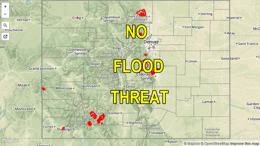
Zone-Specific Forecasts
Urban Corridor, Palmer Ridge and Northeast Plains:
Isolated weak showers and thunderstorms this afternoon and evening, otherwise mostly sunny. Rain rates will be light, as any activity will produce more gusty winds than rain. Maximum rain rates will be 0.25-0.4 inches/hour. Timing: Noon – 9 PM, with a few showers lingering over the Northeast Plains until midnight.
Raton Ridge and Southeast Plains:
One or two isolated showers/weak thunderstorms, but the real story of the day will be mostly sunny skies and warmth. Rain rates from any activity will be less than 0.2 inches/hour. Timing: 2 PM – 9 PM
Southeast Mountains, San Luis Valley, Grand Valley, and Southwest Slope:
Isolated showers/weak thunderstorms will occur this afternoon and evening over the higher terrain, and will diminish quickly after moving over lower elevations. Rain rates will be less than 0.25 inches/hour. Timing: Noon – 9 PM
Northern Mountains, Central Mountains, Front Range, San Juan Mountains, and Northwest Slope:
Isolated-to-widely scattered showers and weak thunderstorms, mainly over the higher elevations. Storms will move over valleys/lower elevations, and diminish quickly with the loss of orographic support. Northern regions will be favored, because they will be nearest the mid-/upper-level moisture plume. Maximum rain rates will be in the 0.25-0.45 inches/hour range. Timing: 11 AM – 9 PM, with one or two showers lingering until midnight.