Issue Date: 5/16/2015
Issue Time: 9:30 AM
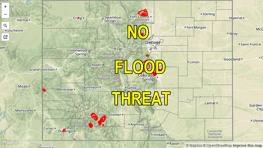
NO FLOOD THREAT IS FORECAST FOR TODAY. HOWEVER, STREET PONDING IS POSSIBLE ACROSS THE URBAN CORRIDOR BETWEEN I-70 AND JUST SOUTH OF CASTLE ROCK DUE TO WEAK STEERING WINDS IN THIS OUTLINED AREA.
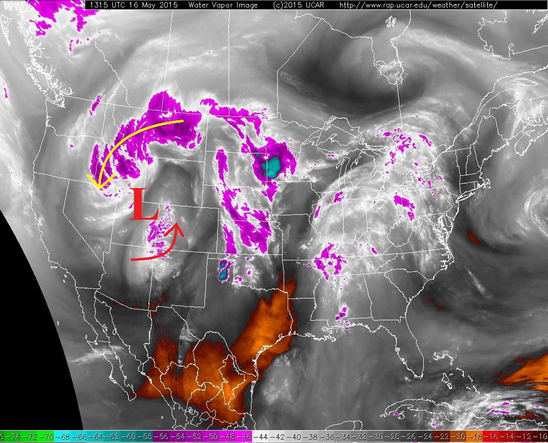
The upper-level low that we discussed yesterday is on the move again today, moving eastward from its current position over Utah. This will allow for two “waves” of precipitation today; the first as showers and thunderstorms (with snow above 9000 feet), the second will be overnight snow showers over the mountains. These two distinct “waves” show up well in the water vapor imagery, with the red arrow marking today’s disturbance, and the yellow arrow marking tonight’s disturbance.
Precipitable water values are on the low-side of normal for this time of year, so expect most rainfall to be of the light-to-moderate variety, with the best chance of heavy rain near the CO/KS border. For these reasons, no flood threat is being issued today. With that said, as outlined in the header text above, street ponding is possible across the Urban Corridor between I-70 and just south of Castle Rock due to weak steering winds/storm motion. Another 3-6 inches of snow accumulations are likely above 9000 feet across the San Juan Mountains and Central Mountains, with lighter accumulations for other mountains through the overnight hours.
Today’s Flood Threat Map
For more information on today’s flood threat, see the map below (hover over threat areas for more details). For Zone-Specific forecasts, jump below the map.

Zone-Specific Forecasts
Front Range, Urban Corridor, Palmer Ridge, Northeast Plains, Raton Ridge, and Southeast Plains:
Isolated-to-scattered showers and thunderstorms are expected again today, beginning between 11 AM and Noon, and diminishing after sunset. A few isolated thunderstorms will be ongoing across the Northeast Plains until Midnight before exiting the state to the east.
Maximum rain rates will be in the 0.7-1.0 inch/hour range for much of the area, with stronger storms near the CO/KS border producing maximum rain rates of 1.0-1.4 inches/hour. Douglas, Elbert, southern Denver, and Arapahoe Counties will be a focus region for potential of stronger thunderstorm development this afternoon, which will hold the ability to produce maximum rain rates of 0.9-1.4 inches/hour. However, the realized rain rates will likely be closer to 0.75-1.0 inches/hour. This is the reason for the highlight of street flooding mentioned in the discussion above, but no flood threat being issued. Likely rain rates will be below flash flood thresholds, but a slow storm motion can cause drainage issues, especially in low-lying intersections and normal trouble spots.
Southeast Mountains:
Scattered showers and thunderstorms are expected today, beginning 10 AM-Noon, and diminishing by sunset as mid-level flow becomes more northwesterly and daytime heating ends. Maximum rain rates will be in the 0.2-0.45 inches/hour range.
Northern Mountains, Central Mountains, San Juan Mountains, Northwest Slope, Southwest Slope, Grand Valley, and San Luis Valley:
Much like yesterday, locations above 9000 feet can expect scattered snow showers today, with lower elevations experiencing scattered showers and thunderstorms this today and this evening (Now – 9 PM). Central and Southern regions will be favored for the most coverage of showers and storms during this time period. Maximum rain rates will be 0.2-0.4 inches/hour.
Overnight, as the second disturbance moves across the area, northerly flow will bring isolated-to-scattered snow showers to higher elevations thanks to orographic lift. Central and Northern regions will be favored for this overnight activity (10 PM – 8 AM).