ISSUE DATE: May 23, 2015
ISSUE TIME: 10:40AM
— MODERATE flood threat for South Platte River from Greeley through the Nebraska state line
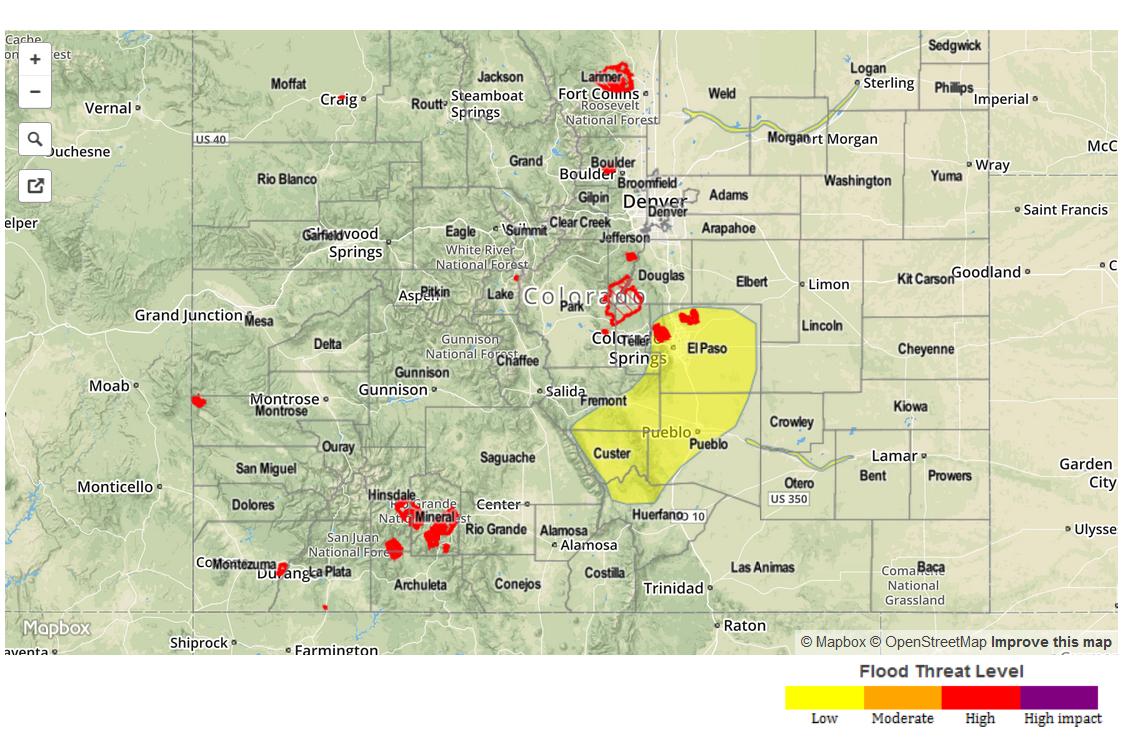
— MODERATE flood threat for Front Range (likely to continue through tomorrow)
— MODERATE flood threat for Northeast Plains
— LOW flood threat for Northeast Plains and parts of Urban Corridor and Front Range
— LOW flood threat for Arkansas River from Pueblo through La Junta
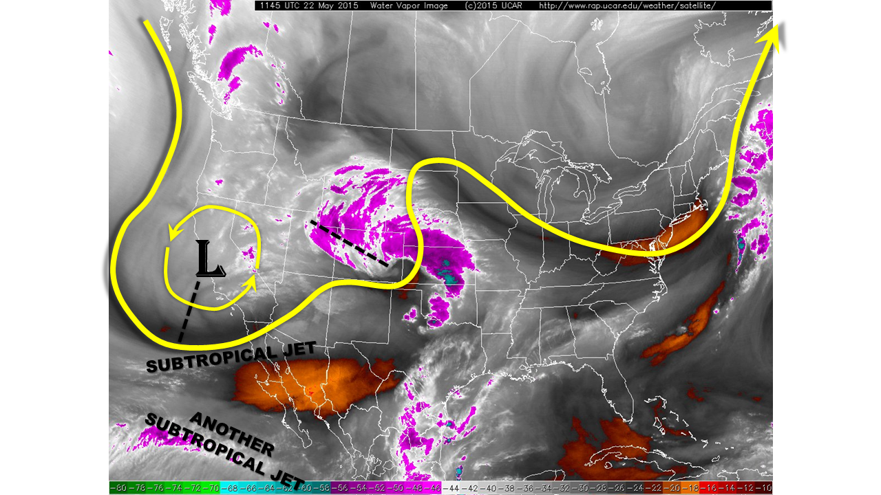
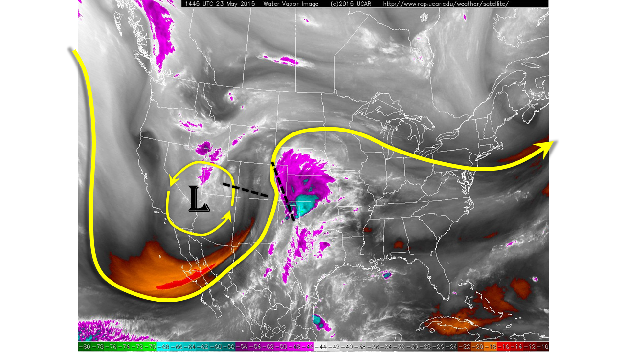
The cut-off low that was over California yesterday is approaching the Four Corners this morning, as shown by the water vapor image below. Two distinct disturbances are noted to its east: one that barely grazes Colorado and is mainly responsible for clouds over the state, and another that is positioned on the Colorado/New Mexico border. It is the latter that will deliver most of the weather impact to day across our state.
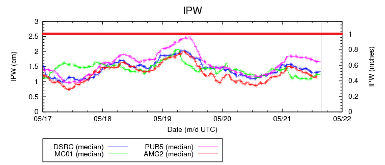
This morning, sunshine is more abundant across the state and temperatures have quickly responded, running several degrees above yesterday’s readings east of the Divide. Dewpoint temperatures are in the 40s to low 50s across most of the state. Meanwhile, precipitable water values are only 0.4 inches at Grand Junction, but close to 0.8 at Pueblo. This indicates that the upper atmosphere is somewhat drier today compared to yesterday especially west of the Divide. However, the strong dynamics of the incoming system will be enough to overcome this.
For today, we expect showers and thunderstorms to quickly dot a large portion of the state. Initially, rainfall across most areas will be light. However, as the afternoon heating progresses and good convergence occurs along the higher terrain, heavier rainfall is expected across the Front Range and perhaps spilling over into the Northern and Central Mountains. Storm motion will be fast, at 30-40 mph, but multiple storms may affect the same area. For this reason, in concert with it being Memorial Day weekend with many hikers and campers around, a Moderate flood threat is in place for the Front Range for afternoon and evening storms. This threat will likely persist through tomorrow as the upper-low moves directly overhead.
Farther east, another round of strong to severe thunderstorms is expected across the Palmer Ridge and Northeast Plains. One hour rainfall up to 1.7 inches and 3 hour rainfall up to 3 inches warrants a Moderate flood threat for parts of the area. Saturated soils are a contributing factor.
We have raised the South Platte River flood threat from Low to Moderate in anticipation of substantial afternoon and evening runoff. The Arkansas River is under a Low flood threat from Pueblo to La Junta.
We urge anyone with outdoor activities to stay current with today’s weather evolution. An excellent source of real-time information is the National Weather Service.
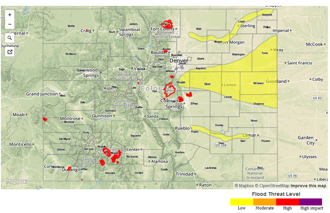
Today’s Flood Threat Map
For more information on today’s flood threat, see the map below (hover over threat areas for more details). For Zone-Specific forecasts, jump below the map.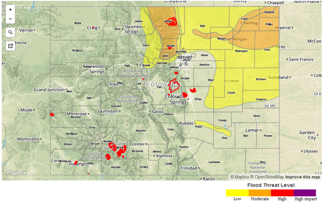
Zone-Specific Forecasts
Front Range, Northern Mountains and Central Mountains:
Partly cloudy skies with numerous rounds of shower and thunderstorm activity developing by early afternoon. One hour rainfall up to 1.25 inch and 3-hr rainfall up to 2.5 inches will lead to localized flash flooding, debris slides and mud flows. A Moderate flood threat is in place for the Front Range with a Low flood threat elsewhere
Prime time: From 2pm through the overnight hours
Urban Corridor, Northeast Plains and Palmer Ridge:
Partly cloudy skies with showers and thunderstorms developing by early afternoon. One hour rainfall up to 1.7 inches and 3-hour rainfall up to 3 inches will be possible near the Kansas border with lower amounts elsewhere. Severe weather, including large hail up to 1.5 inches, damaging winds up to 75 mph and a weak tornado are all possible. A Moderate flood threat is in place in the far northeast with a Low flood threat elsewhere. Formation of the Denver cyclone will likely limit rainfall amounts in the immediate Denver metro area.
Prime time: 2pm through 10pm
Southeast Mountains, Raton Ridge and Southeast Plains:
Mostly sunny to partly cloudy with scattered storms developing by early afternoon. One hour rainfall up to 1 inch is possible, but a pocket of dry air aloft and fast storm motion is expected to limit the flood threat.
Prime time: 2pm through 7pm
Southwest Slope, Northwest Slope, Grand Valley, San Juan Mountains and San Luis Valley:
Partly cloudy skies with scattered showers and storms developing. Weak instability will limit one-hour rainfall to 0.6 inches so no flood threat is expected. Small hail, up to 0.5 inches, and gusty winds are possible in the stronger thunderstorms.