Issue Date: 5/20/2015
Issue Time: 10:01 AM
A LOW FLOOD THREAT HAS BEEN ISSUED FOR THE CACHE LA POUDRE/SOUTH PLATTE RIVER FROM GREELEY TO JULESBURG, AND THE ARKANSAS RIVER FROM AVONDALE TO LA JUNTA.
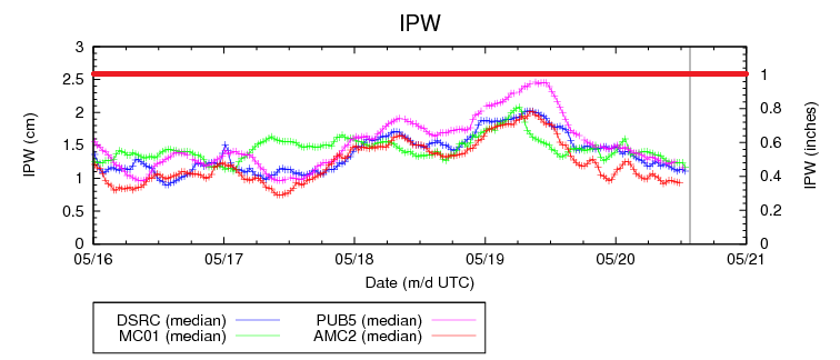
Colorado will experience a downtick in precipitation today, thanks to declining moisture, an unseasonably cool air mass, and a lack of upper-level forcing. The precipitable water (IPW) graph below shows just how much the moisture has declined since Monday afternoon/Tuesday morning. With all of the normal 4 reporting stations reporting IPW values below 0.5 inches, the chance of heavy rain with any isolated shower/thunderstorm is basically zero.
The cool air mass will go a long ways in keeping the plains mostly dry today, especially as one gets further away from the mountains and Palmer Ridge. Additionally, upslope flow will keep clouds socked in across the Urban Corridor, keeping temperatures from recovering to more seasonable temperatures. Expect highs across the Urban Corridor in the upper 40s/low 50s; downright chilly for this time of year.
The best chances for isolated-to-scattered shower and weak thunderstorm activity will be across the higher terrain. Weak steering winds mean that any activity will struggle to move over the valleys, so today’s action will be confined to mainly the higher peaks. A few isolated showers will work over the Urban Corridor and Palmer Ridge this afternoon, but don’t expect much to come from them as rain rates will be less than 0.25 inches/hour.
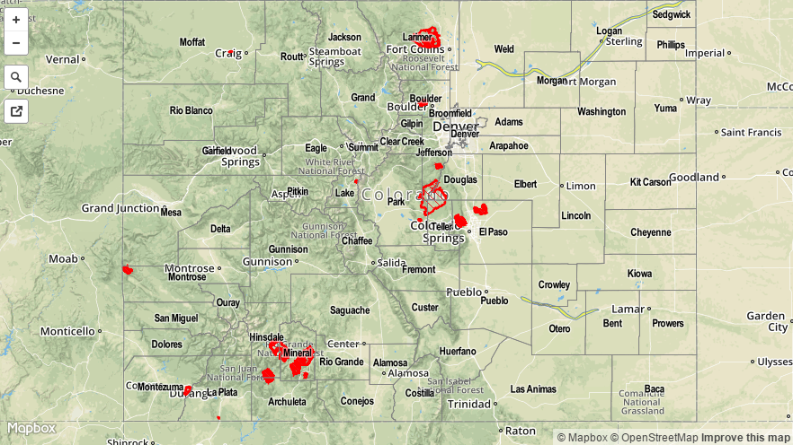
Today’s Flood Threat Map
For more information on today’s flood threat, see the map below (hover over threat areas for more details). For Zone-Specific forecasts, jump below the map.

Zone-Specific Forecasts
Urban Corridor, Palmer Ridge, Raton Ridge, Southeast Plains, and Northeast Plains:
With a cool, stable air mass in place, today will be much quieter across these regions. Most locations will stay underneath mostly cloudy skies, but a few peaks of sun will allow the Southeast Plains and Raton Ridge to warm up into the upper 50s/low 60s. Otherwise, everyone else will be in the upper 40s/low 50s.
A few isolated showers/weak thunderstorms cannot be ruled out over the Urban Corridor, Palmer Ridge, or Raton Ridge this afternoon and evening, but they will not amount to much. Rain rates will be less than 0.25 inches/hour.
Timing: 2 PM – 9 PM
Front Range, Northern Mountains, Northwest Slope, Grand Valley, Central Mountains, San Juan Mountains, Southeast Mountains, San Luis Valley, and Southwest Slope:
The higher elevations will hold the best chance at isolated-to-widely scattered showers and thunderstorms this afternoon and evening. Weak steering winds will keep most, if not all, activity confined to the higher terrain, so chances of precipitation in valleys are very low. Rain rates will mainly be in the 0.1-0.3 inches/hour range, with the maximum rates from the strongest thunderstorms in the 0.25-0.45 inches/hour range.
Timing: 11 AM – 8 PM, with a few isolated showers lingering until 10 PM.