Issue Date: 5/21/2015
Issue Time: 10:45 AM
A LOW FLOOD THREAT HAS BEEN ISSUED FOR PORTIONS OF THE PALMER RIDGE, URBAN CORRIDOR, SOUTHEAST PLAINS, AND SOUTHEAST MOUNTAINS. A LOW FLOOD THREAT CONTINUES FOR PORTIONS OF THE CACHE LA POUDRE/SOUTH PLATTE RIVER, AND PORTIONS OF THE ARKANSAS RIVER.
Today will see an uptick in the coverage and relative intensity of showers and thunderstorms as an upper-level low over California ejects a disturbance across Colorado. Accompanying this disturbance will be an increase in both broad-scale ascent and mid-level moisture, providing the ingredients for the increase in showers/thunderstorms.
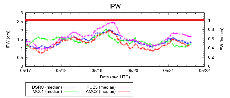
Widespread heavy rain is not expected as instability and deep moisture will still be relatively limited, especially over areas east of the mountains. The IPW graph below shows the moisture picture well; all four of the normal reporting stations are below 0.65 inches, and for a typical heavy rain day those values need to be closer to, or above, an inch. Most rain rates today will be in the 0.3-0.6 inches/hour range, with the best chance at heavy rain occurring across the low flood threat areas. Max rain rates in the low flood threat area will be between 0.7-1.2 inches/hour; combine this with the moist antecedent conditions and there is enough concern to warrant a low flood threat. Additionally, snow levels will be between 9,000 and 10,000 feet today, so higher mountain passes and mountain peaks in the Central Mountains and San Juan Mountains regions will pick up an additional 4-8 inches of snow today/tonight.
Today’s Flood Threat Map
For more information on today’s flood threat, see the map below (hover over threat areas for more details). For Zone-Specific forecasts, jump below the map.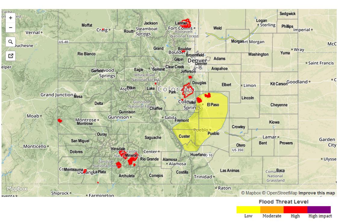
Zone-Specific Forecasts
Urban Corridor (south of Castle Rock), Palmer Ridge, Raton Ridge, Southeast Plains, and Northeast Plains:
For these regions, the counties with the relative greatest risk for moderate-to-heavy rain include El Paso, northwest Pueblo, southern Fremont, Custer, and northwest Huerfano Counties. Max rain rates across these locations (below 9,500 feet) will be in the 0.7-1.2 inches/range, and combined with the moist antecedent conditions, a low flood threat is warranted.
Elsewhere across the regions, any isolated-to-scattered showers/thunderstorms will be relatively weak, producing rain rates in the 0.25-0.5 inches/hour range at best.
Timing: 2 PM – Midnight, with a few light showers continuing into the early morning. A few thunderstorms are expected near the CO/KS border after midnight.
Urban Corridor (along and north of Castle Rock) and Northeast Plains:
A few isolated, showers/weak thunderstorms are expected this afternoon, continuing through the nighttime hours. Near the CO/KS border, a few thunderstorms are expected after midnight tonight as the energy associated with the disturbance crosses the area. Rain rates will typically be in the 0.25-0.5 inches/hour range.
Timing: 3 PM – Midnight, a few showers lingering into the early morning, and a few thunderstorms after midnight near the CO/KS border.
Front Range, Northern Mountains and Northwest Slope:
Isolated-to-scattered showers and weak thunderstorms expected today, diminishing after sunset. Rain rates will maximized at 0.25-0.45 inches/hour, and light snow will fall above 10,000 feet. The far southern extent of the Front Range, i.e., far southeastern Teller County is included in the low flood threat for maximum rain rates in the 0.6-1.0 inches/hour range.
Timing: 11 AM – Midnight, with a shower or two continuing over the highest peaks until 3 AM.
Grand Valley, Central Mountains, San Juan Mountains, Southeast Mountains, San Luis Valley, and Southwest Slope:
Scattered showers and thunderstorms are expected, developing over the higher peaks, and drifting slowly to the northeast with time. Snow levels will be between 9,000 and 10,000 feet, with areas above that gathering 4-8 inches of snow accumulations today and tonight. Below snow level, rain rates are expected to be 0.25-0.5 inch/hour range, with a few stronger thunderstorms over the San Juan Mountains/Southwest Slope pushing 0.5-0.7 inches/hour.
Timing: 11 AM – Midnight, with activity diminishing quickly due to subsidence behind the passing disturbance.