FTB 06-06-2022: Widespread Showers & Thunderstorms To Start the Work Week

Issue Date: Monday, June 6th, 2022
Issue Time: 10:50AM MDT

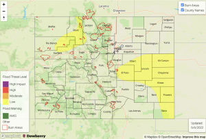
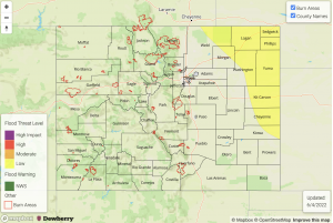
LOW flood threat has been issued for portions of the Northwest Slope, Northern Mountains, southern Urban Corridor, Palmer Ridge, Northeast Plains & Southeast Plains
 Fire-Burn Forecast Summary: 2 burn areas under MODERATE threat, 5 burn areas under LOW threat; click HERE for more info

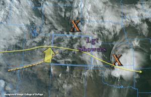
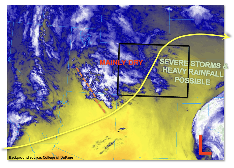
A lot is happening in our synoptic setup today with several ingredients coming together for widespread precipitation this afternoon and into the overnight hours. Marked in the water vapor imagery below is the next shortwave (orange “X”, Montana) and some mid-level energy associated with an incoming jet streak (orange dashed). As the shortwave moves east today, a strong jet streak is also forecast move over the northern tier of the state. Both the right entrance of the jet streak and the additional mid-level energy moving through the flow should help spark numerous rounds of widespread showers and thunderstorms over the mountains and elevated ridges early this afternoon. Increasing westerly steering flows are expected to push this activity into the adjacent eastern plains with ongoing precipitation possible overnight into tomorrow morning over the eastern plains.

Taking a look at moisture, PW at Denver has increased to 0.67 inches with a peak in moisture just under the 500mb level. PW has also increased over western Colorado with moisture advection from the incoming shortwave, and morning values at Grand Junction were measured at 0.68 inches with a notable change in dew point from yesterday. Again, most of this moisture in the mid-levels, meaning initially scattered storms that develop will not be very efficient at accumulation. Nonetheless, numerous rounds of scattered storms will help moisten the boundary layer and increase precipitation accumulation over western Colorado, the mountains, and immediate adjacent plains today. A couple of rounds of thunderstorms and heavier precipitation is anticipated over the elevated terrains of the Northwest Slope and Northern Mountains, which may cause isolated mud flows and debris slides. A LOW flood threat has been issued for this reason.

Over the eastern plains, after yesterday’s convection (orange “X”, Kansas), there are some high dew points over the area (green dashed line). This nice influx of higher surface moisture should continue to move back to the west; however, it is shallow, so there may be some mixing out of the higher dew points closer to the eastern mountains. A cold front then drops through the state this evening and paired with southeast surface flow over the Southeast Plains and southern Palmer Ridge today, it’s likely that some of this higher surface moisture will be able to hang on. While there are fairly quick steering flows forecast today, which will limit the rainfall accumulation from any one storm, training storms will be possible over the Palmer Ridge helping to help boost local accumulations. So, a LOW threat has been issued for this reason. Additionally, storms that track into the Southeast Plains this afternoon as well as those that potentially are sustained overnight may cause local, heavy rainfall as well as severe hail and strong outflow winds. Therefore, a LOW flood threat has also been issued for the Southeast Plains.

Today’s Flood Threat Map

For more information on today’s flood threat, see the map below. If there is a threat, hover over the threat areas for more details, and click on burn areas to learn more about them. For Zone-Specific forecasts, scroll below the threat map.

Zone-Specific Forecasts:

Palmer Ridge, Urban Corridor, Northeast Plains & Southeast Plains:

Training storms and a high moisture environment will cause a LOW flood threat to be issued that persists into the overnight night hours for the Southeast Plains. Back to the west, training storms may produce 1-2 hour totals up to 1.25 inches. Over the eastern plains, max 1-hour rain rates up to 1.75 inches are possible. A severe storm or two may also be possible with the main threats being severe hail and strong outflow winds. If storms linger into the overnight hours over the plains, storm totals up to 2.75 inches will be possible. Flood threats include road flooding, field ponding and rises in local streams/creeks.

Primetime: 1:30PM to 4AM

Front Range, Northern Mountains, Central Mountains & Northwest Slope:

Scattered thunderstorms return to the forecast with training storms causing locally higher totals, especially over the Northwest Slope and Northern Mountains. Max 30-min rain rates up to 0.75 inches with 1-2 hour totals up to 1.10 inches will be possible. A LOW flood threat has been issued, and flood threats include mud flows and debris slides as well as rises in local creeks.

Primetime: 1PM to 8PM

Southeast Mountains, Raton Ridge, San Luis Valley, Southwest Slope, Grand Valley & San Juan Mountains:

These regions should remain mostly dry today, although weak, isolated storms may develop over the Southeast and San Juan Mountains this afternoon. Max 1-hour rain rates up to 0.25 inches may be possible (most likely east). Additional isolated storms may develop over the eastern Raton Ridge with max 1-hour rain rates up to 0.70 inches. Flooding is NOT expected.

Primetime: 2:30PM to 8PM
FTB 06-05-2022: Isolated Storms Forecast For The Northern High Terrains & Eastern Plains

Issue Date: Sunday, June 5th, 2022
Issue Time: 9:25AM MDT

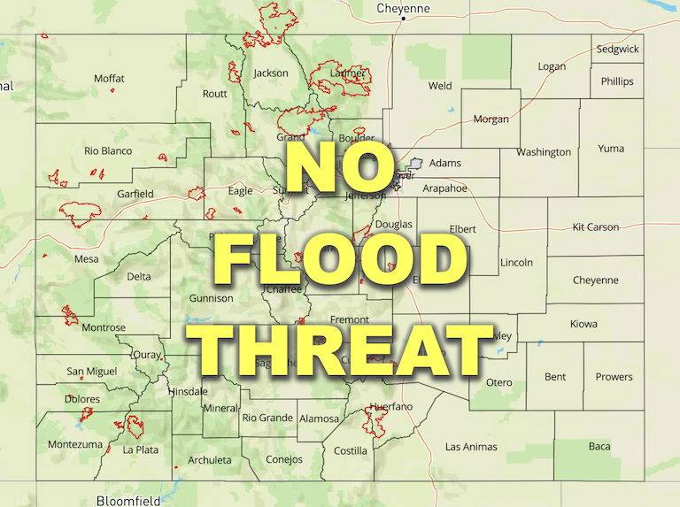
 Flooding is NOT expected today

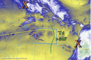
A quieter weather day is on tap as a weak ridge begins to build overhead. There are currently some ongoing light showers and cloud cover over the eastern plains associated with a departing shortwave (orange “X”, north). These should begin to wind down anytime now as the shortwave moves east with the westerly flow aloft. Out west, PW has risen to 0.53 inches at Grand Junction, which is helping produce the mid and upper-level clouds seen in the visible satellite imagery below. Still present in the sounding is a very dry surface layer, which means the isolated storms that develop this afternoon with upslope flow and some weak mid-level energy (north of I-70) will likely produce more brief wind/virga than meaningful rainfall. Nonetheless, it’s good to have a break from critical fire weather conditions.

PW at Denver was measure at 0.54 inches with a similar moisture profile to Grand Junction. One small difference was that there was a little bit better moisture measured in the boundary layer. This remaining moisture is expected to mix out from west to east through this afternoon as another surface Low develops over the Northeast Plains. This means that isolated, weak storms that do develop with the residual moisture over the Front Range and push into the Urban Corridor should produce only limited rainfall. Gusty outflow winds will likely attend the storms as well.

An area of stronger storms is anticipated to develop over the eastern plains along a dry line this afternoon. It is likely that the dry line sets up just west of the eastern Colorado border, which should constrain the areal impact of the storms. That also means that the richer surface moisture is likely to be located east of our border, limiting the heavy rainfall potential. Additionally, the storms are forecast to move at 25-30 mph, so between these two factors, rain rates are expected to remain under flood threat criteria. Therefore, flooding is NOT expected today.

Today’s Flood Threat Map

For more information on today’s flood threat, see the map below. If there is a threat, hover over the threat areas for more details, and click on burn areas to learn more about them. For Zone-Specific forecasts, scroll below the threat map.

Zone-Specific Forecasts:

Northeast Plains & Southeast Plains:

Stronger storms will develop this afternoon along a dry line as some mid-level energy moves through the flow to help kick the storms off. It is possible that the dry line sets up just east of the state, leaving the border counties rainless. There is less of a severe threat today, and if thunderstorms fire over the eastern border counties, they should quickly move to the east. Max 1-hour rain rates up to 1 inch along with small hail and gusty outflow winds will be possible under the stronger storms. Flooding is NOT expected.

Primetime: 2:30PM to 7PM

Front Range, Northern Mountains, Central Mountains, Northwest Slope, Urban Corridor & Palmer Ridge:

Isolated storms are forecast to develop mostly north of I-70 today into tonight. A second round of rainfall and cloud cover is likely over the Northwest Slope and Northern Mountains overnight into tomorrow morning. Over the Northwest Slope, only light rainfall is expected today with more notable totals by morning (up to 0.15 inches). Over the Front Range, Northern Mountains and Urban Corridor 30-minute rain rates up to 0.20 inches are possible. Flooding is NOT forecast.

Primetime: 2PM to Ongoing

Southeast Mountains, Raton Ridge, San Luis Valley, Southwest Slope, Grand Valley & San Juan Mountains:

Rainfall is not anticipated over these zones today, so flooding is NOT expected. Afternoon high temperatures should reach into the upper 80Fs across the lower elevations and Raton Ridge, 80F for the SLV and 70Fs for the mountain valleys.

FTB 06-04-2022: Isolated, Heavy Rainfall Possible East; Dry West

Issue Date: Saturday, June 4th, 2022
Issue Time: 10AM MDT 

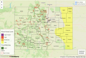
 LOW flood threat has been issued for portions of the Northeast & Southeast Plains

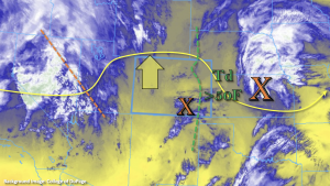
Taking a look at the water vapor imagery below, yesterday’s disturbance has now moved east into Kansas and Nebraska (large orange “X”). Today, a negatively tilted trough will continue to persist to our west as a weak ridge begins to build overhead, which will help increase afternoon high temperatures statewide. Unlike yesterday, there is no strong mid-level disturbance that is expected to move through the flow during peak heating, which means storms that do develop this afternoon and evening over eastern Colorado should be more isolated in nature. The main mesoscale feature to highlight today is a surface Low that is forecast to develop over the Southeast Plains, which should setup a nice dry line.

As the dry line sets up, the green dashed line (marks high dew points) should begin to sharpen. Downsloping winds over the Southeast Mountains should help keep this forecast zone and the adjacent plains rain-free today, although it is possible that some moisture may hang on over the Kansas/Colorado border for an isolated storm over eastern Baca or Prowers County. On the north side of the surface Low, more easterly and southeasterly surface winds should help maintain the higher moisture values over the Northeast Plains. These two features are expected to set the stage for another round of rainfall to fire over the northern Front Range and Cheyenne Ridge, and to a lesser extent the eastern Palmer Ridge, this afternoon. As these isolated to widely scattered storms are steered east into the deeper moisture and greater instability, they should begin to intensify. A couple severe storms will be possible over the Northeast Plains, which would also be capable of producing isolated heavy rainfall in the moisture rich environment. Therefore, a Low flood threat has been issued.

Back to the west, PW at Grand Junction was measured at 0.39 inches with a very dry conditions noted from the surface up to 3km. This, along with increasing heights, mean the majority of western Colorado should remain dry and hot this afternoon. There may be some isolated, weak storms that develop over the Northern Mountains and Front Range with a little mid-level energy skirting the northern tier of the state and some residual moisture, but rain rates and coverage should stay well below flood threat criteria.  

Today’s Flood Threat Map

For more information on today’s flood threat, see the map below. If there is a threat, hover over the threat areas for more details, and click on burn areas to learn more about them. For Zone-Specific forecasts, scroll below the threat map.

Zone-Specific Forecasts:

Front Range, Northern Mountains, Urban Corridor, Palmer Ridge, Northeast Plains & Southeast Plains:

Isolated storms may develop this afternoon over the Northern Mountains and Front Range. Max 30-minute rain rates up to 0.20 inches will be possible, but coverage should be limited with most storms producing totals under 0.15 inches. Gusty winds may accompany the stronger storms that develop.

Over the northern Urban Corridor, isolated storms may produce up to 0.35 inches of rainfall.  As storms move east, rain rates should increase with max 1-hour rain rates up 1.75 inches possible over the eastern plains. With several outflow boundaries likely in this area from yesterday’s rainfall, a storm may stall along the eastern border and produce locally high rainfall totals up to 3 inches. A Low flood threat has been issued for this area, but storms should be more isolated in coverage when compared to yesterday. Flood threats include road flooding, field ponding and rises in local creeks, especially if storms track over the same area as yesterday (saturated soils). A couple severe storms are also possible with the main threats being large hail and gusts up to 60mph. A isolated storm or two may develop further south in eastern Baca and Prowers County, depending on the location of the dry line, but it is more likely that the dry line sets up just east of the border. If these storms do develop over these areas, they should quickly move east, which will limit their flood threat.

Primetime: 12PM to 8PM (west); 4PM to 10PM (east)

San Luis Valley, Southeast Mountains, Raton Ridge, Central Mountains, Northwest Slope, Southwest Slope, Grand Valley & San Juan Mountains:

An isolated sprinkle or two may be possible over the San Juan and Central Mountains near the Continental Divide today. Otherwise, it should remain rain-free with high temperatures reaching up to 90F for the lower elevations, 80Fs for the SLV and mid to upper 70Fs for the mountain valleys. Flooding is NOT forecast. A Red Flag Warning has been issued for the SLV until 8PM tonight with west winds forecast in the 15 to 25 mph range and relative humidity dropping into the low teens.

FTB 06-03-2022: Scattered Severe Storms Out East, With Heavy Rainfall Potential

Issue Date: Friday, June 3rd, 2022
Issue Time: 10:30AM MDT

— A LOW flood threat has been posted for parts of the Palmer Ridge, Northeast Plains and Southeast Plains

The highest moisture content of the young summer season greeted us this morning, at least for eastern Colorado. As shown in the water vapor image, below, some of this moisture is coming from the remnants of yesterday’s convection. The upper-level feature is all the way in central Texas at this time, but a moist boundary layer along with an expansive low cloud deck remained over southeast Colorado this morning. This cloud deck should dissipate by noon, though with the differential solar heating over cloudy and cloud-free areas, could provide a focal point for convection later today.Morning PW at Denver measured in at 0.62 inches, while Grand Junction remained much drier at 0.37 inches. Statewide, PW has increased over the past 24-hours with values in the 0.6 to 0.9 inch range over eastern Colorado (notably drier to the west). More importantly, a sizeable portion of this moisture is held within the boundary layer with surface dewpoint temperatures as high as 55F over far southeast Colorado. PW is expected to remain steady or slightly increase as diurnal upslope easterly flow brings in some fresh moisture from the east. Instability will also be notably higher today with CAPE up to 2,000 J/kg expected over eastern Colorado with values up to 900 J/kg along the I-25 corridor.

With significant instability supporting strong thunderstorms, we next turn to look at dynamics. A notable mid-level disturbance is seen in the water vapor image, currently entering the Four Corner region. This will provide general synoptic scale lift for isolated to scattered shower and thunderstorm activity over central and eastern Colorado. Steering flow is weaker downstream (i.e. to the east) of this feature, with stronger steering flow to the west. Thus, expect slower storm motion with the initial storms, then faster storm motion by early evening. Wind shear is moderately strong today, and in tandem with instability will be very supportive of severe weather, most notably large hail (early) and then damaging winds.

To put everything together, we expected isolated to scattered showers and storms forming off our three elevated ridges by early afternoon: the Cheyenne Ridge, Palmer Ridge and Raton Ridge. Storms will move east/east-southeast and aggregate into clusters, growing in coverage through the afternoon. Heavy rainfall potential will be somewhat limited initially as storms will only have marginal moisture content. However, as they move east, the heavy rainfall potential will increase, warranting a general LOW flood threat for most of eastern Colorado for later this afternoon and into the early evening.

Today’s Flood Threat Map

For more information on today’s flood threat, see the map below. If there is a threat, hover over the threat areas for more details, and click on burn areas to learn more about them. For Zone-Specific forecasts, scroll below the threat map.

Zone-Specific Forecasts:

Northeast Plains, Southeast Plains, Front Range, Urban Corridor, Palmer Ridge, Southeast Mountains & Raton Ridge:

Becoming mostly cloudy with scattered showers and thunderstorms developing by early afternoon and increasing in coverage through the early evening. Max 30-min rain rates up to 1.0 inch (west) and 1.5 inches (east) possible, with max 1-hour rainfall up to 1.3 inches (west) and 2.2 inches (east). A LOW flood threat has been posted for mainly eastern portions of the area for isolated flash flooding. At least isolated severe weather is also expected this afternoon, with the early threat being large hail up to 1.5 inches. The threat of damaging winds will increase trough the afternoon as storms aggregate into clusters.

Primetime (west): 12PM through 8PM (west)
Primetime (east): 2PM through 10PM (east)

Northwest Slope, Northern Mountains, Grand Valley, Central Mountains, San Juan Mountains, Southwest Slope & San Luis Valley:

Partly cloudy with temperatures near or slightly above seasonal normal. An isolated shower or weak storm is expected mainly over higher elevations. Max 1-hour rainfall up to 0.4 inches. Flooding is NOT expected today.

Primetime: 11AM through 7PM