Issue Date: Friday, June 3rd, 2022
Issue Time: 10:30AM MDT
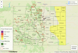
— A LOW flood threat has been posted for parts of the Palmer Ridge, Northeast Plains and Southeast Plains
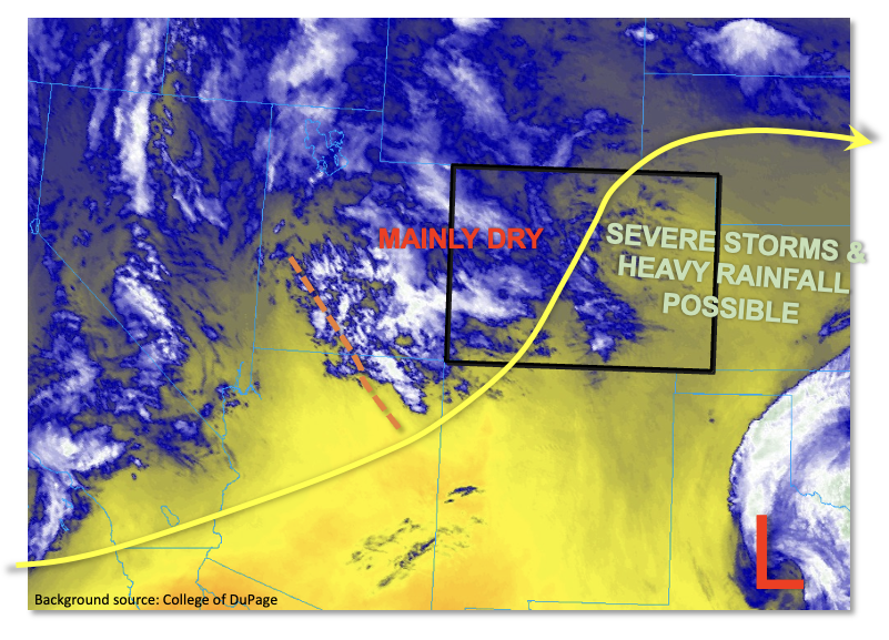
The highest moisture content of the young summer season greeted us this morning, at least for eastern Colorado. As shown in the water vapor image, below, some of this moisture is coming from the remnants of yesterday’s convection. The upper-level feature is all the way in central Texas at this time, but a moist boundary layer along with an expansive low cloud deck remained over southeast Colorado this morning. This cloud deck should dissipate by noon, though with the differential solar heating over cloudy and cloud-free areas, could provide a focal point for convection later today. Morning PW at Denver measured in at 0.62 inches, while Grand Junction remained much drier at 0.37 inches. Statewide, PW has increased over the past 24-hours with values in the 0.6 to 0.9 inch range over eastern Colorado (notably drier to the west). More importantly, a sizeable portion of this moisture is held within the boundary layer with surface dewpoint temperatures as high as 55F over far southeast Colorado. PW is expected to remain steady or slightly increase as diurnal upslope easterly flow brings in some fresh moisture from the east. Instability will also be notably higher today with CAPE up to 2,000 J/kg expected over eastern Colorado with values up to 900 J/kg along the I-25 corridor.
With significant instability supporting strong thunderstorms, we next turn to look at dynamics. A notable mid-level disturbance is seen in the water vapor image, currently entering the Four Corner region. This will provide general synoptic scale lift for isolated to scattered shower and thunderstorm activity over central and eastern Colorado. Steering flow is weaker downstream (i.e. to the east) of this feature, with stronger steering flow to the west. Thus, expect slower storm motion with the initial storms, then faster storm motion by early evening. Wind shear is moderately strong today, and in tandem with instability will be very supportive of severe weather, most notably large hail (early) and then damaging winds.
To put everything together, we expected isolated to scattered showers and storms forming off our three elevated ridges by early afternoon: the Cheyenne Ridge, Palmer Ridge and Raton Ridge. Storms will move east/east-southeast and aggregate into clusters, growing in coverage through the afternoon. Heavy rainfall potential will be somewhat limited initially as storms will only have marginal moisture content. However, as they move east, the heavy rainfall potential will increase, warranting a general LOW flood threat for most of eastern Colorado for later this afternoon and into the early evening.
Today’s Flood Threat Map
For more information on today’s flood threat, see the map below. If there is a threat, hover over the threat areas for more details, and click on burn areas to learn more about them. For Zone-Specific forecasts, scroll below the threat map.
Zone-Specific Forecasts:
Northeast Plains, Southeast Plains, Front Range, Urban Corridor, Palmer Ridge, Southeast Mountains & Raton Ridge:
Becoming mostly cloudy with scattered showers and thunderstorms developing by early afternoon and increasing in coverage through the early evening. Max 30-min rain rates up to 1.0 inch (west) and 1.5 inches (east) possible, with max 1-hour rainfall up to 1.3 inches (west) and 2.2 inches (east). A LOW flood threat has been posted for mainly eastern portions of the area for isolated flash flooding. At least isolated severe weather is also expected this afternoon, with the early threat being large hail up to 1.5 inches. The threat of damaging winds will increase trough the afternoon as storms aggregate into clusters.
Primetime (west): 12PM through 8PM (west)
Primetime (east): 2PM through 10PM (east)
Northwest Slope, Northern Mountains, Grand Valley, Central Mountains, San Juan Mountains, Southwest Slope & San Luis Valley:
Partly cloudy with temperatures near or slightly above seasonal normal. An isolated shower or weak storm is expected mainly over higher elevations. Max 1-hour rainfall up to 0.4 inches. Flooding is NOT expected today.
Primetime: 11AM through 7PM
