FTB 07-04-2015: Mother Nature to Provide Her Own Scattered Fireworks to Celebrate Independence Day

Issue Date: 7/4/2015
Issue Time: 9:46 AM

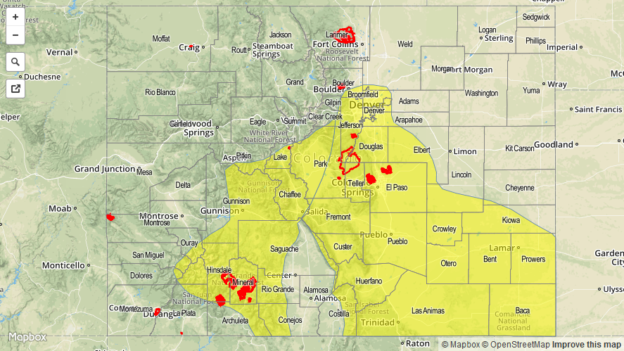
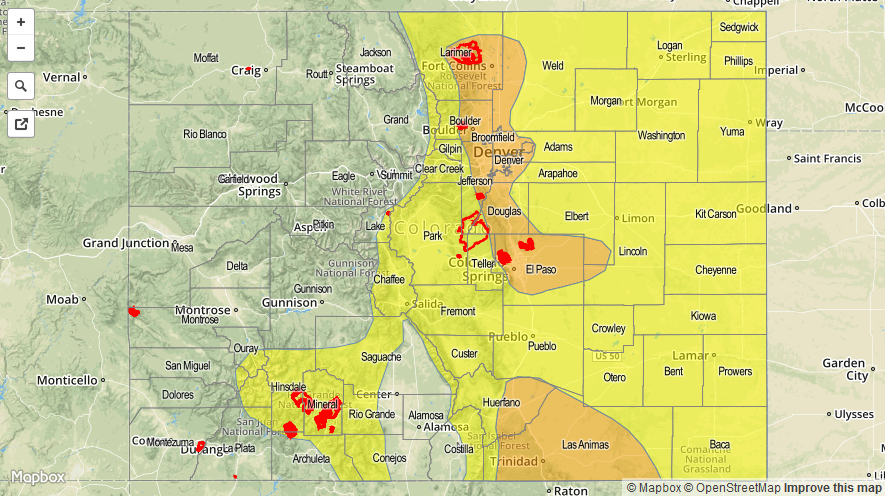
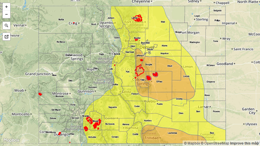
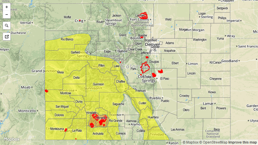
A MODERATE FLOOD THREAT IS IN PLACE FOR PORTIONS OF THE SAN JUAN MOUNTAINS. A LOW FLOOD THREAT IS IN PLACE FOR PORTIONS OF THE SOUTHWEST SLOPE, SAN JUAN MOUNTAINS, CENTRAL MOUNTAINS, NORTHWEST SLOPE, GRAND VALLEY, SOUTHEAST MOUNTAINS, AND RATON RIDGE.

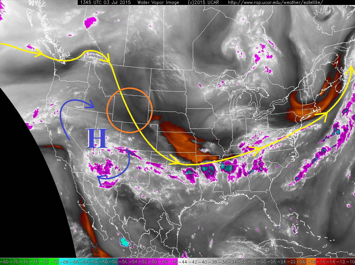
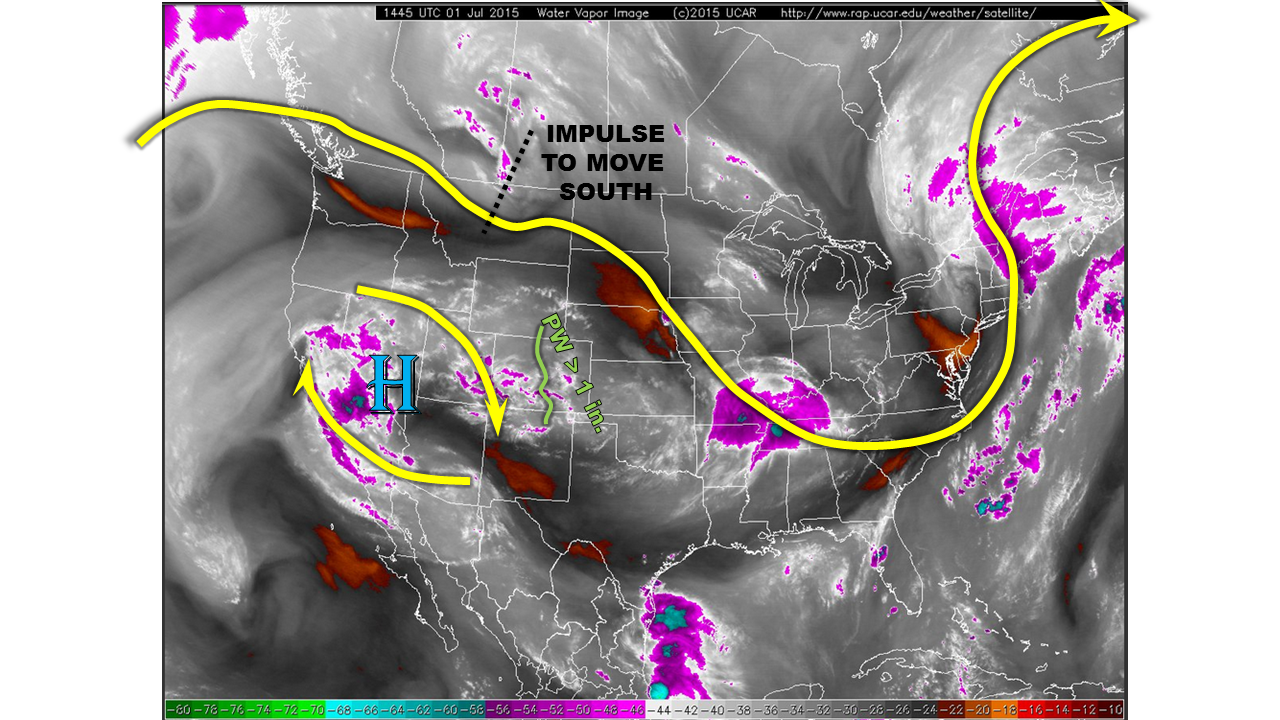
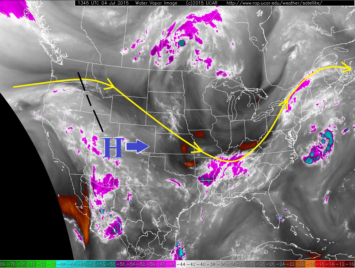
Changes are afoot today as the upper-level ridge shifts to the east, which will result in two main consequences: 1) Temperatures at the surface and aloft will rise a few degrees over yesterday, especially east of the Divide, and 2) West-northwest flow aloft will persist through the afternoon across western Colorado, but moist, southerly flow will return overnight and into tomorrow morning. So, what does this mean for our flood threat forecast?

07042015_WV

First, the rising temperatures at the surface and aloft across Eastern Colorado will tend to suppress thunderstorms, resulting in more isolated coverage. However, there is still sufficient moisture remaining under the ridge, so strong surface heating will still result in thunderstorms developing first over the mountains and foothills (between 11 AM and Noon), moving east over the plains during the afternoon and evening. Cloud bases will tend to be higher today than previous days, so the main threats east of the mountains will be lightning, strong outflow winds, and brief moderate rainfall. The exception to this, because of course there is an exception, will be across the far Northeast and Southeast Plains, where better low-level moisture and instability will reside east of a surface trough.

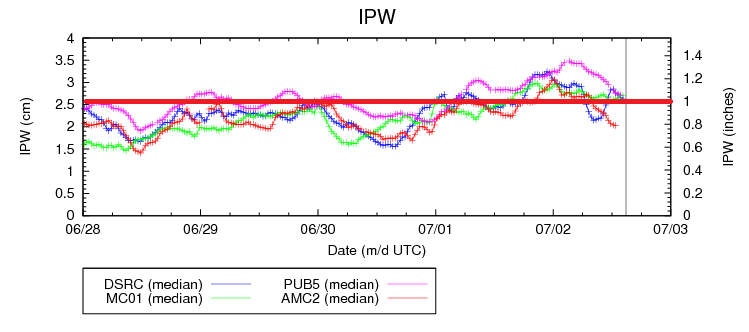
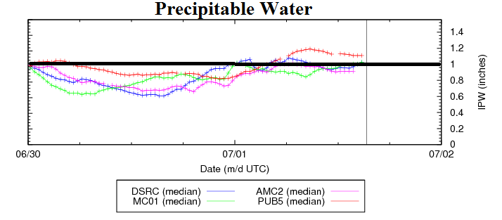
Second, west-northwest flow aloft will keep precipitable water values over western Colorado well above-normal, as there is still plenty of moisture available upstream. This will result in another afternoon and evening of scattered thunderstorms, mainly over the higher terrain and adjacent lower valleys. Lightning, strong outflow winds, small hail, and brief heavy rain will all be threats with thunderstorm activity this afternoon and evening. The best relative chance for heavy rain will be over southern regions, i.e., Southwest Slope and San Juan Mountains. As we head into the overnight hours and the upper-level ridge continues to slide east, moist, southwesterly flow will return to western Colorado, pushing precipitable water values at, or above, 1 inch for tomorrow. Far western Colorado, near the CO/UT border and 4-corners region, will hold the flood threat into tomorrow morning.

Today’s Flood Threat Map

For more information on today’s flood threat, see the map below (hover over threat areas for more details). For Zone-Specific forecasts, jump below the map.

07042015_MFT
Flood Threat Legend

Zone-Specific Forecasts

Front Range, Urban Corridor, Palmer Ridge, Northeast Plains, Southeast Plains, and Raton Ridge:

Isolated-to-widely scattered thunderstorms will be possible this afternoon and evening. Otherwise, mostly sunny skies and hot temperatures will be the main story today. Far eastern portions of the Northeast Plains and Southeast Plains will hold the opportunity for severe thunderstorms this afternoon and evening, as the best moisture, instability, and shear will reside along the developing surface trough. For other areas, storms will be higher based than the past few days, resulting in the main threats being lightning, gusty outflow winds, and brief moderate rainfall. Maximum rain rates will vary, and are as follows:

Northeast Plains, Southeast Plains, and Palmer Ridge: 1.5-2.5 inches/hour.
Front Range and Urban Corridor: 0.6-1.2 inches/hour
Raton Ridge: 0.8-1.2 inches/hour

Central Mountains, San Luis Valley, Southeast Mountains, Northern Mountains, and Northwest Slope:

Scattered thunderstorms expected for the Central Mountains, San Luis Valley, and Southeast Mountains, mainly over the higher terrain and adjacent valleys this afternoon and evening. There will be more coverage over the Northern Mountains and Northwest Slope than previous days, but will still be in the isolated category. During the day, lightning, small hail, gusty outflow winds, and brief heavy rain will be the main threats. Overnight, the concern will shift to more widespread coverage over the Northwest Slope, with thunderstorms producing efficient rainfall. Max rain rates are as follows:

Central Mountains, Southeast Mountains, Northern Mountains, and San Luis Valley: 0.5-1.0 inches/hour
Northwest Slope: 0.25-0.5 inches/hour during the day, and then 0.6-1.0 inches/hour overnight.

San Juan Mountains, Southwest Slope, and Grand Valley:

Scattered thunderstorms expected through this evening, mainly across the higher elevations and adjacent valleys. As the upper-level ridge shifts eastward, moisture values will climb to near record levels tomorrow morning. Even though daytime heating will not be able to help thunderstorms overnight and during the early morning hours, the support will be provided by a passing shortwave embedded in the southwest flow. More widespread coverage is expected, with thunderstorms producing efficient rainfall. Maximum rain rates will be in the 1.0-1.5 inches/hour during the afternoon and evening, shifting to 0.7-1.1 inches/hour overnight.

FTB 07-03-2015: DRIER AIR PUSHING IN FROM THE NORTH, BUT HEAVY RAIN STILL POSSIBLE TODAY

Issue Date: 7/3/2015
Issue Time: 9:36 AM

LOW FLOOD THREAT IS FORECAST FOR PORTIONS OF THE FRONT RANGE, URBAN CORRIDOR, CENTRAL MOUNTAINS, SAN JUAN MOUNTAINS, SOUTHEAST MOUNTAINS, PALMER RIDGE, RATON RIDGE AND SOUTHEAST PLAINS.

With an introduction that seems like a broken record, the upper-level ridge over the western US remains entrenched, however subtle changes are underway. The most notabe change is the elongation of the high pressure circulation (shown with the blue arrows) as a result of the flattening of the ridge. This is allowing for drier air to slowly work in from the north (circled in orange), which will push the best moisture southward. In short, this means the heaviest rainfall will occur with storms south of I-70 today. However, with sufficient instability in place this afternoon as daytime heating warms the surface, isolated strong thunderstorms cannot be ruled out north of I-70 along the Front Range foothills and Urban Corridor.

07032015_WV

The main threat from heavy rain will exist across southern portions of the Front Range and Urban Corridor, as well as the San Juan Mountains, Southeast Mountains, Raton Ridge, and Southeast Plains. The best moisture will reside across these locations, with precipitable water values hanging near, or just above, 1 inch this afternoon and evening. Overnight, there will be another weak, mid-level disturbance rotate across eastern Colorado, providing widely scattered showers and thunderstorms into the early morning hours.

Today’s Flood Threat Map

For more information on today’s flood threat, see the map below (hover over threat areas for more details). For Zone-Specific forecasts, jump below the map.

07032015_LFT
Flood Threat Legend

Zone-Specific Forecasts

Front Range, Urban Corridor, Palmer Ridge, Northeast Plains, Southeast Plains, and Raton Ridge:

Scattered showers and thunderstorms expected, with high temperatures a few degrees warmer than yesterday. A few strong-to-severe storms will be possible, as instability and wind shear remain favorable for a few supercells capable of large hail (1+ inch) and strong winds. Brief heavy rainfall will also be a threat with the stronger storms, but storm motions should be quick enough to mitigate potential flooding impacts. With that said, the maximum rain rates are as follows:

Northeast Plains: 0.6-1.2 inches/hour
Front Range and Urban Corridor, north of I-70: 0.8-1.2 inches/hour
Front Range and Urban Corridor, along and south of I-70: 1.0-2.0 inches/hour
Palmer Ridge, Southeast Plains, and Raton Ridge: 1.5-2.5 inches/hour

Timing: 11 AM – 10 PM, with a few lingering overnight with the passage of a weak, mid-level disturbance

Northern Mountains, Northwest Slope, and Grand Valley:

Isolated thunderstorms, mainly over the higher terrain. A few will move over adjacent valleys thanks to southerly storm motions. Maximum rain rates will be 0.4-0.6 inches/hour, with the main threats from thunderstorms being lightning and strong outflow winds.

Timing: 11 AM – 7 PM

Central Mountains, San Juan Mountains, San Luis Valley, Southeast Mountains, Southwest Slope:

Scattered showers and thunderstorms expected across these regions, mainly over the higher terrain. Adjacent low elevations/valleys will see a few thunderstorms move overhead due to southerly storm motions. Moisture will remain deepest over these southern regions, so brief heavy rainfall will be a threat, as well as hail (0.5-1.0 inch), lightning, and gusty winds. Storm motions will help to mitigate the flooding threat. Maximum rain rates are as follows:

Central Mountains: 0.6-1.2 inches/hour
Southeast Mountains: 1.5-2.5 inches/hour
San Juan Mountains: 1.2-1.8 inches/hour
San Luis Valley: 0.6-1.0 inches/hour
Southwest Slope: 0.4-0.8 inches/hour

Timing: 11 AM – 10 PM, with a few lingering into the early morning hours over the San Juan Mountains and Southwest Slope.

FTB 07-02-2015: Deep Moisture Available to Thunderstorms, Heavy Rainfall Possible

Issue Date: 7/2/2015
Issue Time: 10:03 AM

MODERATE FLOOD THREAT IS IN PLACE FOR PORTIONS OF THE FRONT RANGE, URBAN CORRIDOR, PALMER RIDGE, SOUTHEAST PLAINS, AND RATON RIDGE.

LOW FLOOD THREAT IS IN PLACE FOR PORTIONS OF THE FRONT RANGE, NORTHERN MOUNTAINS, CENTRAL MOUNTAINS, SOUTHEAST MOUNTAINS, RATON RIDGE, SAN JUAN MOUNTAINS, SOUTHEAST PLAINS, NORTHEAST PLAINS, AND PALMER RIDGE.

The upper-level ridge continues to stay entrenched over the western US, providing Colorado another day of northwesterly flow aloft. Within this northwesterly flow is a couple of embedded disturbances that will make today and tonight fairly active for much of the state. Heavy rain is likely with stronger thunderstorms, as this morning’s soundings measured precipitable water within the 90th percentile for the date. A quick glance at the precipitable water chart for the normal 4 reporting stations shows this moisture clearly: Boulder, Grand Junction, and Pueblo are all at, or above, 1 inch at this time. Measurements from Shriever AFB show around 0.8 inches IPW, but this will likely rebound this afternoon.

07022015_IPW

There will be an ample amount of shear and instability available to thunderstorms today, and a few supercells are likely, particularly across the Urban Corridor and Palmer Ridge this afternoon. The main threats from these strong-to-severe storms will be large hail, strong winds, and locally heavy rainfall. For more information on rain rates, check the zone-specific forecast discussions below.

Overnight, another round of showers and thunderstorms is possible for the Urban Corridor, Palmer Ridge, Northeast Plains, and Southeast Plains regions. Much like this morning’s thunderstorms, they will be garden variety, but locally heavy rainfall will be possible, and the low threat of flash flooding will continue into tomorrow morning, with the main concern being locations that received heavy rain during the afternoon/evening hours.

Today’s Flood Threat Map

For more information on today’s flood threat, see the map below (hover over threat areas for more details). For Zone-Specific forecasts, jump below the map.

07022015_MFT
Flood Threat Legend

Zone-Specific Forecasts

Front Range, Urban Corridor, Palmer Ridge, Northeast Plains, Southeast Plains, and Raton Ridge:

Cooler than the past few days, but scattered showers and thunderstorm are likely across these regions. A few will become severe, with the highest relative chances of reaching severe thresholds along the Urban Corridor and Palmer Ridge. The main threat from severe thunderstorms will be large hail, strong winds, and heavy rainfall. At any rate, most thunderstorms will be efficient rain-producers today, with maximum rain rates as high as 2-2.5 inches/hour. Area burn scars and urban areas with expanses of impervious surfaces will be most susceptible to flash flooding today.

Timing: Noon – 11 PM will be the main threat period, with a secondary threat lasting through the night into tomorrow morning as mentioned above.

Northern Mountains, Northwest Slope, and Grand Valley:

Isolated showers and thunderstorms possible over the higher terrain of the Northern Mountains and Grand Valley. The Northwest Slope will remain mostly dry, but one or two isolated weak showers/thunderstorms over higher terrain cannot be ruled completely out. Maximum rain rates are as follows:

Northwest Slope: 0.25-0.4 inches/hour
Northern Mountains: 0.4-0.6 inches/hour
Grand Valley: 0.4-0.8 inches/hour

Timing: 11 AM – 7 PM

Central Mountains, San Juan Mountains, San Luis Valley, Southeast Mountains, Southwest Slope:

Scattered showers and thunderstorms expected, with the greatest relative coverage occurring over the Central Mountains, San Juan Mountains, and Southeast Mountains. With the amount of moisture present in the atmosphere, locally heavy rainfall will be a threat. Maximum rain rates are as follows:

Central Mountains and Southeast Mountains: 1.0-1.6 inches/hour
San Juan Mountains: 0.8-1.4 inches/hour
San Luis Valley: 0.6-1.0 inches/hour
Southwest Slope: 0.5-0.8 inches/hour

Timing: 11 AM – 10 PM, with a few showers and thunderstorms lingering into the early morning hours.

FTB 07-01-2015: After Short Hiatus, Heavy Rainfall Back In The Picture Today

Issue Date: 7/1/2015
Issue Time: 10:45AM

— High flood threat for Waldo Canyon and Black Forest fire burn areas
— Moderate flood threat for Palmer Ridge, Raton Ridge and parts of Urban Corridor
— Low flood threat for most of central and southern Colorado

After taking a very short break, Mother Nature is back in action today, providing several ingredients for a possible period of very heavy rainfall across Colorado this afternoon and evening. The setup for today is shown in the water vapor image, below. The upper-level ridge that maintained mainly dry weather yesterday has slightly weakened and moved off to the west. Meanwhile, an impressive impulse in the jet stream was located on the border of Montana/Canadian border. This impulse will move south and east and “dig”, meaning that it will cool upper-level temperatures. Thus, the upper-level dynamics will be supportive of thunderstorms today.

watervapor_20150701

The upper-level situation is only half of the story, as low-level conditions also indicate moistening of the atmosphere since yesterday. The chart below shows that precipitable water values have increased by 30-40% since yesterday morning and now sit near or above 1 inch at all four Colorado sites that we typically monitor.

IPW_20150701

For today, we expect sunny/hazy skies this morning to quickly give way to storm clouds by early afternoon. As is usually the case, storms will initially develop along the higher terrain, mainly east of the Divide. These storms will mature and lead to new storm formation eastward into the Plains. Due to the moist atmosphere and favorable dynamics, 1-hr rain amounts up to 2-inches will be possible over many areas east of the Divide. The low-level wind field suggests the Palmer Ridge and Raton Ridge will see the highest rainfall threat, warranting a Moderate flood threat. A High flood threat is in place for both the Waldo Canyon and Black Forest fire burns in El Paso county. A Low flood threat is in place elsewhere. Activity will subside late this evening as atmospheric heating wanes.

Today’s Flood Threat Map

For more information on today’s flood threat, see the map below (hover over threat areas for more details). For Zone-Specific forecasts, jump below the map.

07012015_HFT
Flood Threat Legend

Zone-Specific Forecasts

Northeast Plains, Front Range, Urban Corridor, Palmer Ridge, Southeast Plains, Raton Ridge, Southeast Mountains:

Mostly sunny early with thunderstorms forming by early afternoon. One-hour rainfall up to 2-inches will be possible across many areas, with 3-hr amounts up to 3 inches possible mainly over the Palmer and Raton Ridges. The Waldo Canyon and Black Forest fire burn areas are especially vulnerable today, and significant runoff of mud and debris will be possible there. Hail, up to 1 inch, may also accompany the strongest storms, especially earlier in the afternoon.

Primetime: 1pm to midnight for the Low threat, 3pm to 10pm for the Moderate, 3pm to 8pm for the High

Central Mountains, Northern Mountains, San Juans, San Luis Valley, Southwest Slope:

Mostly sunny early, then partly cloudy with isolated to scattered thunderstorms forming by early afternoon. One hour rain rates up to 1.1 inches will lead to isolated flash flooding, debris slides and mud flows. Coverage and intensity will be highest the farther east one moves.

Primetime: 1pm to 9pm

Grand Valley, Northwest Slope:

Mostly sunny and continued hot today with high temperatures up to 105F in the lowest elevations. An isolated thunderstorms moving in from the higher terrain is not impossible, but will produce more of a gusty wind and lightning threat that any rainfall.