Issue Date: 7/2/2015
Issue Time: 10:03 AM
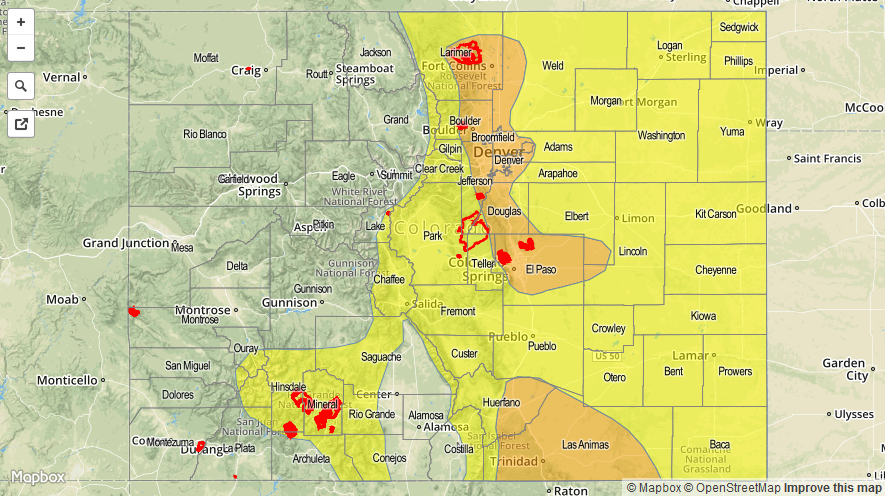
MODERATE FLOOD THREAT IS IN PLACE FOR PORTIONS OF THE FRONT RANGE, URBAN CORRIDOR, PALMER RIDGE, SOUTHEAST PLAINS, AND RATON RIDGE.
LOW FLOOD THREAT IS IN PLACE FOR PORTIONS OF THE FRONT RANGE, NORTHERN MOUNTAINS, CENTRAL MOUNTAINS, SOUTHEAST MOUNTAINS, RATON RIDGE, SAN JUAN MOUNTAINS, SOUTHEAST PLAINS, NORTHEAST PLAINS, AND PALMER RIDGE.
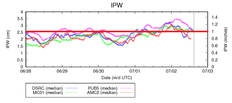
The upper-level ridge continues to stay entrenched over the western US, providing Colorado another day of northwesterly flow aloft. Within this northwesterly flow is a couple of embedded disturbances that will make today and tonight fairly active for much of the state. Heavy rain is likely with stronger thunderstorms, as this morning’s soundings measured precipitable water within the 90th percentile for the date. A quick glance at the precipitable water chart for the normal 4 reporting stations shows this moisture clearly: Boulder, Grand Junction, and Pueblo are all at, or above, 1 inch at this time. Measurements from Shriever AFB show around 0.8 inches IPW, but this will likely rebound this afternoon.
There will be an ample amount of shear and instability available to thunderstorms today, and a few supercells are likely, particularly across the Urban Corridor and Palmer Ridge this afternoon. The main threats from these strong-to-severe storms will be large hail, strong winds, and locally heavy rainfall. For more information on rain rates, check the zone-specific forecast discussions below.
Overnight, another round of showers and thunderstorms is possible for the Urban Corridor, Palmer Ridge, Northeast Plains, and Southeast Plains regions. Much like this morning’s thunderstorms, they will be garden variety, but locally heavy rainfall will be possible, and the low threat of flash flooding will continue into tomorrow morning, with the main concern being locations that received heavy rain during the afternoon/evening hours.
Today’s Flood Threat Map
For more information on today’s flood threat, see the map below (hover over threat areas for more details). For Zone-Specific forecasts, jump below the map.

Zone-Specific Forecasts
Front Range, Urban Corridor, Palmer Ridge, Northeast Plains, Southeast Plains, and Raton Ridge:
Cooler than the past few days, but scattered showers and thunderstorm are likely across these regions. A few will become severe, with the highest relative chances of reaching severe thresholds along the Urban Corridor and Palmer Ridge. The main threat from severe thunderstorms will be large hail, strong winds, and heavy rainfall. At any rate, most thunderstorms will be efficient rain-producers today, with maximum rain rates as high as 2-2.5 inches/hour. Area burn scars and urban areas with expanses of impervious surfaces will be most susceptible to flash flooding today.
Timing: Noon – 11 PM will be the main threat period, with a secondary threat lasting through the night into tomorrow morning as mentioned above.
Northern Mountains, Northwest Slope, and Grand Valley:
Isolated showers and thunderstorms possible over the higher terrain of the Northern Mountains and Grand Valley. The Northwest Slope will remain mostly dry, but one or two isolated weak showers/thunderstorms over higher terrain cannot be ruled completely out. Maximum rain rates are as follows:
Northwest Slope: 0.25-0.4 inches/hour
Northern Mountains: 0.4-0.6 inches/hour
Grand Valley: 0.4-0.8 inches/hour
Timing: 11 AM – 7 PM
Central Mountains, San Juan Mountains, San Luis Valley, Southeast Mountains, Southwest Slope:
Scattered showers and thunderstorms expected, with the greatest relative coverage occurring over the Central Mountains, San Juan Mountains, and Southeast Mountains. With the amount of moisture present in the atmosphere, locally heavy rainfall will be a threat. Maximum rain rates are as follows:
Central Mountains and Southeast Mountains: 1.0-1.6 inches/hour
San Juan Mountains: 0.8-1.4 inches/hour
San Luis Valley: 0.6-1.0 inches/hour
Southwest Slope: 0.5-0.8 inches/hour
Timing: 11 AM – 10 PM, with a few showers and thunderstorms lingering into the early morning hours.