Issue Date: 7/1/2015
Issue Time: 10:45AM
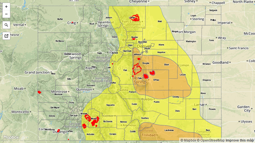
— High flood threat for Waldo Canyon and Black Forest fire burn areas
— Moderate flood threat for Palmer Ridge, Raton Ridge and parts of Urban Corridor
— Low flood threat for most of central and southern Colorado
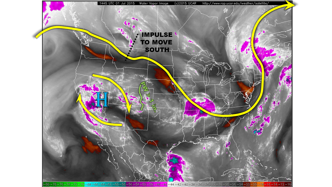
After taking a very short break, Mother Nature is back in action today, providing several ingredients for a possible period of very heavy rainfall across Colorado this afternoon and evening. The setup for today is shown in the water vapor image, below. The upper-level ridge that maintained mainly dry weather yesterday has slightly weakened and moved off to the west. Meanwhile, an impressive impulse in the jet stream was located on the border of Montana/Canadian border. This impulse will move south and east and “dig”, meaning that it will cool upper-level temperatures. Thus, the upper-level dynamics will be supportive of thunderstorms today.
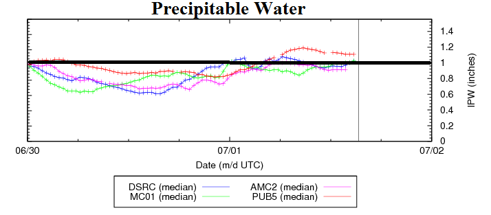
The upper-level situation is only half of the story, as low-level conditions also indicate moistening of the atmosphere since yesterday. The chart below shows that precipitable water values have increased by 30-40% since yesterday morning and now sit near or above 1 inch at all four Colorado sites that we typically monitor.
For today, we expect sunny/hazy skies this morning to quickly give way to storm clouds by early afternoon. As is usually the case, storms will initially develop along the higher terrain, mainly east of the Divide. These storms will mature and lead to new storm formation eastward into the Plains. Due to the moist atmosphere and favorable dynamics, 1-hr rain amounts up to 2-inches will be possible over many areas east of the Divide. The low-level wind field suggests the Palmer Ridge and Raton Ridge will see the highest rainfall threat, warranting a Moderate flood threat. A High flood threat is in place for both the Waldo Canyon and Black Forest fire burns in El Paso county. A Low flood threat is in place elsewhere. Activity will subside late this evening as atmospheric heating wanes.
Today’s Flood Threat Map
For more information on today’s flood threat, see the map below (hover over threat areas for more details). For Zone-Specific forecasts, jump below the map.

Zone-Specific Forecasts
Northeast Plains, Front Range, Urban Corridor, Palmer Ridge, Southeast Plains, Raton Ridge, Southeast Mountains:
Mostly sunny early with thunderstorms forming by early afternoon. One-hour rainfall up to 2-inches will be possible across many areas, with 3-hr amounts up to 3 inches possible mainly over the Palmer and Raton Ridges. The Waldo Canyon and Black Forest fire burn areas are especially vulnerable today, and significant runoff of mud and debris will be possible there. Hail, up to 1 inch, may also accompany the strongest storms, especially earlier in the afternoon.
Primetime: 1pm to midnight for the Low threat, 3pm to 10pm for the Moderate, 3pm to 8pm for the High
Central Mountains, Northern Mountains, San Juans, San Luis Valley, Southwest Slope:
Mostly sunny early, then partly cloudy with isolated to scattered thunderstorms forming by early afternoon. One hour rain rates up to 1.1 inches will lead to isolated flash flooding, debris slides and mud flows. Coverage and intensity will be highest the farther east one moves.
Primetime: 1pm to 9pm
Grand Valley, Northwest Slope:
Mostly sunny and continued hot today with high temperatures up to 105F in the lowest elevations. An isolated thunderstorms moving in from the higher terrain is not impossible, but will produce more of a gusty wind and lightning threat that any rainfall.