FTB 09-22-2015: Low Flood Threat Makes a Return

Issue Date: 9/22/2015
Issue Time: 9:17 AM

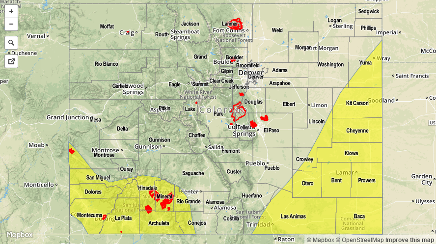
A LOW FLOOD THREAT IS FORECAST FOR PORTIONS OF THE SOUTHWEST SLOPE, SAN JUAN MOUNTAINS, RATON RIDGE, SOUTHEAST PLAINS, PALMER RIDGE, AND NORTHEAST PLAINS REGIONS.

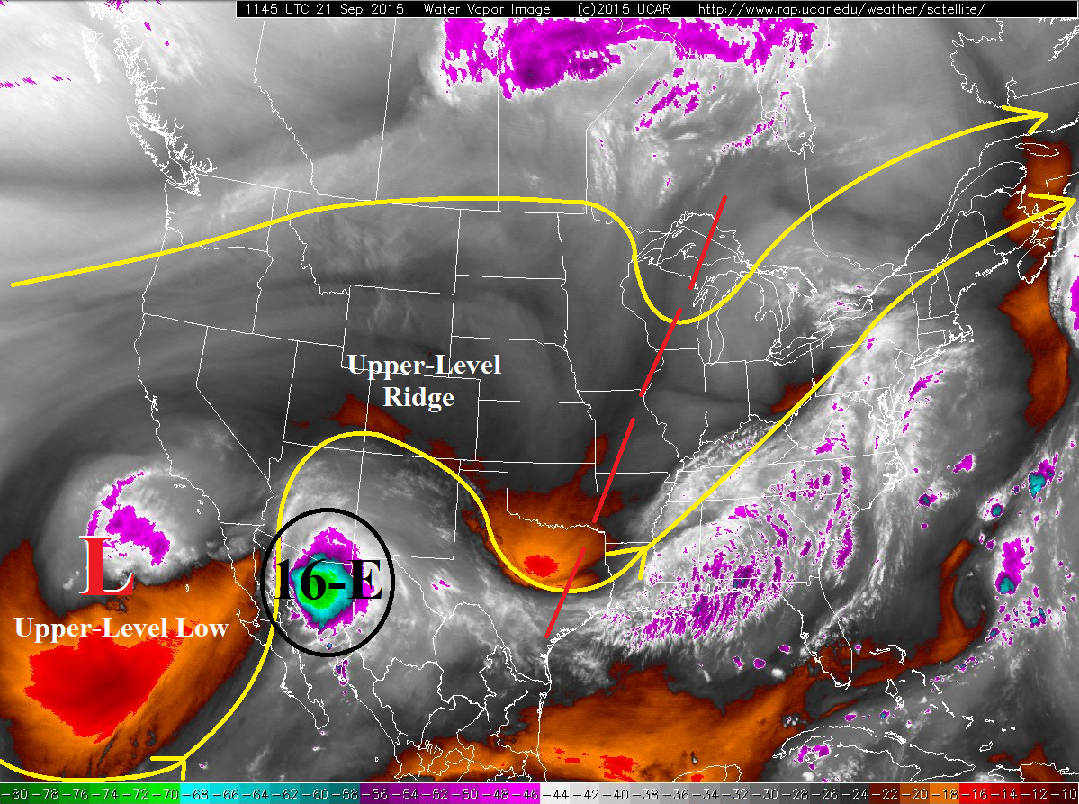
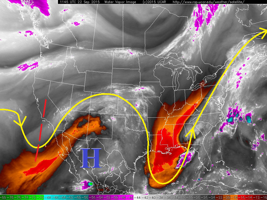
The moisture remnants of Tropical Depression Sixteen-E are easily spotted across Colorado this morning, with the bright white colors indicating ample mid- and upper-level moisture. This increase in moisture has been accompanied by an increase in cloud cover, and all of these ingredients will have an impact on today’s forecast. First of all, the increase in cloud cover will lead to high temperatures that are cooler than the past few days, giving the air a more autumn-like feel. Second, the increase in moisture will lead to an increase in showers/thunderstorms today, and a few will produce heavy rain. To break down where this is likely to occur, we need to look at the lower levels of the atmosphere.

WV_09222015

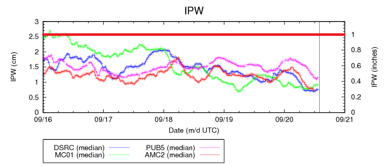
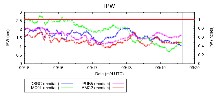
The lower levels hold the key to today’s flood threat bulletin, as much of the state remains dry below 500 mb. The regions with the best moisture will be the San Juan Mountains, San Luis Valley, Raton Ridge, and eastern portions of the Southeast Plains, Palmer Ridge, and Northeast Plains. Precipitable water values over the San Juan Mountain and San Luis Valley regions will reach near 0.75 inches. Further east, southerly surface flow will increase through the afternoon, bringing in good low-level moisture for the other aforementioned regions, especially for locations along the CO/KS border where precipitable water values will climb to 1.25-1.50 inches. This amount of moisture available will lead to efficient rainfall production. On the other hand, the flood threat will be limited by widespread cloud cover reducing instability and dry antecedent conditions, so only a low flood threat is warranted.

Please check the zone-specific discussions below for more information.

Today’s Flood Threat Map

For more information on today’s flood threat, see the map below (hover over threat areas for more details). For Zone-Specific forecasts, jump below the map.

20150922_LFT
Flood Threat Legend

Zone-Specific Forecasts

Northwest Slope and Grand Valley:

Partly sunny and mainly dry, with high temperatures near average for the date. The best moisture and dynamics will stay south of the area, leaving these regions as the most pleasant across Colorado for today. Clouds will increase during the afternoon over the higher elevations, but nothing more than a sprinkle will result.

Northern Mountains, Front Range, Southeast Mountains, and Central Mountains:

Isolated-to-scattered showers and weak thunderstorms expected, with chances increasing from north to south. Maximum rain rates will sit between 0.4-0.7 inches/hour, with most activity producing rainfall at 0.25-0.5 inches/hour. Otherwise, mostly cloudy skies and cooler temperatures will be the main impacts from today’s weather system.

Timing: Noon – 6 AM

San Luis Valley, San Juan Mountains, and Southwest Slope:

Scattered showers and thunderstorms expected, with the best chances over the higher terrain and near the CO/NM border where low-level moisture will be best. Maximum rain rates will be 1.0-1.5 inches/hour. Otherwise, today will be filled with cloud cover and cooler temperatures.

Timing: Current – 9 AM

Urban Corridor:

Partly sunny with isolated showers/weak thunderstorms expected during the afternoon/evening hours. The best chances for rainfall will be south of Denver. Maximum rain rates will be 0.4-0.7 inches/hour.

Timing: 4 PM – Midnight

Northeast Plains, Southeast Plains, Palmer Ridge, and Raton Ridge:

Scattered showers and thunderstorms expected this afternoon and evening, with lingering activity into the overnight and morning hours tomorrow. Precipitable water values will increase through the afternoon and southerly surface flow advects in good low-level moisture, pushing dewpoints into the upper 50’s and near 60. Maximum one hour rain rates will break down like this:

Raton Ridge and Southeast Plains: 1.8-2.2 inches/hour
Palmer Ridge: 1.0-1.6 inches/hour
Northeast Plains: 0.8-1.2 inches/hour

Timing: 1 PM – Midnight, with locations near the CO/KS border experiencing lingering storms into tomorrow morning (~6 AM).

FTB 09-21-2015: Another Dry and Warm Day, Some Changes Overnight

Issue Date: 9/21/2015
Issue Time: 9:00 AM

NO FLOOD THREAT IS FORECAST.

Under the influence of an upper-level ridge, Colorado will once again be dry and warm today. High temperatures across the state will be 4-10 degrees above average for the date under mostly sunny skies. Overall, winds will be fairly light except for far southeastern portions of the Southeast Plains region where gusts could reach 20 mph this afternoon/evening. Some changes are on the way for overnight tonight/tomorrow, as the upper-level low off the southern CA/Baja coast helps to funnel Tropical Depression Sixteen-E’s remnants across CA/AZ/NM. The flash flood threat is high for those states; Flash Flood Watches have been issued for portions of all three states.

09212015_WV

The moisture plume will begin to encroach on Colorado during the evening hours as upper-level clouds will begin to filter across southern Colorado, and then overnight a thicker cloud deck will arrive over southwest Colorado. A few showers during the overnight/morning hours will be possible across the San Juan Mountains and Southwest Slope regions; otherwise, the main impact during this forecast period will be mild overnight lows as clouds serve as a “blanket” for outgoing radiation.

Today’s Flood Threat Map

For more information on today’s flood threat, see the map below (hover over threat areas for more details). For Zone-Specific forecasts, jump below the map.

Flood Threat Legend

Zone-Specific Forecasts

Urban Corridor, Northeast Plains, Raton Ridge, Palmer Ridge, and Southeast Plains:

Dry and hot for this time of year, with high temperatures 4-8 degrees above average. Denver’s high temperature record of 88 F will flirt with being tied/broken this afternoon. High clouds will increase during the evening and overnight hours, especially for southern regions. No precipitation is expected.

Front Range, Northern Mountains, Northwest Slope, Central Mountains, Grand Valley, San Juan Mountains, Southwest Slope, Southeast Mountains, and San Luis Valley:

Mostly sunny and warm, with high temperatures 5-10 degrees above average across the area. High-level clouds will increase during the late afternoon and evening hours, with mid-level clouds moving in overnight for southern/southwestern regions. A few isolated showers will accompany the mid-level clouds overnight for the Southwest Slope and San Juan Mountains regions, resulting in no more than light rain (0.25 inches/hour maximum).

Timing: Midnight – 11 AM

FTB 09-20-2015: Dry and Warm End to the Weekend

Issue Date: 9/20/2015
Issue Time: 9:03 AM

NO FLOOD THREAT IS FORECAST.

Inching nearer to the end of the FTB season, no flood threats become increasingly common as precipitable water, on average, falls throughout the month of September. A quick glance at the IPW chart below shows a steady decrease in moisture over the last 4 days or so, and this pattern will continue today. The dry air mass over Colorado will warm quickly today, allowing temperatures to climb a few degrees higher than yesterday. There isn’t much else to discuss in today’s forecast other than to get outside and enjoy the sunshine and warmth.

09202015_IPW

Today’s Flood Threat Map

For more information on today’s flood threat, see the map below (hover over threat areas for more details). For Zone-Specific forecasts, jump below the map.

Flood Threat Legend

Zone-Specific Forecasts

Urban Corridor, Northeast Plains, Raton Ridge, Palmer Ridge, and Southeast Plains:

Mostly sunny and warm, with high temperatures climbing a few degrees higher than yesterday. Overnight, the clear skies and dry air will allow for plenty of cooling, resulting in chilly overnight low temperatures.

Front Range, Northern Mountains, Northwest Slope, Central Mountains, Grand Valley, San Juan Mountains, Southwest Slope, Southeast Mountains, and San Luis Valley:

Abundant sunshine with high temperatures warming a few degrees higher than yesterday. Overnight, the clear skies and dry air will allow for temperatures to cool quickly, resulting in temperatures falling into the upper 30s/low 40s for lower valleys and to near, or just below, freezing across the higher elevations.

FTB 09-19-2015: Mostly Dry and Mild

Issue Date: 9/19/2015
Issue Time: 9:41 AM

NO FLOOD THREAT IS FORECAST.

The upper-level trough that passed overhead yesterday has flattened the upper-level ridge, resulting in west-northwest flow aloft for today. As shown in the IPW graph below, moisture within the flow is well below the 1 inch threshold. During the afternoon/evening hours, a weak disturbance will work across Colorado, producing mainly mid-level clouds and virga due to the moisture being confined around 500 mb. The best chances for shower activity will be across the higher terrain of the Southwest Slope, San Juan Mountains, and Southeast Mountains.

09192015_IPW

A few showers will try and work over the lower elevations of eastern Colorado, but will not result in more than light sprinkles. Otherwise, expect a mostly sunny day early, becoming partly sunny during the afternoon/evening with isolated-to-scattered showers, with seasonably cool overnight temperatures.

Today’s Flood Threat Map

For more information on today’s flood threat, see the map below (hover over threat areas for more details). For Zone-Specific forecasts, jump below the map.

Flood Threat Legend

Zone-Specific Forecasts

Urban Corridor, Northeast Plains, Raton Ridge, Palmer Ridge, and Southeast Plains:

Mostly sunny early, becoming partly sunny during the afternoon/evening. A few isolated showers will try and work across the regions, mainly south of I-70. Significant precipitation is not expected, and virga will be the main result.

Timing: 3 PM – 11 PM

Front Range, Northern Mountains, Northwest Slope, Central Mountains, Grand Valley, San Juan Mountains, Southwest Slope, Southeast Mountains, and San Luis Valley:

Mostly sunny early, becoming partly sunny during the afternoon/evening. Isolated-to-scattered showers are expected with the weak disturbance moving overhead. Virga and mid-level clouds will be the main result, but any showers will produce less than 0.15 inches/hour. The best chance for showers will be south of I-70 along the Continental Divide.

Timing: 1 PM – 11 PM