Issue Date: 5/16/2016
Issue Time: 10:25 AM
A MODERATE FLOOD THREAT IS FORECAST FOR PORTIONS OF THE SOUTHEAST PLAINS AND RATON RIDGE.
A LOW FLOOD THREAT IS FORECAST FOR PORTIONS OF THE SOUTHEAST PLAINS, RATON RIDE, PALMER RIDGE, URBAN CORRIDOR, FRONT RANGE, SOUTHEAST MOUNTAINS, CENTRAL MOUNTAINS, GRAND VALLEY, NORTHWEST SLOPE, AND SOUTHWEST SLOPE.
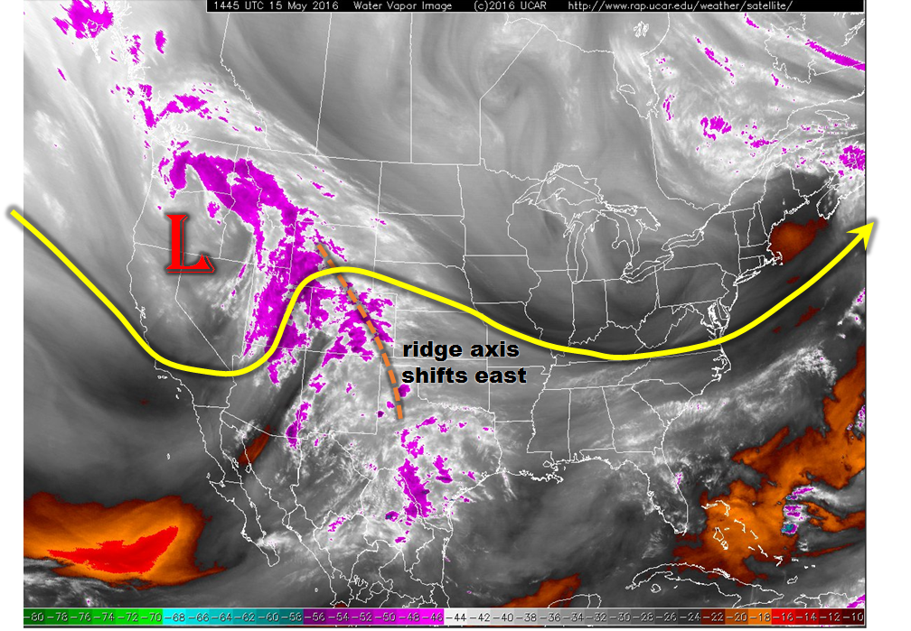
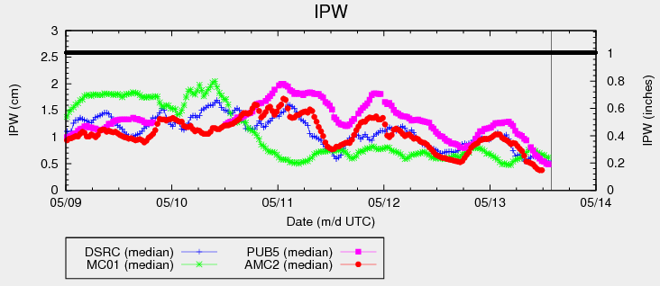
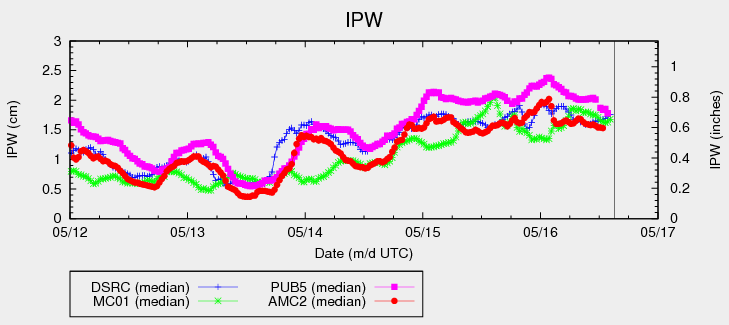
An upper-level low will continue to work its way eastward across the western US today, spreading mid-/upper-level support for scattered-to-widespread showers overhead. Plenty of moisture will continue to be pulled into Colorado at the same time, pushing precipitable water (IPW) values well above average for this time of year (see IPW graph below). Instability will be a mitigating factor across most of Colorado due to the extensive cloud cover and cool temperatures in many places.
The best moisture/instability will be present across the far Southeast Plains/Raton Ridge, bringing about the highest expected rain rates, thus the moderate threat for those locations. A few storms will become severe, with the main threats being large hail (1-1.5 inches/diameter), damaging winds (up to 55-70 mph), and an isolated tornado or two. Heavy rain will attend the strong/severe thunderstorms; rain rates will be mentioned in the zone-specific forecast discussions below.
Overall, showers will be widespread across most of Colorado this afternoon/evening, with thunderstorms more scattered in nature. Thunderstorms will be capable of producing moderate-to-heavy rainfall, but storm motions and meager instability (in most locations) are limiting factors on the flood threat. Thunderstorm activity will peak during the afternoon and early evening hours, with scattered showers/weak thunderstorms lingering into the overnight hours. Please see the zone-specific forecast discussions below for more details.
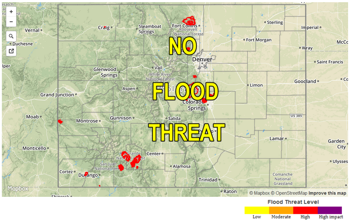
Today’s Flood Threat Map
For more information on today’s flood threat, see the map below (hover over threat areas for more details). For Zone-Specific forecasts, jump below the map.

Zone-Specific Forecasts
Urban Corridor (Arapahoe County and northward), and Northeast Plains:
Cloudy with scattered showers, and isolated afternoon/evening thunderstorms expected. The main threats from thunderstorms will be brief heavy rain and gusty winds. Maximum rain rates will be 0.4-0.8 inches/hour over the Northeast Plains, and 0.3-0.6 inches/hour over the Urban Corridor. High temperatures will be well below average for this time of year.
Timing: 11 AM – 8 PM, with lingering showers/weak thunderstorms through the overnight hours.
Urban Corridor (South of Arapahoe County), Southeast Plains, Palmer Ridge, and Raton Ridge:
Scattered showers and thunderstorms are expected. A few will become strong-to-severe over the Southeast Plains and Raton Ridge. Maximum rain rates vary:
Urban Corridor: 1.0-1.4 inches/hour
Palmer Ridge: 0.8-1.2 inches/hour
Southeast Plains and Raton Ridge: 1.8-2.2 inches/hour
Timing: Noon – 9 PM, with lingering showers/weak thunderstorms through the overnight hours
Front Range, Northwest Slope, Northern Mountains, Grand Valley, Central Mountains, Southwest Slope, San Juan Mountains, Southeast Mountains and San Luis Valley:
Widespread showers and thunderstorms are expected today. Thunderstorms will be capable of producing moderate-to-heavy rainfall, with stronger storms producing small hail and gusty winds up to 40-50 mph. Rain rates will vary:
Northern Mountains: 0.3-0.6 inches/hour
Front Range and Central Mountains: 0.8-1.2 inches/hour
Southeast Mountains: 1.4-1.8 inches/hour
Northwest Slope, Grand Valley, and Southwest Slope: 0.8-1.2 inches/hour
San Juan Mountains: 0.4-0.7 inches/hour
San Luis Valley: 0.2-0.5 inches/hour
Timing: Current – 8 PM, with isolated lingering showers into the early morning hours