Issue Date: Sunday May 15th, 2016
Issue Time: 10:25 AM MDT
— No Flood Threat Today
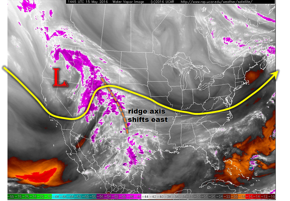
Today’s water vapor imagery, shown below, indicates that the weak upper-level high pressure system has moved slightly eastward and is no longer much of a presence. Meanwhile, a seasonably strong low-pressure center has entered the west coast and is centered just west of the Great Basin. As this system moves slowly eastward, it will support shower and some thunderstorm activity across most of Colorado.
In terms of the heavy rainfall potential,
• the atmosphere’s dynamics are certainly more conducive than yesterday
• precipitable water values range between 0.6 and 0.8 inches, which is quite a bit higher than normal for this time of year (Denver’s normal is about 0.45 for May 15th)
• morning sounding at Grand Junction (as well as Salt Lake City which is closer to the low center), most of the moisture is well above the surface. Instead, the low-level soundings favor more of a strong wind threat than a rain threat
• instability is limited, with most high-resolution probabilistic guidance such as the NCAR ensemble showing rather small chances of exceeding 500 J/kg
• storm motion will be in the 30-40 mph range, which is fast enough to limit heavy rainfall in any given location.
In all, today will see significantly more rainfall than yesterday, both in terms of coverage and intensity. However, 1-hr and 3-hr rainfall intensities are expected to stay below flood threat levels across the state. Thus, no flood threat is expected today.
Today’s Flood Threat Map
For more information on today’s flood threat, see the map below (hover over threat areas for more details). For Zone-Specific forecasts, jump below the map.

Zone-Specific Forecasts
Urban Corridor, Front Range, Northeast Plains:
Overcast early with a few breaks in the clouds by early afternoon. Isolated to scattered showers and thunderstorms will occur from early afternoon to early evening. Max hourly rain rates up to 0.5 inches can be expected, with max 3-hourly rates up to 0.75 inches. No flood threat is expected today.
Prime-time: 1PM to 7PM
Central Mountains, Southwest Slope, Raton Ridge, Southeast Mountains, San Luis Valley, San Juan Mountains, Palmer Ridge and Southeast Plains:
Broken clouds early with scattered showers and thunderstorms developing by early afternoon and lasting into the early evening. Max hourly rain rates up to 0.7 inches are possible with max 3-hourly rain rates up to 0.9 inches. The strongest thunderstorms will be capable of producing hail up to 0.5 inches and gusty winds up to 60mph especially in the southern part of the area. No flood threat is expected today.
Prime-time: 12PM to 7PM
Grand Valley, Northern Mountains and Northwest Slope:
Broken clouds with scattered showers and a weak thunderstorm or two possible throughout the day into the late evening hours. Max hourly rain rates up to 0.5 inches will be possible. Some locations could see close to 1 inch of rainfall over the 24-hour period ending tomorrow morning. The snow level will be above 12,000 feet during the day, falling to about 9,500 feet after sunset.
Prime-time: 11AM to 9PM