FTB 05-20-2016: Uptick in Temperatures, Downtick in Thunderstorm Coverage

Issue Date: 5/20/2016
Issue Time: 10:02 AM

NO FLOOD THREAT IS FORECAST.

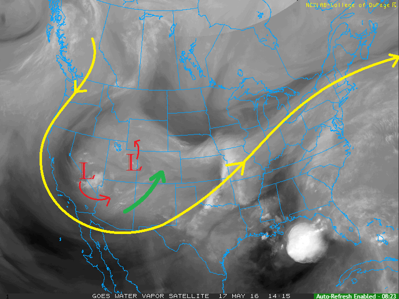
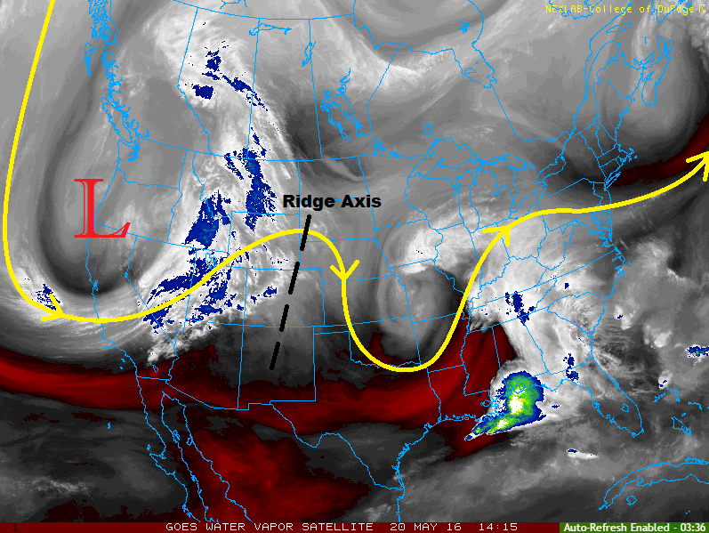
The water vapor image below provides a nice overview of the big players aloft in our forecast today. The strong upper-level low (red “L”) will continue digging along the West Coast, dipping down into the Desert Southwest by tonight. Meanwhile, the upper-level ridge that move into Colorado yesterday will continue to shift eastward, with the ridge axis sitting overtop western Kansas by later tonight. The ridging will allow the warming trend to continue across Colorado, while suppressing most thunderstorm activity.

Even though the upper-level ridge will try its best to suppress activity, it will not be entirely successful. Orographic effects will work with daytime heating to produce isolated showers/thunderstorms over the mountains, mainly along the Continental Divide and San Juan Mountains. A few will develop over the Front Range and Southeast Mountains, moving over adjacent lower elevations of the Urban Corridor, Palmer Ridge, and Southeast Plains.

WV_20160520

Further east, the storm threat is more conditional. Due to warming aloft, much of the environment will remain capped off across the Northeast Plains, Palmer Ridge, and Southeast Plains regions. A couple isolated thunderstorms will likely break the cap, but will remain high-based due to fairly dry lower-levels. The greatest threat from these storms will be gusty winds and lightning. For more information regarding timing and rain rates, please see the zone-specific discussions below.

Today’s Flood Threat Map

For more information on today’s flood threat, see the map below (hover over threat areas for more details). For Zone-Specific forecasts, jump below the map.

Flood Threat Legend

Zone-Specific Forecasts

Urban Corridor, Northeast Plains, Southeast Plains, Palmer Ridge, and Raton Ridge:

Isolated showers/thunderstorms are expected, mainly along and near the higher terrain. A couple of isolated thunderstorms are possible further east, dependent on whether or not they can break through the cap. The main threats with any thunderstorms will be gusty winds and lightning. Maximum rain rates vary:

Urban Corridor: 0.25-0.5 inches/hour
Northeast Plains and Palmer Ridge: 0.3-0.6 inches/hour
Southeast Plains: 0.25-0.5 inches/hour
Raton Ridge: 0.15-0.25 inches/hour

Timing: Noon – 10 PM

Front Range, Southeast Mountains, Northern Mountains, Northwest Slope, Central Mountains, Grand Valley, Southwest Slope, San Juan Mountains, and San Luis Valley:

Isolated showers and thunderstorms are expected to develop this afternoon and evening, with the best chances (relatively speaking) over the Continental Divide and San Juan Mountains. The main threats from any thunderstorm activity will be gusty winds and lightning. Maximum rain rates vary:

Front Range and Northern Mountains: 0.2-0.4 inches/hour
Central Mountains, Southeast Mountains, and San Juan Mountains: 0.1-0.3 inches/hour
Northwest Slope, Grand Valley, Southwest Slope, and San Luis Valley: 0.05-0.2 inches/hour

Timing: Noon – 9 PM, with a couple isolated showers/weak thunderstorms lingering until midnight.

FTB 05-19-2016: Transient Ridge Overtop Colorado

Issue Date: 5/19/2016
Issue Time: 9:30 AM

NO FLOOD THREAT IS FORECAST.

An upper-level ridge will move into Colorado today in advance of the next upper-level low deepening along the West Coast. The ridging will help dry out the atmosphere just a bit, as well as suppress some afternoon/evening convection. Although it won’t be a completely dry day, the ridge will provide warmer temperatures than the last few days, getting high temperatures almost back to average for this time of year.

IPW_20160519

The best coverage of showers and thunderstorms will be over the higher terrain and high valleys, with a few spilling over the adjacent lower elevations. IPW values (see chart above) are about average for the date, so heavy rain rates reaching flash flood threat thresholds is not a concern today. Expect most of the activity to diminish just after sunset with the loss of daytime heating. Please see the zone-specific discussions below for more details on timing and rain rates.

Today’s Flood Threat Map

For more information on today’s flood threat, see the map below (hover over threat areas for more details). For Zone-Specific forecasts, jump below the map.

Flood Threat Legend

Zone-Specific Forecasts

Urban Corridor, Northeast Plains, Southeast Plains, Palmer Ridge, and Raton Ridge:

Isolated-to-widely scattered showers/thunderstorms will spill over the higher terrain into adjacent lower elevations today. Terrain influences of the Raton Ridge, Palmer Ridge, and Cheyenne Ridge may have just enough “oomph” to produce an isolated thunderstorm or two today, but not much in the way of rainfall is expected. Maximum rain rates will vary:

Urban Corridor, northeast Plains, Palmer Ridge, and Southeast Plains: 0.25-0.5 inches/hour
Raton Ridge: 0.4-0.7 inches/hour

Timing: Noon – 9 PM

Front Range, Southeast Mountains, Northern Mountains, Northwest Slope, Central Mountains, Grand Valley, Southwest Slope, San Juan Mountains, and San Luis Valley:

Widely scattered showers/thunderstorms expected today, mainly over the higher terrain and high valleys. Moisture is about average for this time of year, so rain rates will not reach flash flood threat criteria. Maximum rain rates vary:

Front Range, Northern Mountains, Central Mountains, and Southeast Mountains: 0.4-0.7 inches/hour
Northwest Slope: 0.2-0.4 inches/hour
Grand Valley: 0.3-0.6 inches/hour
Southwest Slope, San Juan Mountains, and San Luis Valley: 0.5-0.8 inches/hour

Timing: 11 AM – 9 PM

FTB 05-18-2016: Persistent Upper-Level Low Keeps Colorado Cool/Unsettled

Issue Date: 5/18/2016
Issue Time: 9:45 AM

A LOW FLOOD THREAT IS FORECAST TODAY FOR PORTIONS OF THE CACHE LA POUDRE RIVER AND SOUTH PLATTE RIVER.

The upper-level low/trough that we have been discussing for a few days now will continue its slow, eastward progression during this period. This will keep temperatures cool (albeit slightly warmer than yesterday) while upper-level support brings about another day of showers and thunderstorms. Locations along and west of the Continental Divide will be favored for the greatest coverage of precipitation today, especially south of I-70. Elevations above 10,000 feet will continue to see precipitation fall as snow, bringing a few additional inches to the peaks. Sufficient moisture remains across the state, as noted in the IPW chart below, but instability will be fairly meager. Rain rates will not meet flash flood criteria, thus no flood threat is warranted.

IPW_20160518

East of the Continental Divide, coverage will be less. Expect widely scattered showers/weak thunderstorms across the Front Range/Southeast Mountains and adjacent foothills/plains, while areas further east stay mainly dry with only isolated showers. Rain rates in these regions will remain below flash flood threat thresholds, so no flood threat will be issued. For more details on timing/rain rates, please see the zone-specific forecast discussions below.

Today’s Flood Threat Map

For more information on today’s flood threat, see the map below (hover over threat areas for more details). For Zone-Specific forecasts, jump below the map.

Flood Threat Legend

Zone-Specific Forecasts

Front Range, Southeast Mountains, Urban Corridor, Northeast Plains, Southeast Plains, Palmer Ridge, and Raton Ridge:

Widely scattered showers/weak thunderstorms over the Front Range/Southeast Mountains and adjacent portions of the Urban Corridor, Palmer Ridge, Raton Ridge, and Southeast Plains. Further east, isolated showers will be about all the atmosphere can muster. Maximum rain rates will vary, with mountain/foothills locations at 0.3-0.6 inches/hour, and lower elevations at 0.25-0.5 inches/hour.

Timing: 11 AM – 9 PM, with only a few showers lingering over the Southeast Mountains into the early morning hours

Northern Mountains, Northwest Slope, Central Mountains, Grand Valley, Southwest Slope, San Juan Mountains, and San Luis Valley:

Scattered showers/weak thunderstorms expected, with the best coverage south of I-70. As noted above, elevations above 10,000 feet will see precipitation fall as snow; some of the higher peaks of the San Juan Mountains and Southwest Slope region will pick up 4-8 inches.

Elsewhere, rain rates are not expected to reach flash flood thresholds. Max rain rates will be 0.5-0.8 inches/hour. Persistent rainfall in a few locations south of I-70 will bring 0.5-1.0 total inches of rain.

Timing: 11 AM – 9 PM, with a few isolated showers continuing into the early morning hours.

FTB 05-17-2016: Cool and Unsettled Pattern Continues

Issue Date: 5/17/2016
Issue Time: 10:05 AM

A LOW FLOOD THREAT IS FORECAST FOR PORTIONS OF THE SAN JUAN MOUNTAINS, SOUTHWEST SLOPE, GRAND VALLEY, AND NORTHWEST SLOPE.

Another cool and unsettled day is in store for Colorado as the upper-level trough continues to sit across the western US. Two distinct upper-level low circulations are noted in the water vapor imagery (red “L), along with their expected movement today (red arrows). The placement of the circulations will continue to stream moisture (green arrow) from the south/southwest, keeping precipitable water values above average for the date. Additionally, diffluent flow/divergence aloft will provide broad scale support for scattered showers/thunderstorms, mainly over the High Country and the adjacent valleys. Thunderstorms will be capable of brief heavy rainfall and gusty winds, as well as heavy snowfall above 10,000 feet.

WV_20160517

Upslope flow over eastern Colorado will keep isolated shower chances in place for the plains regions, with slightly more coverage over and near the foothills/Urban Corridor. Not much in the way of heavy rain is expected for areas east of the mountains as the atmosphere will simply be too stable. Expect precipitation to be more of a light shower/drizzle variety. For more information regarding timing/rain rates, please see the zone-specific discussions below.

Today’s Flood Threat Map

For more information on today’s flood threat, see the map below (hover over threat areas for more details). For Zone-Specific forecasts, jump below the map.

Flood Threat Legend

Zone-Specific Forecasts

Urban Corridor, Northeast Plains, Southeast Plains, Palmer Ridge, and Raton Ridge:

Another cool day is in store, with isolated-to-scattered precipitation expected. The atmosphere will remain mainly stable, keeping rain rates low. Maximum rain rates will be 0.1-0.3 inches/hour. Precipitation will be of the light shower/drizzle variety as upslope flow does the heavy lifting. Due to this, the best coverage of showers will be for areas adjacent/near the higher terrain.

Timing: Current – 9 PM, with isolated showers lingering into tomorrow morning

Front Range, Northern Mountains, Central Mountains, Southeast Mountains and San Luis Valley:

Scattered showers and weak thunderstorms expected today, resulting in mainly light rain and gusty winds. Maximum rain rates will vary:

Front Range and Southeast Mountains: 0.2-0.4 inches/hour
Northern Mountains and Central Mountains: 0.4-0.7 inches/hour
San Luis Valley: 0.5-0.8 inches/hour

Timing: 11 AM – 8 PM, with a few lingering showers into the early morning hours

Northwest Slope, Grand Valley, Southwest Slope, and San Juan Mountains:

Scattered showers and embedded thunderstorms expected. Rainfall from showers will be light, but thunderstorms will have the potential to produce brief, heavy rainfall at 1.0-1.4 inches/hour. The low-end low flood threat has been issued as a result of the potential for brief heavy rain to fall on top of saturated soil. The main concerns will be low-lying areas along streams/rivers and street ponding in poorly drained areas. Snow will fall above 10,000 feet, and may be heavy at times. Travel on mountain passes will see minimal impact, however, as roads will still be warm enough to melt the snow.

Timing: Isolated showers are ongoing, coverage of both showers and thunderstorms will increase through the afternoon/early evening. Activity will diminish after sunset, but expect isolated showers to continue into the early morning hours, mainly south of I-70.