Issue Date: 5/19/2016
Issue Time: 9:30 AM
NO FLOOD THREAT IS FORECAST.
An upper-level ridge will move into Colorado today in advance of the next upper-level low deepening along the West Coast. The ridging will help dry out the atmosphere just a bit, as well as suppress some afternoon/evening convection. Although it won’t be a completely dry day, the ridge will provide warmer temperatures than the last few days, getting high temperatures almost back to average for this time of year.
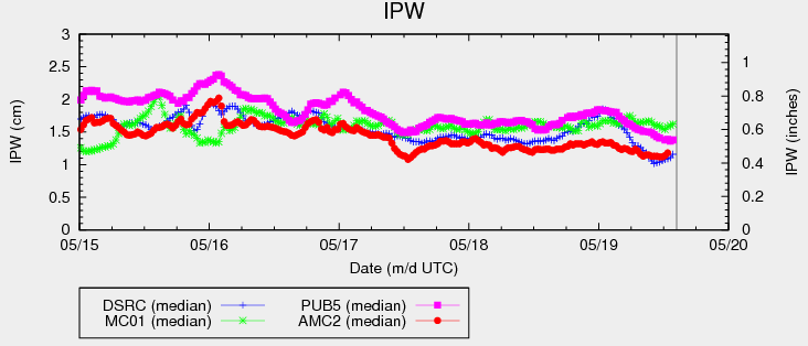
The best coverage of showers and thunderstorms will be over the higher terrain and high valleys, with a few spilling over the adjacent lower elevations. IPW values (see chart above) are about average for the date, so heavy rain rates reaching flash flood threat thresholds is not a concern today. Expect most of the activity to diminish just after sunset with the loss of daytime heating. Please see the zone-specific discussions below for more details on timing and rain rates.
Today’s Flood Threat Map
For more information on today’s flood threat, see the map below (hover over threat areas for more details). For Zone-Specific forecasts, jump below the map.

Zone-Specific Forecasts
Urban Corridor, Northeast Plains, Southeast Plains, Palmer Ridge, and Raton Ridge:
Isolated-to-widely scattered showers/thunderstorms will spill over the higher terrain into adjacent lower elevations today. Terrain influences of the Raton Ridge, Palmer Ridge, and Cheyenne Ridge may have just enough “oomph” to produce an isolated thunderstorm or two today, but not much in the way of rainfall is expected. Maximum rain rates will vary:
Urban Corridor, northeast Plains, Palmer Ridge, and Southeast Plains: 0.25-0.5 inches/hour
Raton Ridge: 0.4-0.7 inches/hour
Timing: Noon – 9 PM
Front Range, Southeast Mountains, Northern Mountains, Northwest Slope, Central Mountains, Grand Valley, Southwest Slope, San Juan Mountains, and San Luis Valley:
Widely scattered showers/thunderstorms expected today, mainly over the higher terrain and high valleys. Moisture is about average for this time of year, so rain rates will not reach flash flood threat criteria. Maximum rain rates vary:
Front Range, Northern Mountains, Central Mountains, and Southeast Mountains: 0.4-0.7 inches/hour
Northwest Slope: 0.2-0.4 inches/hour
Grand Valley: 0.3-0.6 inches/hour
Southwest Slope, San Juan Mountains, and San Luis Valley: 0.5-0.8 inches/hour
Timing: 11 AM – 9 PM