Issue Date: 6/5/2016
Issue Time: 9:31 AM
A LOW FLOOD THREAT IS FORECAST FOR PORTIONS OF THE RATON RIDGE, SOUTHEAST MOUNTAINS, URBAN CORRIDOR, SOUTHEAST PLAINS, FRONT RANGE, CENTRAL MOUNTAINS, AND PALMER RIDGE.
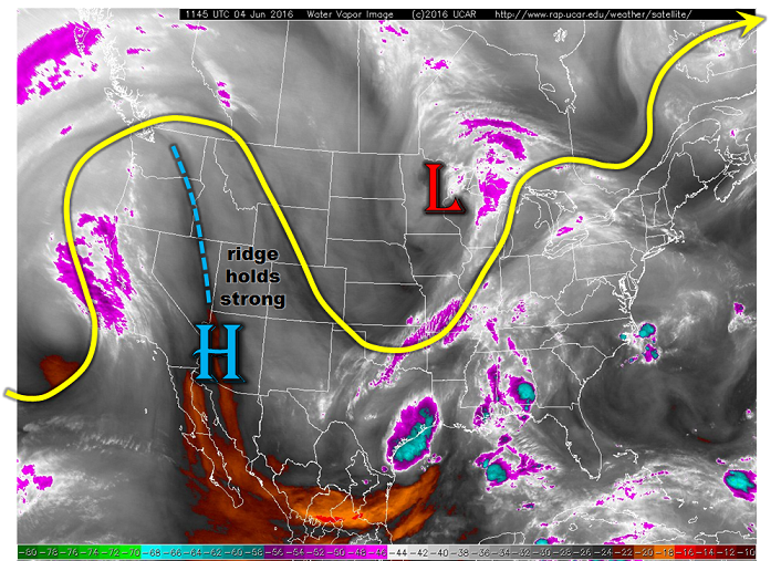
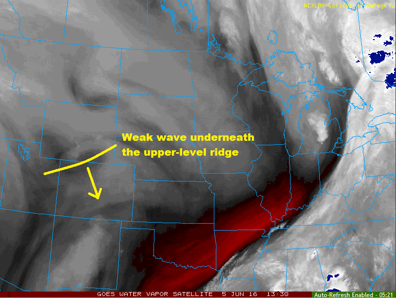
The upper-level ridge that has been in control of the forecast will remain over the area, albeit a slightly dampened version due to an upper-level low spinning over northern CA/southern OR. Underneath the ridge resides a weak wave (disturbance), which will rotate across Colorado within the northwest flow aloft. This wave (highlighted in the water vapor image below) will kick off an increase in showers and thunderstorms this afternoon/evening. Scattered storms will occur across the Southeast Mountains, San Juan Mountains, and Raton Ridge, and a few will move over the adjacent lower elevations/plains due to more westerly flow aloft. Periods of moderate-to-heavy rainfall will occur under the stronger storms, especially over the Southeast Mountains and Raton Ridge, as well as the adjacent Southeast Plains. A couple of storms may reach severe thresholds for hail and gusty winds.
Isolated-to-widely scattered showers/thunderstorms are expected over the Northern Mountains, Central Mountains, Southwest Slope, Front Range, Urban Corridor, Palmer Ridge, and Northeast Plains regions. Brief heavy rainfall will occur underneath the stronger storms in the areas highlighted by the low flood threat.
Otherwise, the weather story will be the heat again today, especially across western Colorado where high temperatures will be 10-15 degrees above average. A few locations in the Colorado River valley near the CO/WY border will push into the middle 90s. For eastern Colorado, temperatures will be warm, but not to the same extent as western Colorado. High temperatures will be in the 70s and 80s, with the warmest spots in the Arkansas River valley.
For more information regarding timing and rain rates of today’s thunderstorms, please see the zone-specific discussions below.
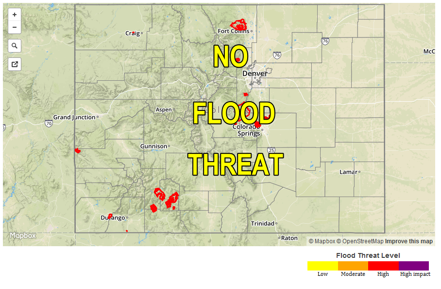
Today’s Flood Threat Map
For more information on today’s flood threat, see the map below (hover over threat areas for more details). For Zone-Specific forecasts, jump below the map.

Zone-Specific Forecasts
Northeast Plains, Urban Corridor, and Palmer Ridge:
Isolated-to-widely scattered showers/thunderstorms, with the coverage decreasing from the west to east. The far Northeast Plains will remain dry and underneath mostly sunny skies. Brief periods of moderate-to-heavy rainfall will occur under the stronger storms, mainly over the Palmer Ridge and southern portions of the Urban Corridor. Maximum rain rates vary:
Northeast Plains: 0.8-1.2 inches/hour
Urban Corridor: 1.0-1.5 inches/hour
Palmer Ridge: 1.0-1.6 inches/hour
Timing: 1 PM – 10 PM
Central Mountains, Northern Mountains, and Front Range:
Isolated-to-widely scattered showers/thunderstorms expected. Storms over the Northern Mountains will remain high-based, producing more gusty winds and lightning than rain. For the Front Range and Central Mountains, storms will produce a bit more rain, and southern extents have been included in the low food threat area. Maximum rain rates will be:
Northern Mountains: 0.15-0.25 inches/hour
Central Mountains: 0.7-1.1 inches/hour
Front Range: 0.6-1.0 inches/hour
Timing: 1 PM – 9 PM
Raton Ridge, Southeast Plains, San Juan Mountains, Southeast Mountains, and San Luis Valley:
Scattered showers and thunderstorms expected, and a few will become strong-to-severe. The best chance at heavy rain will be across the Southeast Mountains, Raton Ridge, and western portions of the Southeast Plains. These areas have been included in the low flood threat. Maximum rain rates will be:
Raton Ridge, Southeast Plains, and Southeast Mountains: 1.8-2.2 inches/hour
San Juan Mountains: 0.6-0.8 inches/hour
San Luis Valley: 1.0-1.8 inches/hour
Timing: 1 PM – Midnight
Northwest Slope, Grand Valley and Southwest Slope:
Mostly sunny and hot will be the main weather story today, with only a couple high-based showers/weak thunderstorms possible over the higher terrain. Any storm activity will produce more gusty winds and lightning than rain. Any storm activity will diminish after peak heating, coming to an end during the late evening.