Issue Date: Sunday, July 3rd, 2016
Issue Time: 10:15AM MDT
— LOW flood threat for Palmer Ridge, Southeast Plains, Raton Ridge, Southeast Mountains and Grand Valley
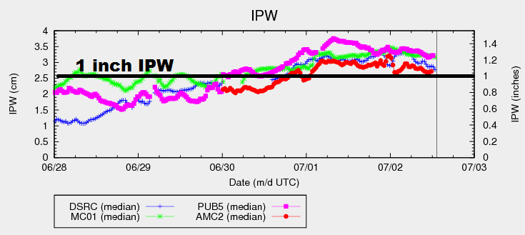
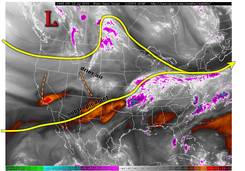
A rather complicated weather map is found this morning across the western United States, as shown in the water vapor image below. The large-scale features include a low-pressure center across British Columbia and a distinct subtropical jet stream racing across the southern Rocky Mountain states. The latter feature will affect Colorado today as it drags a disturbance over the western part of the state eastward. Notable mid-level cooling was observed over the last 24-hours statewide and some more cooling today will help to create afternoon instability. Moisture continues to be abundant this morning with Precipitable Water (PW) values of about 1 inch, with pockets of higher values, across the state. However, this will be countered by significant drying being advected in from the north. For example, the Riverton (WY) sounding’s PW dropped from 0.74 to 0.43 inches over the past 24 hours. This air will affect northeast CO today, eliminating the heavy rainfall threat in that region.
Overall, expect a quick development of high elevation shower and thunderstorm activity to spread quickly into the lower elevations. Heavy rainfall will be possible across parts of the western slope and southeast parts of the state. Faster storm motion compared to past days implies that only a Low flood threat is warranted today for isolated flash flooding.
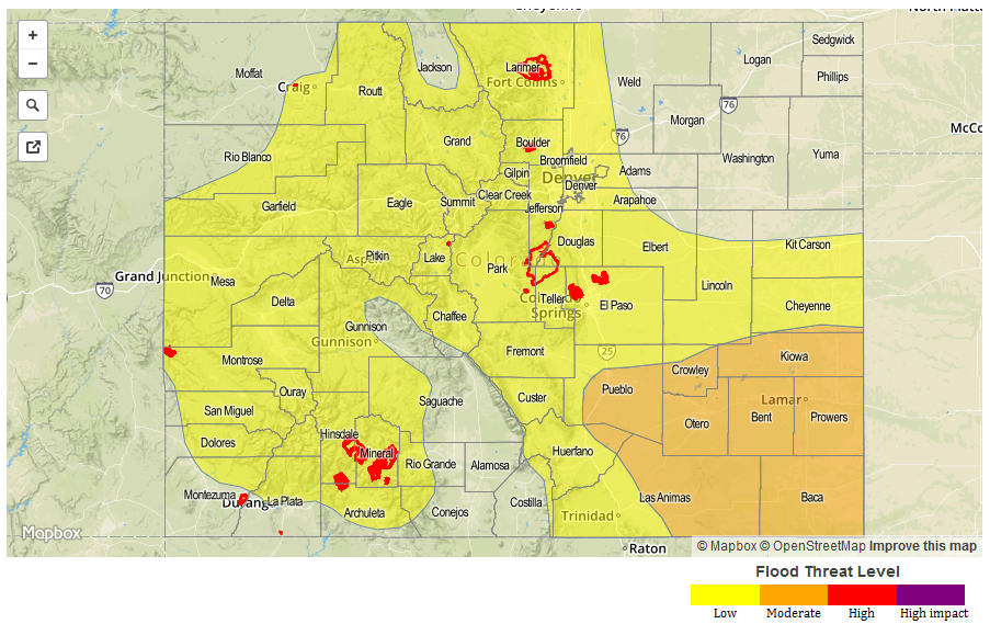
Today’s Flood Threat Map
For more information on today’s flood threat, see the map below (hover over threat areas for more details). For Zone-Specific forecasts, scroll below the map.

Zone-Specific Forecasts:
Southeast Mountains, Raton Ridge, Palmer Ridge, Southeast Plains:
Partly cloudy early, the scattered to widespread showers and thunderstorms developing around noon. Storms will first develop over the higher terrain, then spread eastward. Maximum 1-hour rain rates up to 1.8 inches will be possible, leading to isolated field and roadway flooding. Mud flows and debris slides will be possible over higher terrain. Small hail, up to 0.5 inches in diameter, will be possible in the strongest storm cells. Activity will quickly diminish after sunset. A Low flood threat has been posted for parts of the area.
Primetime: 1pm through 9pm
San Juan Mountains, San Luis Valley, Northern Mountains, Grand Valley, Northwest Slope, Southwest Slope, Central Mountains:
Partly cloudy early with scattered thunderstorms and high-elevation showers developing by noon. Max 30-minute rain rate up to 0.8 inches and hourly rain rate up to 1.3 inches is possible. Isolated flash flooding is possible in association with the strongest storms cells. Hail up to 0.5 inches is also possible. Activity will diminish quickly after sunset. A Low flood threat has been posted for parts of the area.
Primetime: 12pm through 8pm
Northeast Plains, Urban Corridor, Front Range:
Mostly sunny early, then isolated to scattered thunderstorms developing by mid-afternoon. Highest coverage will be across southern parts of the area. Maximum 1-hour rainfall up to 0.8 inches. Activity will quickly diminish by early evening. Flooding is not expected.
Primetime: 2pm to 7pm