Issue Date: 7/2/2016
Issue Time: 9:13 AM
A MODERATE FLOOD THREAT IS ISSUED FOR PORTIONS OF THE SOUTHEAST PLAINS AND RATON RIDGE.
A LOW FLOOD THREAT IS ISSUED FOR SURROUNDING AREAS, INCLUDING PORTIONS OF THE NORTHEAST PLAINS, PALMER RIDGE, URBAN CORRIDOR, FRONT RANGE, SOUTHEAST MOUNTAINS, NORTHERN MOUNTAINS, CENTRAL MOUNTAINS, SAN JUAN MOUNTAINS, SOUTHWEST SLOPE, GRAND VALLEY, AND NORTHWEST SLOPE.
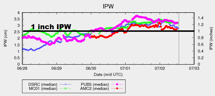
Abundant moisture still sits across the state, evidenced by the IPW chart below. All 4 of the normal reporting stations (Boulder, Grand Junction, Pueblo, and Schriever AFB) are all above 1 inch this morning. This moisture will stick around throughout the afternoon and into the evening before drier air begins to move into Colorado from west to east. This means another day of scattered-to-widespread showers/thunderstorms over the High Country, with scattered activity over the lower elevations of eastern Colorado. The one exception will be Northeast Plains, east Highway 71 and north of Highway 36, where only isolated coverage of is expected.
Instability will be less than yesterday across most areas, and maximum rain rates will be down accordingly. Exceptions to this include portions of the High Country where sunlight is allowed to peek through the clouds and over the Southeast Plains/Raton Ridge where a small dry slot aloft has resulted in clear skies and allowing sunshine to warm the low-levels. The relative maximum in instability over the Southeast Plains/Raton Ridge means the strongest storms of the day will occur over these regions, producing the heaviest rainfall. A moderate flood threat has been issued for the Southeast Plains for this reason, plus the consideration of the last few days of heavy rainfall.
Today’s Flood Threat Map
For more information on today’s flood threat, see the map below (hover over threat areas for more details). For Zone-Specific forecasts, jump below the map.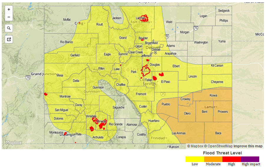
Zone-Specific Forecasts
Front Range, Southeast Mountains, Urban Corridor, and Palmer Ridge:
Scattered showers/thunderstorms expected today/tonight, ending for most locations by 10 PM. Instability will be less than yesterday, and rain rates will be down accordingly. There is still a risk for heavy rain underneath a stronger thunderstorm due to the shear amount of moisture available. Thus, the low flood threat. Maximum rain rates are as follows:
Front Range and Southeast Mountains: 1.0-1.4 inches/hour
Urban Corridor: 1.0-1.6 inches/hour
Palmer Ridge: 1.2-1.8 inches/hour
Timing: A few showers are ongoing, coverage/intensity will increase through the afternoon/early evening, ending by, or just after, 10 PM.
Northeast Plains:
Isolated-to-scattered showers/thunderstorms expected, mainly west of Highway 71 and south of Highway 36. A couple isolated showers/storms may develop in the far northeast corner, but probabilities are low. Maximum rain rates will be 0.8-1.4 inches/hour.
Timing: Current – 10 PM
Raton Ridge and Southeast Plains:
Scattered showers/thunderstorms expected, a few will be strong/severe. The main threats from stronger thunderstorms will be strong wind, hail, lightning, and heavy rain. Maximum rain rates will be 1.8-2.5 inches/hour for the Raton Ridge and 2.5-3.0 inches/hour for the Southeast Plains.
Timing: 11 AM – 2 AM over the Southeast Plains, 11 AM – 10 PM for the Raton Ridge
Northern Mountains, Northwest Slope, Grand Valley, Central Mountains, San Juan Mountains, Southwest Slope, and San Luis Valley:
Scattered-to-widespread showers/thunderstorms expected again today and into this evening, ending from west to east as drier air works in. Pockets of stronger instability will develop where sunshine is allowed to peak through, so there is a threat of heavy rain once again today. The threat is less than previous days, and only a low threat will be issued today. Maximum rain rates are as follows:
Northern Mountains, Central Mountains, San Juan Mountains, and Grand Valley: 0.8-1.4 inches/hour
Northwest Slope: 0.6-1.0 inches/hour
Southwest Slope: 0.8-1.2 inches/hour
Timing: Ongoing – 10 PM, ending from west to east