Issue Date: 7/1/2016
Issue Time: 10:11 AM
2:30 PM UPDATE SUMMARY: After monitoring observational trends, and consulting with updated model guidance, the High Flood Threat has been extended southward. Additionally, the Moderate Flood Threat has been extended slightly to the south and east, now including more of the Arkansas River Valley.
DISCUSSION: The development of scattered-to-widespread showers/thunderstorms is underway, with a few stronger storms being noted across the eastern mountains/I-25 corridor. Moisture continues to be abundant, with all four of the normal reporting stations (Grand Junction, Boulder, Pueblo, Schriever AFB) showing IPW values greater than 1 inches, with Grand Junction, Boulder, and Pueblo all above 1.2 inches.
A Denver cyclone has indeed developed, setting up over northern Douglas and Elbert counties. The High Flood Threat and Moderate Flood Threat areas have both been extended to the south and east as those areas have developed the greatest instability; sunshine has warmed temperatures with surface dewpoints in the low 60s. Aside from these changes, the previous discussion remains valid.
A HIGH FLOOD THREAT IS ISSUED FOR PORTIONS OF THE URBAN CORRIDOR, FRONT RANGE, AND PALMER RIDGE.
A MODERATE FLOOD THREAT IS ISSUED FOR SURROUNDING AREAS, INCLUDING PORTIONS OF THE NORTHEAST PLAINS AND SOUTHEAST PLAINS.
A MODERATE FLOOD THREAT IS ALSO ISSUED FOR PORTIONS OF THE SOUTHWEST SLOPE, SAN JUAN MOUNTAINS, AND GRAND VALLEY.
A LOW FLOOD THREAT IS ISSUED FOR SURROUNDING AREAS, INCLUDING PORTIONS OF THE NORTHERN MOUNTAINS, NORTHWEST SLOPE, CENTRAL MOUNTAINS, SOUTHEAST MOUNTAINS, AND RATON RIDGE.
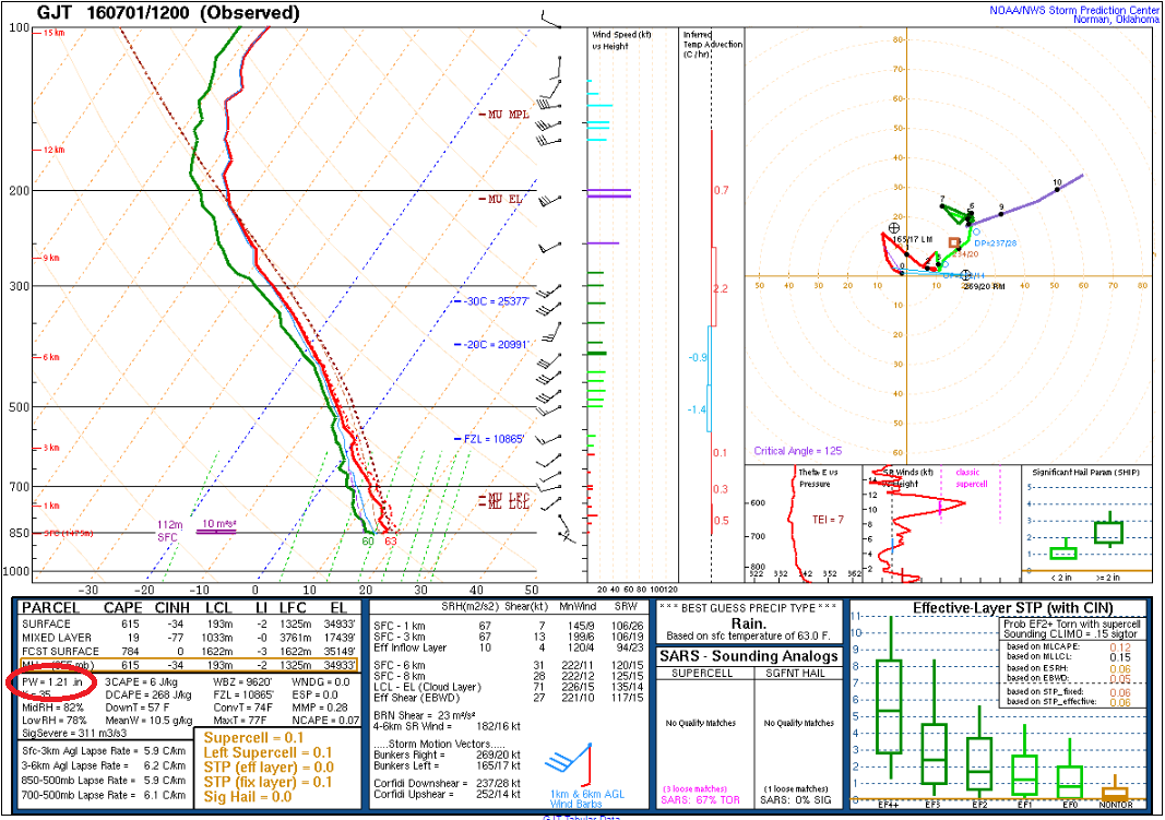
Moisture is abundant across Colorado this morning, and this morning’s soundings (below, click to enlarge) show this well. Precipitable water is anomalously high, setting 12Z records for the date at both Denver (1.17 inches) and Grand Junction (1.21 inches). Dewpoints across most of the state currently reside in the 50s and 60s, with 40s along the Continental Divide. This high moisture content, coupled with a warm layer depth of about 3 km, will allow for efficient rainfall processes. Heavy rain is a good bet underneath thunderstorms.

The heavy rain threat will exist across nearly all of Colorado, but of particular concern are portions of the Front Range, Urban Corridor, and Palmer Ridge. There is potential for a Denver convergence zone to develop today due to the southeasterly low-level winds; if it develops, this will be a focus for the development of stronger storms. Urban areas are also a heightened flood risk due to the amount of impervious surfaces and their associated drainage issues.
In an effort to be thorough, it is important to point out that there is some uncertainty regarding the evolution of today’s risk. Instability will be a limiting factor today, especially with the expansive cloud cover across the state. Meanwhile, a mid-level disturbance will work to counteract the lack of daytime heating by transporting cooler temperatures aloft over Colorado. There are quite a few competing factors in this period’s forecast. After consulting all of the above factors, the flood threats that have been issued are warranted.
In addition to the heavy rain threat, a few strong/severe thunderstorms are likely across eastern Colorado, mainly east of I-25. Threats from these storms will be strong/damaging winds, hail (up to 1.5 inches in diameter), heavy rain, and lightning. An isolated tornado cannot be ruled out.
For more details regarding timing, rain rates, etc., please see the zone-specific discussions below. Our team of meteorologists will be monitoring today’s unfolding situation, and will post a forecast update at 3 PM. You can stay tuned by checking back in, and/or following our Twitter account (@COFloodUpdates).
Today’s Flood Threat Map
For more information on today’s flood threat, see the map below (hover over threat areas for more details). For Zone-Specific forecasts, jump below the map.

Zone-Specific Forecasts
Front Range, Urban Corridor, Northeast Plains, Palmer Ridge, and Southeast Plains:
Widespread showers and thunderstorms are expected throughout today and into tonight, generally ending from west to east. Heavy rain is a good bet underneath thunderstorms, and the potential for the development of a Denver convergence zone is ringing the High Flood Threat bells for portions of the Front Range, Urban Corridor, and Palmer Ridge. Urban street flooding is the highest concern, especially in intersections and poor drainage areas. Burn scars will need to be monitored for bursts of very heavy rain, especially the Waldo Canyon burn scar. The moderate flood threat extends well east of the high threat, encompassing plains areas that have received heavy rainfall over the past several days. Maximum rain rates are as follows:
Front Range: 1.5-2.2 inches/hour
Urban Corridor and Palmer Ridge: 2.0-3.0 inches/hour
Northeast Plains and Southeast Plains: 2.5-3.0 inches/hour
Timing: 11 AM – 1 AM, with isolated showers/storms over eastern areas lingering into the morning hours.
Southeast Mountains and Raton Ridge:
Scattered showers and thunderstorms are expected throughout today and tonight, with a couple isolated showers continuing into tomorrow morning. These areas are the most distant (relatively speaking) from the best mid-level support, so rain rates will be a bit lower than other locations. Maximum rain rates are:
Southeast Mountains: 0.8-1.2 inches/hour
Raton Ridge: 0.9-1.4 inches/hour
Timing: 11 AM – 11 PM, with a couple isolated showers lingering into tomorrow morning.
Northwest Slope, Northern Mountains, Central Mountains, San Juan Mountains, Southwest Slope, Grand Valley, and San Luis Valley:
Isolated-to-scattered showers/storms are currently ongoing across the area, mainly along and south of the I-70 corridor. Coverage will increase through the afternoon as daytime temperatures warm and a mid-level disturbance pivots in from the southwest. The areas that will receive the best support from this disturbance are included in the moderate flood threat area. In areas where rain has fallen recently, runoff will be enhanced, and that is an added concern today.
Generally speaking, with the amount of moisture available, an expansive low flood threat is warranted. Scattered showers and storms will continue into tomorrow morning, mainly over the higher terrain. Maximum rain rates are as follows:
Northwest Slope, Northern Mountains, Central Mountains, and San Luis Valley: 0.8-1.2 inches/hour
Grand Valley, Southwest Slope, and San Juan Mountains: 0.9-1.4 inches/hour
Timing: 11 AM – 1 AM, with lingering showers/storms into the morning hours tomorrow