FTB 07-07-2016: Pleasant Summer Day Ahead

Issue Date: 7/7/2016
Issue Time: 9:21 AM

NO FLOOD THREAT IS FORECAST.

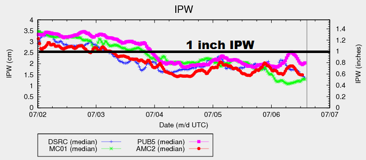
Moisture values fell significantly overnight and this morning as drier air worked across Colorado from the west. The IPW graph below paints this picture well, showing all four of the normal reporting stations below 0.5 inches. Additionally, this morning’s soundings from Denver and Grand Junction show precipitable water in the 25th percentile, approximately 0.3-0.4 inches below average for the date. A lee trough is also in place across the eastern plains, which will continue to drive westerly, downslope flow across eastern Colorado. This will keep the low-levels sufficiently dry. The lack of moisture, coupled with the lack of any significant upper-level support, will lead to a day full of sunshine and warmth.

IPW_20160707

The exception to the rule today will be over the far Northeast Plains, where better surface moisture will lay underneath slight cooling aloft and weak lift. An isolated shower/weak storm or two are possible, but the overall environment will still be fairly dry. This means that any storms will result in more wind and lightning than rain, with gusts as high as 40-50 mph. For more details, please see the zone-specific discussions below.

Today’s Flood Threat Map

For more information on today’s flood threat, see the map below (hover over threat areas for more details). For Zone-Specific forecasts, jump below the map.

Flood Threat Legend

Zone-Specific Forecasts

Urban Corridor, Northeast Plains, Southeast Plains, Palmer Ridge and Raton Ridge:

Mostly sunny and hot, although temperatures will be a few degrees cooler than yesterday. Highs will be in the 90s for most, with locations in the Arkansas River Valley reaching towards 100 F. An isolated shower/weak thunderstorm or two are possible across far northern and northeastern sections of the Northeast plains. Any storms will produce more wind and lightning than rain. Maximum rain rates will be 0.2-0.6 inches/hour.

Timing: 2 PM – 8 PM

Northwest Slope, Northern Mountains, Central Mountains, Front Range, San Juan Mountains, Southeast Mountains, Southwest Slope, Grand Valley, and San Luis Valley:

Mostly sunny and warm will be the main weather story. Temperatures will be a degree or two cooler than yesterday for all regions. Northern regions, specifically, will experience the most cooling, albeit only a couple of degrees, owing to their proximity to a weak cool front across southern Wyoming.

FTB 07-06-2016: Warmer and Drier

Issue Date: 7/6/2016
Issue Time: 9:43 AM

NO FLOOD THREAT IS FORECAST.

IPW values have remained fairly steady over the past 2+ days, with minor increases/decreases measured. Overall, surface dewpoints this morning are the lowest they have been in quite some time, especially along/west of I-25. The mid-levels continue to retain the best moisture, propping up the overall IPW values. What does this mean for today? The atmosphere will struggle to produce anything more than mid-level cumulus clouds, and nearly all locations will remain underneath sunny skies. Red Flag Warnings are in place across portions of the Grand Valley and Northwest Slope, as gusty winds and hot/dry conditions are expected.

IPW_20160706

The exception to the rule today will be across the far eastern plains, right along the eastern border. Surface moisture will hold on the longest here, and a few isolated storms are possible this afternoon along a developing dryline. The dryline will quickly mix into western KS during the early evening hours, effectively ending the threat of storms over the far eastern plains.

This evening and later tonight, a couple showers will be possible across the higher terrain as a weak wave translates across the area. These showers are conditional, relying on enough moisture being present after the mixing of drier air during the afternoon/evening. If any showers develop, they will result in more gusty winds than rain. For more information, please see the zone-specific forecast discussions below.

Today’s Flood Threat Map

For more information on today’s flood threat, see the map below (hover over threat areas for more details). For Zone-Specific forecasts, jump below the map.

Flood Threat Legend

Zone-Specific Forecasts

Northeast Plains and Southeast Plains:

Sunny and hot for most, with temperatures reaching into the upper 90s and low 100s. Near the eastern border, a couple isolated thunderstorms are possible this afternoon/early evening, developing along an expected dryline. The dryline will quickly mix into western Kansas, effectively ending thunderstorm chances. Maximum rain rates will be 0.8-1.2 inches/hour.

Timing: 1 PM – 6 PM

Urban Corridor, Palmer Ridge and Raton Ridge:

Hot and dry underneath abundant sunshine. A few mid-level clouds will be overhead during the afternoon and evening hours, with a few streaks of virga possible. High temperatures will be in the 80s and 90s, with the lower elevations being the hottest.

Northern Mountains, Central Mountains, Front Range, San Juan Mountains, Southeast Mountains, Southwest Slope, and San Luis Valley:

Sunny skies and warm temperatures will be the main weather story for today. Tonight, a weak wave will slide across the area, producing a couple isolated showers. This is a conditional threat, relying on enough moisture remaining for their production. The main threat from any activity will be gusty winds, with very little rainfall expected. Maximum rain rates will be less than 0.15 inches/hour.

Timing: 6 PM – 3 AM

Northwest Slope and Grand Valley:

Hot and dry conditions are expected. The presence of a tight pressure gradient will lead to gusty winds, which has elevated fire weather concerns. Red Flag Warnings have been issued for portions of the area, so please check with the National Weather Service in Grand Junction for more information.

FTB 07-05-2016: Moisture Holding Fairly Steady, Activity Takes Another Downtick

Issue Date: 7/5/2016
Issue Time: 9:45 AM

NO FLOOD THREAT IS FORECAST.

Before jumping into the subtle changes between today’s atmospheric setup and yesterday’s, let’s take a look at the IPW graph below. You will notice that the amount of moisture across the state has remained nearly steady yesterday and today, after falling steadily through the afternoon/evening on July 3rd. As for the subtle changes to the atmospheric setup, these include a weak cool front sliding across Wyoming and a weak, mid-/upper-level disturbance that will work across northern Colorado this afternoon/evening. The front will try to dip into the Northeast Plains, but will likely be washed out by ongoing shower/thunderstorm outflow.

IPW_20160705

Generally speaking, the weak disturbance and cool front will focus the bulk of shower/thunderstorm activity over the Northern Mountains, Front Range, and along the CO/WY border across the Northeast Plains. Additionally, isolated-to-scattered showers/thunderstorms will move across/develop over the Urban Corridor, Palmer Ridge, and northern portions of the Southeast Plains. Further south, dry and mostly sunny conditions will prevail as temperatures climb a few degrees above average for the date.

Over the remainder of the High Country, the higher terrain will see a couple isolated showers/weak thunderstorms today. Not much in the way of rainfall is expected as they will be fairly high-based with drier air below cloud level. Lower elevations will remain dry, minus a quick shower over downwind valleys as activity over the higher terrain moves overhead (before quickly diminishing). For more details regarding timing and rain rates, please see the zone-specific forecast discussions below.

Today’s Flood Threat Map

For more information on today’s flood threat, see the map below (hover over threat areas for more details). For Zone-Specific forecasts, jump below the map.

Flood Threat Legend

Zone-Specific Forecasts

Urban Corridor, Northeast Plains, Palmer Ridge, and Southeast Plains:

Isolated-to-scattered showers/thunderstorms are expected over the Urban Corridor, Palmer Ridge, and Northeast Plains. Most will be garden-variety. Over the far Northeastern Plains, a strong/severe thunderstorm or two is possible, with the main threat being strong winds/hail. For the Southeast Plains, only northern portions are expected to see any activity. For central and southern sections, skies will be mostly sunny with high temperatures climbing 3-5 degrees above average. Maximum rain rates are as follows:

Urban Corridor: 0.3-0.5 inches/hour
Palmer Ridge and Southeast Plains: 0.4-0.7 inches/hour
Northeast Plains: 0.8-1.2 inches/hour

Timing: 2 PM – 10 PM

Northern Mountains, Central Mountains, and Front Range:

Scattered showers/weak thunderstorms are expected this afternoon and evening. Most will be garden variety, resulting in mainly light rainfall and gusty winds. Storms will end from west to east this evening. Maximum rain rates will be 0.4-0.7 inches/hour.

Timing: Noon – 8 PM

Northwest Slope, San Juan Mountains, Southeast Mountains, Raton Ridge, Southwest Slope, Grand Valley, and San Luis Valley:

A couple of isolated showers/weak thunderstorms are possible over the higher terrain, with probabilities decreasing from north to south. Most locations will remain dry. Cloud coverage will be greatest over northern zones, decreasing to the south. Maximum rain rates from any storms will be less than 0.25 inches/hour.

Timing: Noon – 8 PM

FTB 07-04-2016: Moisture on the Downslope, Less Showers/Thunderstorms

Issue Date: 7/4/2016
Issue Time: 9:45 AM

A LOW FLOOD THREAT IS ISSUED FOR PORTIONS OF THE NORTHERN MOUNTAINS, CENTRAL MOUNTAINS, GRAND VALLEY, AND SAN JUAN MOUNTAINS.

Weak, upper-level ridging aloft will be in place over Colorado today, with moisture continuing its downward trend from previous days. The moisture decrease is evident in the IPW graph below, with all four reporting stations falling below 0.9 inches as of this morning. As the day progresses, IPW values will remain fairly steady, rebounding just a bit during the afternoon hours. All in all, moisture will remain sufficient to fuel another day of isolated-to-scattered showers/thunderstorms, but not enough to warrant anything more than low flood threat concerns.

IPW_20160704

The majority of today’s activity will occur over the High Country, in accordance with daytime heating and the passage of a weak disturbance aloft. Light westerly flow will transport a few of those showers/thunderstorms over eastern Colorado. Additionally, surface convergence along the preferred terrain of the Cheyenne Ridge, Palmer Ridge, and Raton Ridge will likely lead to the development of a few isolated thunderstorms over those areas. This morning’s sounding from Denver suggests the storms will be fairly high-based, leading to more of a wind/lightning threat than heavy rain. Most, if not all, precipitation across the state will end by midnight, with clouds decreasing overnight. For more details, please see the zone-specific discussions below.

Today’s Flood Threat Map

For more information on today’s flood threat, see the map below (hover over threat areas for more details). For Zone-Specific forecasts, jump below the map.

Flood Threat Legend

Zone-Specific Forecasts

Northwest Slope, Front Range, Southeast Mountains, Southwest Slope, and San Luis Valley:

Isolated-to-scattered showers/thunderstorms are expected, mainly over the higher terrain. A few showers/storms will move over adjacent valleys and lower elevations, but most will not survive long. Most activity will be fairly high-based, resulting in gusty winds, lightning, and brief light-to-moderate rainfall. A couple stronger storms will feature brief heavy rain. Maximum rain rates are as follows:

Northwest Slope: 0.4-0.7 inches/hour
Front Range, Southwest Slope, and Southeast Mountains: 0.4-0.8 inches/hour
San Luis Valley: 0.5-0.9 inches/hour

Timing: Noon – Midnight

Northeast Plains, Urban Corridor, Palmer Ridge, Raton Ridge, and Southeast Plains:

Isolated-to-scattered showers/thunderstorms expected, with the bulk of activity occurring near the higher terrain and over the preferred terrain of the Palmer Ridge, Raton Ridge, and Cheyenne Ridge. Most storms will be fairly high-based, so the main threats will be strong/gusty winds and lightning. Rain rates will remain below flash flood threat thresholds, with maximum rates as follows:

Northeast Plains, Palmer Ridge, and Southeast Plains: 0.2-0.4 inches/hour
Urban Corridor: 0.4-0.6 inches/hour
Raton Ridge: 0.5-0.8 inches/hour

Timing: 1 PM – 10 PM, with a couple showers/weak thunderstorms continuing over the Southeast Plains and Raton Ridge until 2 AM.

Northern Mountains, Grand Valley, Central Mountains, and San Juan Mountains:

Scattered showers/thunderstorms are expected, with the majority of activity occurring over the higher terrain. A few will drift over adjacent valleys/lower elevations. Main threats from storms will be gusty winds and lightning, with brief downpours. The issuance of the low flood threat is due to a combination of potential rain rates as well as antecedent soil conditions from previous days’ rainfall. Maximum rain rates are as follows:

Northern Mountains, Central Mountains, and San Juan Mountains: 0.8-1.4 inches/hour
Grand Valley: 0.6-1.0 inches/hour

Timing: 11 AM – 10 PM, with a couple isolated showers/thunderstorms continuing into the early AM over the higher terrain of the Central and Northern Mountains