Issue Date: 7/5/2016
Issue Time: 9:45 AM
NO FLOOD THREAT IS FORECAST.
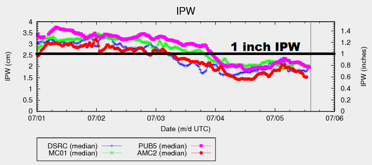
Before jumping into the subtle changes between today’s atmospheric setup and yesterday’s, let’s take a look at the IPW graph below. You will notice that the amount of moisture across the state has remained nearly steady yesterday and today, after falling steadily through the afternoon/evening on July 3rd. As for the subtle changes to the atmospheric setup, these include a weak cool front sliding across Wyoming and a weak, mid-/upper-level disturbance that will work across northern Colorado this afternoon/evening. The front will try to dip into the Northeast Plains, but will likely be washed out by ongoing shower/thunderstorm outflow.
Generally speaking, the weak disturbance and cool front will focus the bulk of shower/thunderstorm activity over the Northern Mountains, Front Range, and along the CO/WY border across the Northeast Plains. Additionally, isolated-to-scattered showers/thunderstorms will move across/develop over the Urban Corridor, Palmer Ridge, and northern portions of the Southeast Plains. Further south, dry and mostly sunny conditions will prevail as temperatures climb a few degrees above average for the date.
Over the remainder of the High Country, the higher terrain will see a couple isolated showers/weak thunderstorms today. Not much in the way of rainfall is expected as they will be fairly high-based with drier air below cloud level. Lower elevations will remain dry, minus a quick shower over downwind valleys as activity over the higher terrain moves overhead (before quickly diminishing). For more details regarding timing and rain rates, please see the zone-specific forecast discussions below.
Today’s Flood Threat Map
For more information on today’s flood threat, see the map below (hover over threat areas for more details). For Zone-Specific forecasts, jump below the map.

Zone-Specific Forecasts
Urban Corridor, Northeast Plains, Palmer Ridge, and Southeast Plains:
Isolated-to-scattered showers/thunderstorms are expected over the Urban Corridor, Palmer Ridge, and Northeast Plains. Most will be garden-variety. Over the far Northeastern Plains, a strong/severe thunderstorm or two is possible, with the main threat being strong winds/hail. For the Southeast Plains, only northern portions are expected to see any activity. For central and southern sections, skies will be mostly sunny with high temperatures climbing 3-5 degrees above average. Maximum rain rates are as follows:
Urban Corridor: 0.3-0.5 inches/hour
Palmer Ridge and Southeast Plains: 0.4-0.7 inches/hour
Northeast Plains: 0.8-1.2 inches/hour
Timing: 2 PM – 10 PM
Northern Mountains, Central Mountains, and Front Range:
Scattered showers/weak thunderstorms are expected this afternoon and evening. Most will be garden variety, resulting in mainly light rainfall and gusty winds. Storms will end from west to east this evening. Maximum rain rates will be 0.4-0.7 inches/hour.
Timing: Noon – 8 PM
Northwest Slope, San Juan Mountains, Southeast Mountains, Raton Ridge, Southwest Slope, Grand Valley, and San Luis Valley:
A couple of isolated showers/weak thunderstorms are possible over the higher terrain, with probabilities decreasing from north to south. Most locations will remain dry. Cloud coverage will be greatest over northern zones, decreasing to the south. Maximum rain rates from any storms will be less than 0.25 inches/hour.
Timing: Noon – 8 PM