Issue Date: 8/16/2016
Issue Time: 9:33 AM
NO FLOOD THREAT IS FORECAST.
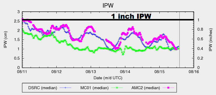
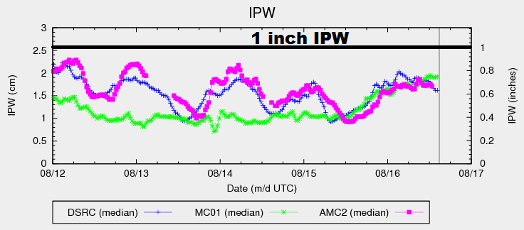
Precipitable water increased steadily throughout the afternoon/evening yesterday before leveling off overnight, as shown in the graph below. Another bump from current readings is expected today, pushing IPW values to 0.8-0.9 inches at the 3 reporting locations below (Grand Junction, Boulder, and Schriever AFB). A little better moisture will exist further east over the plains, thanks to better surface moisture values with dewpoints in the 40s/low 50s. Aloft, the important feature will be a weak mid-level disturbance that is expected to rotate across the state this afternoon and evening.
Overall, there is enough moisture for the weak mid-level disturbance to work with, kicking off isolated-to-scattered showers/storms. The best coverage will occur over the High Country and Western Slope, with more isolated coverage over the lower elevations of eastern Colorado. A closer inspection of moisture, however, reveals an inverted-V atmospheric profile, with most of the moisture existing above 2.5 km aloft. As the day wears on, some of that moisture will mix closer to the surface, helping boost rain rates a bit during the late afternoon and evening hours, but not enough to warrant any flood threat issuance. For more information on timing and rain rates, please see the zone-specific discussions below.
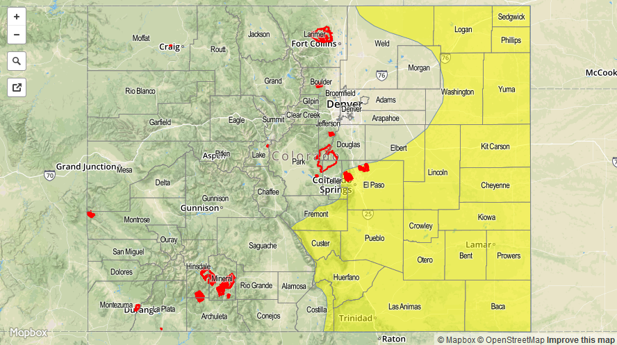
Today’s Flood Threat Map
For more information on today’s flood threat, see the map below (hover over threat areas for more details). For Zone-Specific forecasts, jump below the map.

Zone-Specific Forecasts
Urban Corridor, Northeast Plains, Palmer Ridge, Southeast Plains and Raton Ridge:
Isolated showers/thunderstorms expected to move off of the higher terrain and over the lower elevations this afternoon and evening. The main threats from storms will be gusty winds up to 30-40 mph and lightning, with light-to-moderate rainfall. A brief period of locally moderate-to-heavy rainfall cannot be ruled out, especially with interacting outflow boundaries. If heavy rain occurs, minor street/field ponding will be the main impact. Maximum rain rates are as follows:
Northeast Plains, Southeast Plains, and Palmer Ridge: 0.8-1.4 inches/hour
Urban Corridor and Raton Ridge: 0.6-1.0 inches/hour
Timing: 1 PM – Midnight
Front Range, Southeast Mountains, Northern Mountains, Northwest Slope, San Juan Mountains, Southwest Slope, San Luis Valley, Central Mountains, and Grand Valley:
Scattered showers/thunderstorms are expected today/tonight. The best coverage will occur across the higher terrain, with widely scattered showers/storms drifting over the lower elevations. Drier air in the low levels will temper rain rates today, leaving the main impacts to be gusty winds (up to 30-40 mph) and lightning. Most activity will produce light-to-moderate rainfall, but a stronger storm or two producing brief locally heavy rainfall is possible. Burn scars, especially the Hayden Pass fire burn scar, should be monitored closely as a precaution, but no flood threat is warranted. Maximum rain rates are as follows:
Southwest Slope, San Juan Mountains, Front Range, and Southeast Mountains : 0.6-0.8 inches/hour
Central Mountains, San Luis Valley, and Grand Valley: 0.5-0.8 inches/hour
Northern Mountains, Northwest Slope: 0.4-0.6 inches/hour
Timing: 11 AM – 10 PM, with a couple isolated showers continuing into the morning hours over the higher terrain of southwestern Colorado