Issue Date: 9/5/2016
Issue Time: 9:05 AM
NO FLOOD THREAT IS FORECAST.
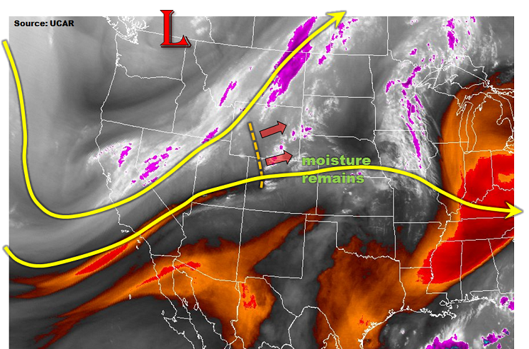
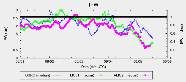
Moisture has taken a significant dip since yesterday afternoon as dry southwest flow aloft has overspread Colorado. This drier air is very apparent in the IPW chart below, showing values steeply declining for the last 12 hours or so. This drier air will result in much of the state experiencing a mostly sunny (and dry) Labor Day holiday. The exception to this rule will be across far southern and southeastern Colorado, along and east of a developing dryline. Weak support aloft will help kick off isolated thunderstorms in this area, with the main threats being strong winds and hail. Moisture values are too low to warrant any flood threat considerations.
Another threat today is the developing high fire danger across high valleys in the Northern Mountains and Front Range regions, across the Palmer Ridge, and for the lower valleys of far western Colorado. Relative humidity values will drop to near (or just below) critical values, and combined with the gusty winds, will bring the fire threat back into the discussion. A mitigating factor, so to speak, is recent days’ rainfall keeping most fuels above critically dry designation. However, locations that have not received much rain lately will have the driest fuels, and extreme caution needs to be exercised. For more information, including the exact location of Red Flag Warnings, please visit the website of your local National Weather Service office.
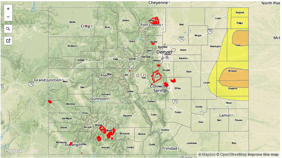
Today’s Flood Threat Map
For more information on today’s flood threat, see the map below (hover over threat areas for more details). For Zone-Specific forecasts, jump below the map.

Zone-Specific Forecasts
Northeast Plains, Urban Corridor, Palmer Ridge, Southeast Plains, and Raton Ridge:
Mostly sunny and dry for most, with high temperatures a few degrees warmer than yesterday’s high temperatures. A couple isolated thunderstorms will develop across the far Southeast Plains and Raton Ridge regions, with the main threats being strong winds, hail, and lightning. Brief periods of light-to-moderate rainfall will also attend these storms, with maximum rain rates of 0.4-0.8 inches/hour. Minor street/field ponding may occur underneath the strongest storms, but no flood threat is warranted.
Timing: 1 PM – 9 PM, with one or two storms lingering until around midnight
Front Range, Southeast Mountains, Northern Mountains, Northwest Slope, Grand Valley, Central Mountains, San Juan Mountains, Southwest Slope, and San Luis Valley:
Plenty of sunshine and dry conditions will be the main weather story today across these regions, with high temperatures similar to yesterday. High fire danger conditions exist across portions of the Front Range, Northern Mountains, Grand Valley, San Juan Mountains, and Southwest Slope regions, so please exercise caution if you plan on doing anything outdoors today. An isolated thunderstorm or two cannot be ruled out over far southern portions of the San Juan Mountains, San Luis Valley, and Southeast Mountains, as a subtle dry line lays across the region. The main threats from any storm activity will be gusty winds and lightning, with periods of light-to-moderate rainfall. Maximum rain rates will be 0.15-0.3 inches/hour.
Timing: Noon – 9 PM, with one or two isolated showers/weak thunderstorms developing overnight/early tomorrow morning