Issue Date: Saturday, September 3rd, 2016
Issue Time: 10:00AM MDT
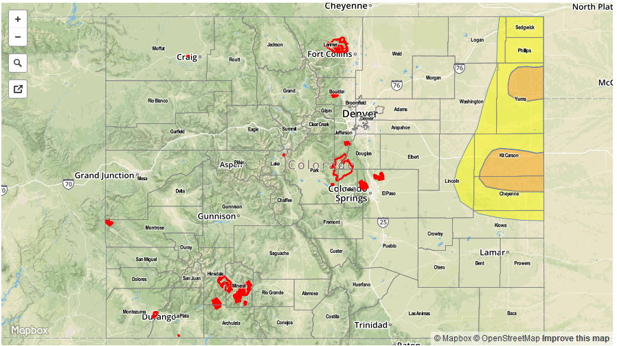
— MODERATE flood threat for parts of Northeast Plains that received heavy rainfall yesterday
— LOW flood threat for parts of the Northeast Plains
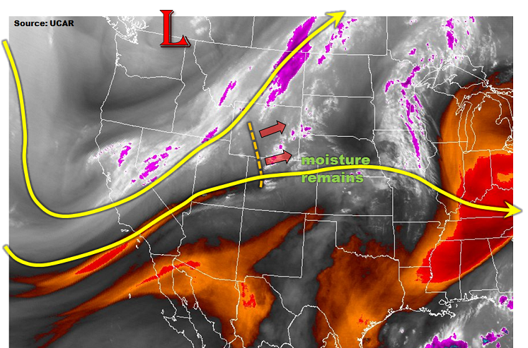
The broad, low-pressure trough will continue to support scattered shower and storm chances across Colorado, as seen in the water vapor image below. For the vast majority of areas, this will be nuisance variety rainfall because low-level moisture has dropped over the past 24-hours. The only region of concern today is once again across the eastern Plains. A disturbance located across western Colorado will rapidly move east-northeast today. As it clips the northeast corner of the state, plenty of instability from widespread sunshine will combine with southeasterly moist flow to produce thunderstorms in the area. A Low flood threat is in place for parts of the region for isolated flash flooding. However, Moderate flood threat is in place for parts of Weld County and parts of Kit Carson and Cheyenne counties due to the high antecedent rainfall and thus high runoff from any additional rain that falls. For everyone else, enjoy a generally pleasant start to the Labor Day weekend!
Today’s Flood Threat Map

Zone-Specific Forecasts:
Northeast Plains, Southeast Plains, Palmer Ridge:
Scattered thunderstorms and showers developing by 1PM. Max 1-hr rain rates up to 2.7 inches, with max 3-hr rates up to 3.7 inches. A Moderate flood threat is in place for parts of the region that saw high antecedent rainfall yesterday, with a Low threat surrounding that. Large hail, up to 1.5 inches and winds up to 70 mph will possible with the strongest cells. Storms will move quickly east/southeast, and dissipate within a few hours after sunset.
Primetime: 3PM to 10PM
San Juan Mountains, Southwest Slope, Grand Valley, Central Mountains, San Luis Valley, Northwest Slope, Northern Mountains:
Partly cloudy with scattered showers and weak thunderstorms increasing in coverage through the day. Max 1-hr rainfall up to 0.5 inches with max 24-hour totals up to 0.9 inches possible over the higher terrain of the Northern and Central Mountains. Snow level will be 12,500 feet.
Primetime: Noon to 8PM
Front Range, Urban Corridor, Southeast Mountains, Raton Ridge:
Mostly cloudy with scattered showers early transition to scattered thunderstorms by early afternoon. Max 1-hr rainfall up to 0.6 inches possible. Hail up to 0.5 inches and winds up to 50 mph are possible with the strongest storms. Flooding is not expected today.
Primetime: 1PM to 7PM